
AI Flood Detection: 7 Powerful Ways Transforming Agriculture
Meta Description:
Unlock the future of agriculture and forestry with AI flood detection, satellite imagery, and remote sensing technologies—enabling precision management, timely interventions, and sustainable productivity.
“AI flood detection systems can analyze over 10,000 satellite images daily to monitor agricultural flood risks.”
Table of Contents
- Introduction: The Significance of AI Flood Detection in Agriculture & Forestry
- The Essential Role of AI in Modern Flood Detection
- 7 Powerful AI Flood Detection Applications Transforming Agriculture & Forestry
- Comparative Table: AI-Powered Flood Detection vs. Traditional Methods
- Farmonaut: AI-Driven Satellite-Based Precision Management
- Key Challenges & Considerations in AI Flood Detection Implementation
- Future Outlook: The Evolution of AI Flood Detection in Agriculture
- Frequently Asked Questions (FAQ)
- Conclusion


Introduction: The Significance of AI Flood Detection in Agriculture & Forestry
Flooding poses a significant threat to global agriculture, farming, and forestry. With escalating impacts due to climate variability, floods increasingly endanger croplands, disrupt planting and harvesting schedules, degrade soil, and accelerate forest decline. According to recent studies, global agricultural losses due to flooding reach billions of dollars annually, weakening food security and eroding farmer livelihoods.
Traditional flood detection methods, such as manual site inspections, static sensor networks, and spotty local reports, often fall short in providing timely, accurate information for effective mitigation. Stakeholders—farmers, policy makers, and insurers—face a pressing challenge: how to leverage modern technologies to anticipate and respond to flood risks more proactively.
This is where artificial intelligence in flood detection—powered by advances in satellite imagery for agriculture, remote sensing technologies, and machine learning—steps in to revolutionize flood prediction, mitigation, and management. This transformation has become essential for building resilience and sustainability in agriculture and forestry across the globe.

The Essential Role of AI in Modern Flood Detection
AI flood detection leverages machine learning algorithms and remote sensing technologies to analyze vast datasets, enabling effective identification and monitoring of flood events with unmatched accuracy. By processing satellite imagery, sensor data (including soil and water level sensors), and historical weather records, these systems can predict flood occurrences, assess potential impact, and facilitate timely interventions.
- Data-driven systems: AI sifts through multi-source data—satellites, in-field sensors, weather stations, and historic flood maps—to build contextual, real-time insights.
- Pattern recognition: Machine learning in agriculture trains detection models to spot early flood signals from subtle changes in vegetation, soil moisture, or river levels undetectable to the human eye.
- Proactive management: AI-based early warning systems for floods enable precision resource management, insurance claims processing, and policy-making grounded in evidence.
The integration of artificial intelligence with satellite imagery for agriculture and remote sensing technologies is rapidly becoming a game-changer in precision farming solutions, forest management, and disaster resilience initiatives.
7 Powerful AI Flood Detection Applications Transforming Agriculture & Forestry
1. Early Warning Systems for Floods
Early warning systems for floods are perhaps the most critical application of AI flood detection in agriculture. These systems combine multiple advanced technologies to deliver real-time predictions and rapid alerts to farmers, upstream managers, forestry officials, and disaster response units.
- Integration of data: AI models synthesize satellite imagery, current and forecast weather data, local river and rainfall sensors, and historical flood records.
- Predictive algorithms: Using machine learning in agriculture, these systems automatically detect patterns showing imminent flooding—months, days, or hours in advance.
- Automated alerts: SMS, app notifications, and web dashboards can deliver proactive, location-specific warnings—empowering farmers to move equipment, harvest early, or shore up field protection.
- Impact: By reducing the time to detection and enabling early decisions, these systems are shown to prevent significant crop loss, resource waste, and long-term soil erosion.
Early warning systems, driven by AI flood detection, are revolutionizing resilience for communities in flood-prone agricultural areas worldwide.
2. Crop Insurance Assessment & Claims Processing
Flood damages not only undermine yields but also complicate the process of crop insurance assessment. Traditional assessment relies on in-person surveys, which are delayed, sometimes biased, and hard to scale—especially after widespread flooding.
- Satellite imagery for agriculture: High-resolution multi- and hyper-spectral images, especially Synthetic Aperture Radar (SAR), enable all-weather monitoring of crop conditions before, during, and after flood events.
- Automated AI analysis: Flood detection algorithms rapidly compare pre-flood and post-flood images, flagging inundated fields, damaged areas, and overall loss assessment per farm or region.
- Real-time reporting: AI-driven assessment feeds help insurers, governments, and large agribusinesses automatically quantify losses, process claims efficiently, and initiate disaster payments far quicker than manual surveys.
AI-powered crop damage assessment is indispensable for financial protection, timely compensation, and economic stability in farming communities, especially as climate variability increases the frequency of extreme events.
For organizations seeking advanced, automated support for crop loan and insurance programs, Farmonaut’s Satellite-Based Crop Verification Services offer scalable solutions that combine satellite, AI, and weather-based assessments to streamline insurance workflows and reduce fraud.
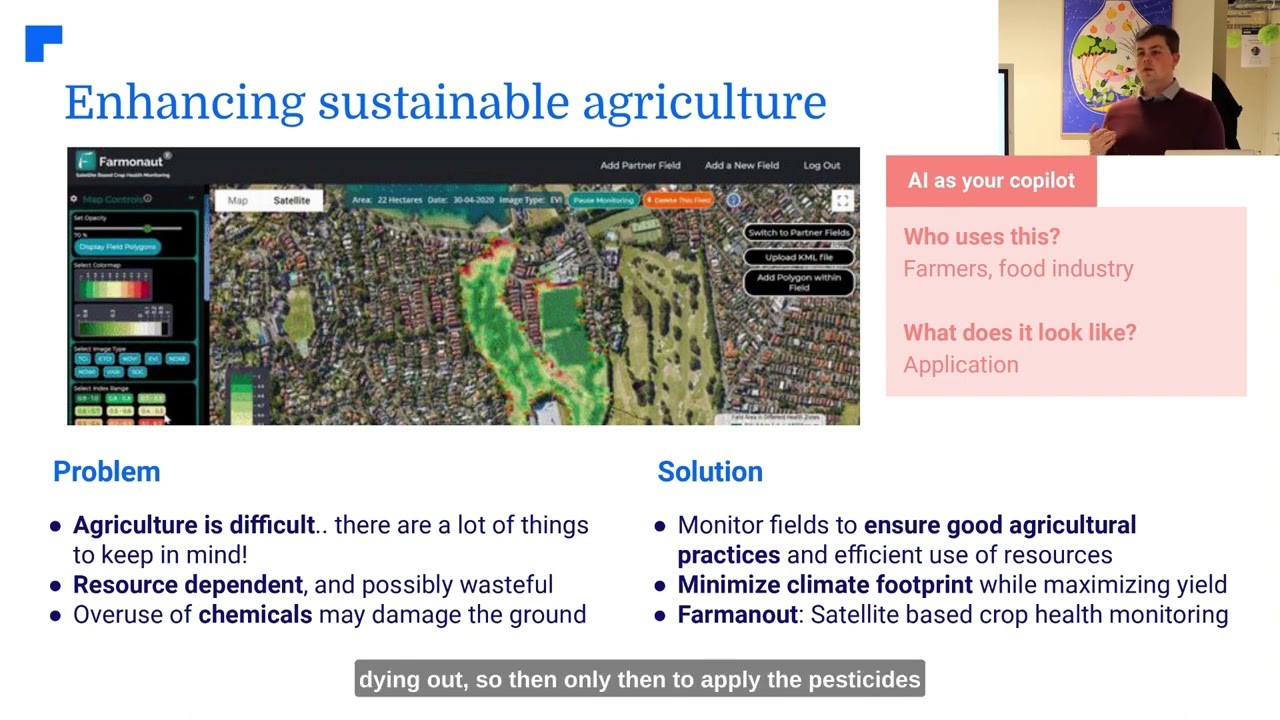
3. Precision Farming Solutions: Soil Moisture Monitoring & Flood Risk Avoidance
Precision farming solutions rely on accurate, timely data to optimize resource use—especially water—and to minimize risks from unanticipated flooding or long-term soil moisture imbalance.
- Soil moisture monitoring: AI algorithms analyze satellite and in-field sensor data to generate highly accurate, real-time soil moisture maps. By identifying wet patches, standing water, or drainage issues, these systems assist in both flood risk assessment and irrigation control.
- Resource management: Machine learning in agriculture models factor historical trends and local anomalies to recommend irrigation schedules, fertilizer application, and cultivation patterns resilient to both drought and flood.
- Inputs optimization: By dynamically adjusting water and nutrient supply to actual crop need—and reducing waste—precision farming enhances sustainability and yield reliability.
Accessible soil moisture monitoring and precision farming solutions enable farming operations to be more proactive and climate-adaptive than ever before.
To enable this, Farmonaut’s Remote Sensing Platform delivers real-time crop and soil health analytics for farmers, cooperatives, and governments looking for affordable, scalable solutions for complete farm and resource management.
4. Forest Management with AI: Deforestation Monitoring
AI-powered flood detection does not stop at croplands. In forestry, remote sensing technologies and AI algorithms collaborate to monitor changes in forest cover—often a precursor to flooding risks downstream.
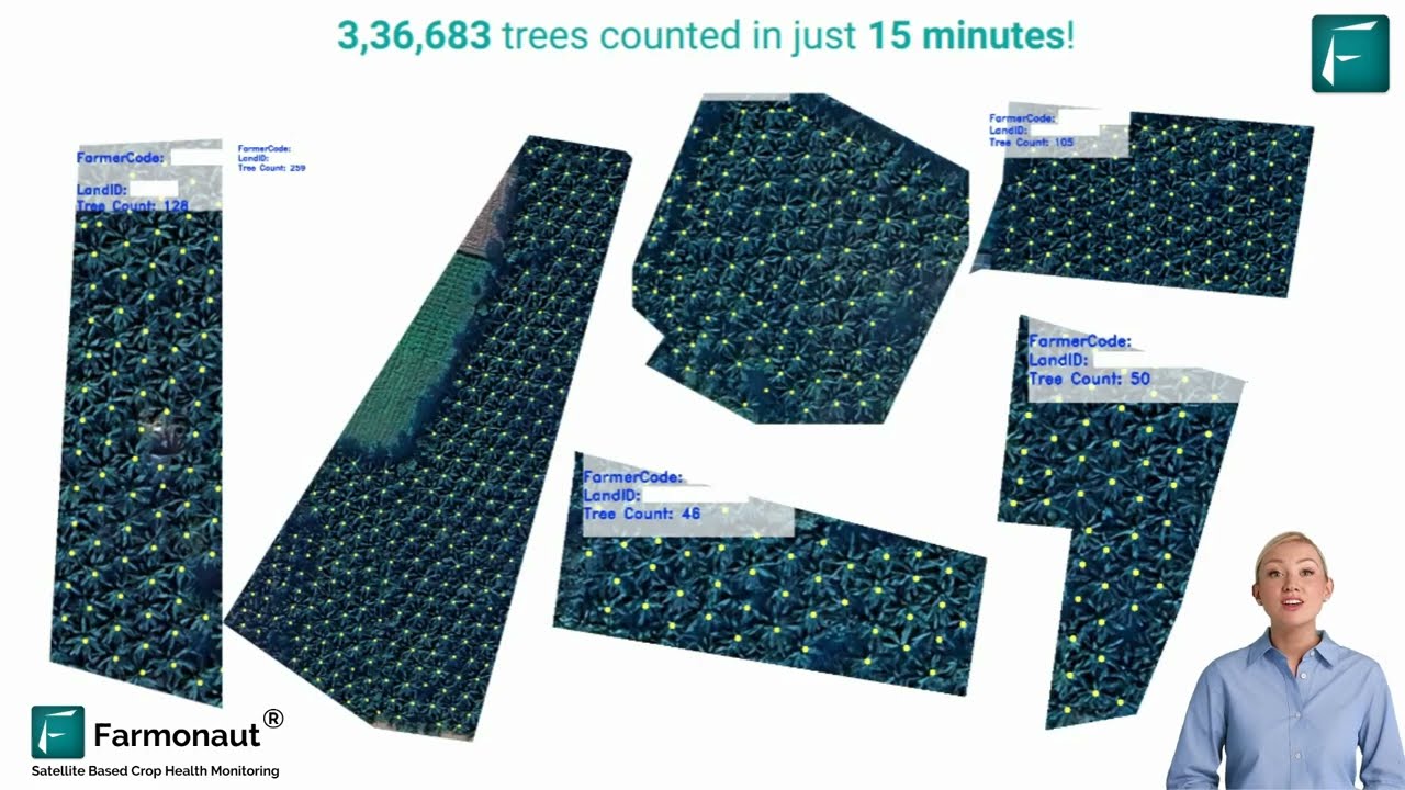
- Change detection: Advanced satellite imagery and LiDAR analysis reveal subtle shifts in forest density, tree fall, or illegal logging—detecting deforestation events before their impact is fully realized.
- Flood hazard mapping: AI overlays past flood data, hydrological patterns, and forest cover maps to identify areas newly prone to flooding after vegetation loss.
- Conservation & mitigation: By precisely identifying forest erosion or degradation hot spots, stakeholders can implement targeted reforestation and riverbank stabilization efforts.
Such forest management with AI has become vital in the face of increasing deforestation and unpredictable weather, aiming for long-term climate resilience.
For policymakers and conservationists, Farmonaut’s Forest Advisory Solutions offer advanced deforestation monitoring and reporting through AI and multi-spectral satellite analytics.
“Remote sensing technology enables 90% faster flood mapping in forests compared to traditional ground surveys.”
5. Disease and Pest Detection
Flooding, coupled with changing climate, often leads to disease outbreaks and pest infestations in croplands and forests. Remote sensing technologies and machine learning models are rapidly enhancing early detection and targeted intervention capabilities.
- Multispectral imagery analysis: AI algorithms scrutinize subtle changes in leaf reflectance, canopy patterns, or color variation from satellite imagery to spot the early onset of crop or tree disease.
- Pest monitoring: By identifying unusual plant stress or growth retardation, algorithms help detect pest outbreaks before they cause widespread flood-exacerbated yield losses.
- Actionable insights: AI-generated disease and pest maps inform rapid, localized treatment, minimizing damage and preventing secondary floods from vegetation dieback.
AI-based disease and pest detection is transforming agroforestry resilience by protecting both food security and natural ecosystems.
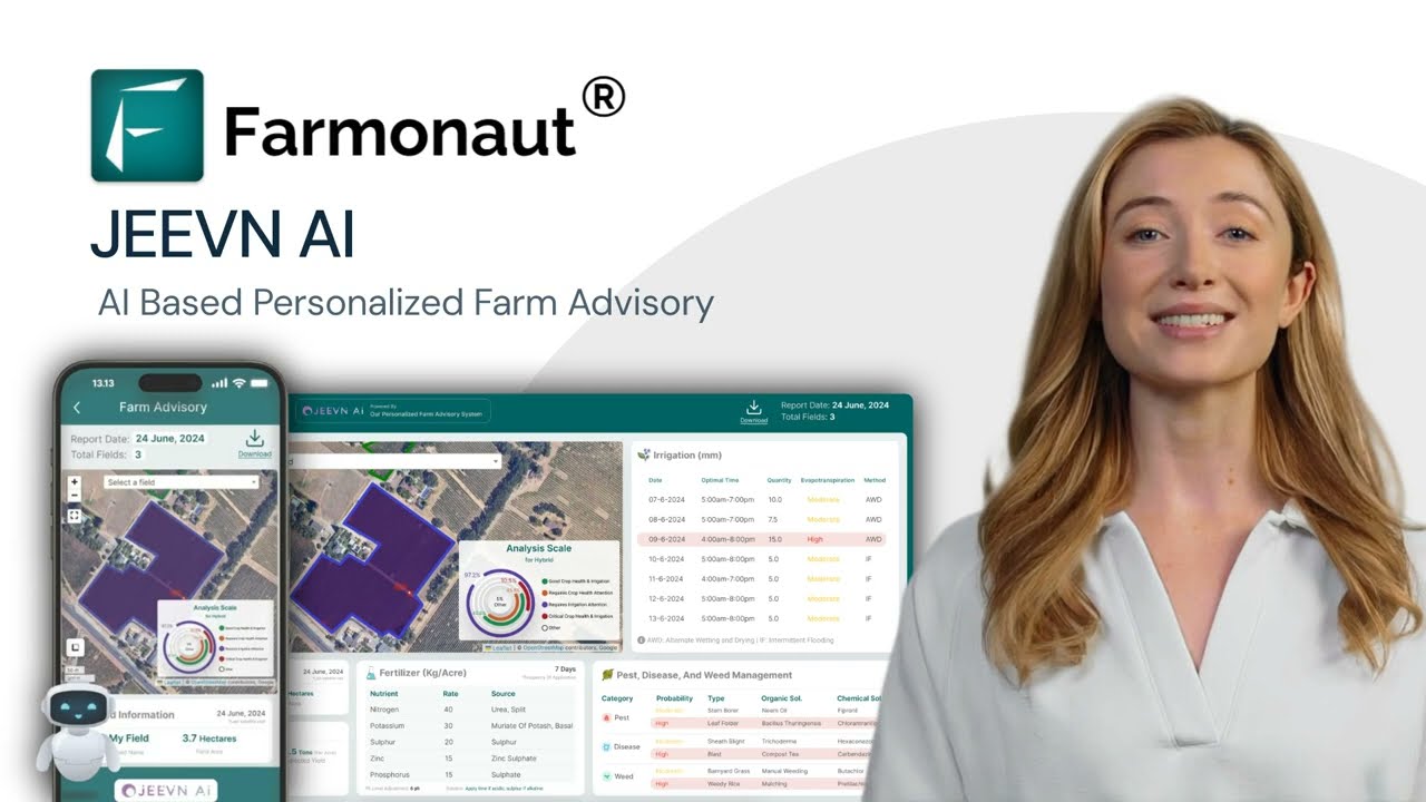
Farmers seeking automated risk alerts and actionable guidance can access tools like Farmonaut’s Jeevn AI Advisory System, which provides up-to-date, region-specific advice on disease, pest, and flood risk mitigation.
6. Flood-Driven Fire Risk Assessment
It might seem counterintuitive, but post-flood conditions can elevate fire risks in forests. Saturated landscapes dry quickly under heat, leaving behind deadwood and new undergrowth—fuel for wildfires. AI flood detection systems are now critical for fire risk assessment in both croplands and woodlands.
- Environmental monitoring: AI models integrate weather forecasts, soil moisture, vegetation indices, and wind conditions from remote sensing to continually assess fire potential.
- Dynamic risk maps: By comparing historical data with current conditions, AI systems predict which areas are transitioning from flood risk to fire risk, enabling real-time resource allocation.
- Prevention and preparedness: Early warnings allow for strategic burning, fuel load reduction, and rapid response—minimizing the risk of catastrophic wildfire events triggered by post-flood vegetation changes.
By tying together flood and fire management, AI amplifies resilience across the rural landscape.
7. Satellite & Remote Sensing Technology Integration
The true strength of contemporary AI flood detection lies in the seamless integration of satellite imagery for agriculture with in-situ sensor networks and cloud-based machine learning.
- Continuous monitoring: Satellites pass over agricultural and forestry zones multiple times a week, capturing high-resolution, multi-spectral data even during cloud cover or at night (e.g., with SAR).
- IoT sensors augmentation: Ground-based weather, water, and soil moisture sensors feed hyperlocal readings into AI systems, refining model predictions.
- Scalable, global coverage: AI platforms process data from diverse sources, offering reliable models applicable to small family farms and vast plantations alike.
- Timely, actionable information: AI-based dashboards synthesize this data into maps, trends, and forecasts usable by farmers, agribusinesses, agencies, and insurers.
For institutions and agritech developers, Farmonaut’s Satellite API delivers advanced, scalable access to remote sensing and AI-based flood risk analytics. Developers can find comprehensive documentation at Farmonaut’s Developer Docs for seamless integration.
Comparative Table: AI-Powered Flood Detection vs. Traditional Methods
The following table provides a concise, side-by-side comparison of the seven main AI-powered flood detection approaches versus traditional methods, focusing on the key technology used, estimated accuracy, response time, cost efficiency, and application area.
| Flood Detection Method | Key Technology Used | Estimated Accuracy (%) |
Response Time (Hours) | Cost Efficiency (Estimated % Savings) | Application Area |
|---|---|---|---|---|---|
| Early Warning Systems for Floods | Machine Learning, Satellite Imagery, IoT Sensors | 92-97 | 1-6 | 40-65 | Both |
| Crop Insurance Assessment | SAR Imagery, Automated AI Assessment | 89-94 | 8-24 | 50-70 | Agriculture |
| Precision Farming Solutions | Remote Sensing, Soil Moisture Analytics | 90-96 | 2-12 | 35-60 | Agriculture |
| Deforestation Monitoring | Satellite & LiDAR, Change Detection AI | 88-94 | 12-24 | 45-68 | Forestry |
| Disease & Pest Detection | Multispectral Imagery, Pattern Recognition ML | 86-92 | 3-16 | 30-55 | Both |
| Fire Risk Assessment | Environmental Sensors, Climate Data, AI Models | 85-90 | 2-10 | 40-63 | Forestry |
| Satellite & Remote Sensing Integration | Satellite Multi-sensor, IoT, ML Fusion | 91-98 | 1-4 | 60-80 | Both |
| Traditional Manual Methods (Comparison) | Field Surveys, Paper Records | 55-70 | 24-168 | 0-10 | Both |
Farmonaut: AI-Driven Satellite-Based Precision Management
At Farmonaut, we are committed to democratizing precision agriculture through affordable satellite-based farm management solutions. Our platform combines powerful AI flood detection, high-frequency satellite imagery analysis, blockchain-based traceability, and advanced weather and resource management tools into a single, user-friendly ecosystem.
- Real-time crop and soil health monitoring enables farmers to access crucial metrics like NDVI, soil moisture levels, and vegetation stress indicators, driving timely and informed decisions for resilient farming operations.
- Jeevn AI Advisory System empowers users with on-demand AI-generated guidance, including weather-driven interventions, resource optimization, and early warnings for flood/disease risks via mobile, web, or integrated APIs.
- Blockchain-powered traceability ensures transparency from farm to shelf—crucial in food safety, compliance, and global supply chain trust.
- Fleet, area, and resource management tools support agribusinesses and public agencies in coordinating large-scale logistics, plantation oversight, and infrastructure resilience.
Our solutions are available via the Farmonaut Android app  , iOS app
  , browser dashboard, and API endpoints for seamless integration into third-party systems.

For corporate clients and cooperatives, solutions like Farmonaut Traceability ensure secure, end-to-end visibility in agri supply chains, while carbon footprinting features empower climate-smart sustainability reporting.
For governments, agribusinesses, and large farm operators, our Large-Scale Farm Management suite is specifically optimized for remote, distributed plantation supervision, area estimation, and resource allocation.
Key Challenges & Considerations in AI Flood Detection Implementation
Despite its transformative benefits, wide-scale implementation of AI flood detection systems faces several obstacles:
- Data quality & availability: High-resolution, up-to-date data is crucial for accurate predictions. Remote or rural regions may lack reliable sensor or weather coverage.
- Farmer adoption: Technology is only as effective as its uptake. Education, user-friendly interfaces, and trust-building are vital to encourage broad adoption, particularly among smallholder farmers.
- Infrastructure & connectivity: Real-time AI systems require dependable digital infrastructure and internet—often a challenge in developing areas prone to flooding.
- Interpretability: Black-box AI models must be paired with explainable analytics so stakeholders understand alerts and recommended interventions.
- Privacy & security: Handling sensitive farm, insurance, and environmental data demands strong cybersecurity protocols and compliance with evolving data protection regulations.
Addressing these challenges demands a blend of technological innovation, community engagement, robust infrastructure investment, and responsive policy planning.
Frequently Asked Questions (FAQ)
-
What is AI flood detection and how does it work?
AI flood detection refers to the use of artificial intelligence—particularly machine learning algorithms and remote sensing data—to analyze large datasets and detect or predict flood events with high precision. These systems incorporate satellite imagery, sensor data, weather forecasts, and historical records to issue early warnings and assist in real-time flood monitoring, risk assessment, and disaster management.
-
How does satellite imagery for agriculture help manage floods?
Satellite imagery provides continuous, global, and all-weather surveillance of agricultural landscapes. By comparing historical and new images (including SAR and multispectral data), AI systems can detect water inundation, crop damage, and shifts in soil moisture—enabling timely interventions and accurate disaster assessment for farmers and insurers.
-
What are the benefits of machine learning in agriculture for flood mitigation?
Machine learning algorithms excel at identifying patterns and predicting future risks, even in complex, data-rich environments. In agriculture, ML-driven flood detection enables early warning systems, smart resource allocation, improved insurance workflows, and proactive farm management—all of which reduce loss and optimize productivity.
-
Which remote sensing technologies are used in flood detection for forestry?
Forestry flood risk assessment utilizes multispectral and SAR satellite imagery, LiDAR scans, ground-based IoT sensors, and AI-powered analytics to detect changes in forest cover, soil moisture, pest outbreaks, and post-flood fire risks.
-
How can farmers access precision farming solutions for flood management?
Solutions like Farmonaut’s platform deliver real-time, AI-driven advisory via web dashboards, mobile apps, and APIs. These systems offer NDVI crop health, soil moisture monitoring, weather-based interventions, and customized alerts that empower farmers to make precise, informed decisions before, during, and after flood events.
-
Are AI flood detection systems affordable for small-scale farmers?
Yes. Unlike traditional precision hardware, modern AI flood detection leverages satellite data, cloud computing, and mobile connectivity, reducing costs and democratizing access. Subscription-based and flexible plans, such as those offered by Farmonaut, ensure affordability and scalability for smallholders and commercial enterprises alike.
-
What role does blockchain-based traceability play in flood-affected agriculture?
Blockchain-powered traceability preserves transparent digital records of product journeys. In flood-impacted areas, this ensures authenticity, helps verify insurance claims, and maintains consumer trust in food safety throughout the supply chain. Explore Farmonaut’s Traceability Solutions for more details.
-
Where can I learn more or try AI-powered flood detection tools?
Visit the Farmonaut Web App or download the mobile apps on the Google Play Store and Apple App Store for access to AI-driven agricultural insights, flood monitoring, and resource management tools.
Future Outlook: The Evolution of AI Flood Detection in Agriculture
The next decade promises extraordinary progress in AI flood detection and precision agriculture:
- Richer datasets and better algorithms: Progress in machine learning, satellite sensors, and data fusion will further enhance flood prediction accuracy, resolution, and resilience—even in complex and changing climates.
- Integration with smart infrastructure: Real-time AI systems will direct flood gates, irrigation, and supply chains automatically—enabling adaptive, self-healing agriculture.
- Scalable climate adaptation: Affordable tools, like those provided by Farmonaut, will empower millions of farmers worldwide to mitigate flood risks, optimize resources, and sustain productivity in the face of uncertainty.
- Collaborative innovation: Advances will come from ongoing collaboration between technology leaders, agronomists, researchers, and farmers in building inclusive, transparent, and responsible AI that works for all stakeholders.
Ultimately, AI flood detection will form the backbone of climate-resilient, sustainable, and productive agriculture and forestry—transforming how we protect our food systems and natural resources in a rapidly changing world.
Conclusion
AI flood detection is not just an emerging trend—it’s a necessary evolution for 21st-century agriculture and forestry. By harnessing satellite imagery for agriculture, remote sensing technologies, and AI-enabled analytics, we can meaningfully anticipate, prepare for, and respond to flood risks.
For individual farmers, these innovations mean less guesswork and greater resilience. For agribusinesses and policy-makers, they deliver cost savings, transparency, and sustainability. For entire supply chains and natural ecosystems, they secure future productivity against the mounting challenges of climate change.
At Farmonaut, our mission is to make precision management and smart flood detection easily accessible for every farmer, agribusiness, and stakeholder. Equipped with advances in AI, satellite data, and actionable insights, we believe the agriculture and forestry sector can approach the future with confidence and clarity.
To experience these innovations or find solutions tailored for your needs, explore our platform today:
Start making data-driven, sustainable choices for your farm or forest—powered by the latest in AI flood detection and remote sensing.


