
Use Farmonaut to Monitor Crop Growth Stages Easily: A Complete Guide to Satellite Crop Monitoring & Real-Time Insights

“Over 5 million hectares worldwide are monitored using satellite crop growth stage analysis each year.”
Table of Contents
- Introduction
- Understanding Crop Growth Stages
- Traditional Monitoring Methods vs. Satellite-Based Monitoring
- How Farmonaut Simplifies Crop Growth Stages Monitoring
- Vegetation Indices for Agriculture Used by Farmonaut
- Gaining Real-Time Crop Health Insights
- Advantages of Satellite Crop Monitoring with Farmonaut
- Implementing Satellite Crop Monitoring and Remote Sensing in Agriculture
- Farmonaut Tools, Platforms, and Integrations
- Challenges and Considerations in Crop Monitoring
- The Future of Precision Farming Technologies
- Farmonaut Subscriptions
- Frequently Asked Questions
- Conclusion
Introduction: Revolutionizing Crop Growth Stages Monitoring
Monitoring crop growth stages is essential for modern, effective farm management. As we strive to maximize yield and quality, being able to track the developmental stages of our crops enables us to deploy timely interventions such as irrigation, fertilization, and pest management. Unfortunately, traditional methods of field inspections and manual measurements can be inefficient, time-consuming, and unable to capture full spatial variability across large areas.
This is where Farmonaut’s advanced satellite crop monitoring platform makes the difference. Leveraging remote sensing in agriculture, vegetation indices for agriculture, AI, and real-time data analysis, we now have powerful, actionable insights at our fingertips that simply weren’t possible before. These technological advancements not only improve the efficiency and accuracy of growth stage monitoring, but promote sustainable farming practices as well.
In this blog, we’ll explore how to use Farmonaut to monitor crop growth stages easily, highlight the strengths of satellite crop monitoring, compare it with traditional methods, and guide you through deploying these tools for optimized, data-driven field management.


Understanding Crop Growth Stages: The Foundation of Effective Crop Monitoring
Before we implement any monitoring system, it’s crucial to understand the distinct growth stages crops undergo. Each stage demands specific management, making timely detection and intervention key for maximizing yield and quality.
- Germination and Emergence: The initial phase, where seeds sprout and establish roots. Early monitoring can help detect water issues or nutrient deficiencies before they impact full field health.
- Vegetative Growth: Characterized by leaf and stem development, leading to canopy formation. Monitoring this stage is vital for detecting pest infestations or resource deficiencies impacting biomass accumulation.
- Reproductive Stage: Includes flowering, pollination, and fruit/seed development. At this point, close attention to crop health ensures quality yield formation.
- Maturity and Ripening: The final stage where crops reach full size and nutritional content. Accurate monitoring allows for optimal harvest timing, preserving quality and minimizing losses.
Monitoring crop growth stages at each step is crucial for:
- Implementing timely irrigation management
- Adjusting fertilization as needed
- Detecting crop stress early due to pests, diseases, or resource imbalances
- Optimizing harvest timing for peak yield
With proper crop growth stages monitoring, we can directly address the challenges of modern agriculture: maximizing productivity while ensuring sustainable farming practices.
Traditional Monitoring Methods vs. Satellite Crop Monitoring
Historically, farmers and agronomists have relied on manual inspections to monitor crop growth. While these methods can provide valuable on-the-ground context, they are often:
- Labor-intensive and time-consuming, particularly as field size grows
- Prone to subjective interpretation and human error
- Unable to capture spatial variability in crop fields with high resolution
- At risk of missing early signs of disease, pest outbreaks, or nutrient deficiencies
In contrast, satellite crop monitoring driven by remote sensing in agriculture offers unparalleled coverage and insight. By capturing data across entire fields simultaneously and regularly, we gain:
- Objective, repeatable, and comprehensive crop monitoring results
- Near real-time detection of issues using vegetation indices for agriculture
- Actionable spatial mapping to target interventions precisely and efficiently
Comparison Table of Traditional vs. Satellite-Based Crop Monitoring Across Growth Stages
| Crop Growth Stage | Traditional Monitoring Method (Time/Resources) |
Satellite-Based Monitoring via Farmonaut (Time/Resources) |
Benefits/Insights Provided |
|---|---|---|---|
| Germination & Emergence | Visual checks 1-2 times/week; laborers walk fields; vulnerable to missed spots | Satellite imagery 2–3 times/week; automated analysis; no field visit needed | Early detection of germination gaps, water stress; high accuracy; immediate alerts |
| Vegetative Growth | Weekly inspections for pest/nutrient issues; manual sample collection | NDVI/EVI mapping; daily to weekly updates; spatially detailed | Spot nutrient deficiencies, pest outbreaks early; optimize field inputs |
| Reproductive/Flowering | Pre-harvest walks; subjective yield estimation; physical sampling | Continuous remote monitoring; AI-driven yield prediction and growth mapping | Quantitative, objective tracking of reproductive progress; real-time alerts |
| Maturity & Ripening | Frequent visits near harvest; potential for missed late-stage issues | Automated maturity indexing; pre-harvest quality assessments | Accurate harvest timing; reduced crop loss; quality assurance |
How Farmonaut Simplifies Crop Growth Stages Monitoring
Farmonaut’s platform brings a revolutionized process to monitor crop growth stages easily with minimal manual input. Let’s break down how farmers, agronomists, and agricultural administrators can leverage this system:
1. Field Mapping and Initialization
-
By simply drawing or uploading field boundaries within the Farmonaut app, web dashboard, or API (see API details | developer docs), we can digitize our
fields and prepare for ongoing monitoring.
2. Automated Satellite Data Analysis
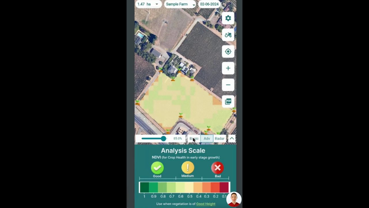
- Farmonaut leverages multispectral satellite Imagery, analyzing incoming data with cutting-edge AI, remote sensing, and ML algorithms. These provide regular updates on key vegetation indices, such as NDVI, EVI, NDRE, NDMI, and VARI.
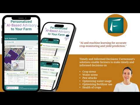
3. Real-Time Crop Health Insights and Actionable Alerts
- We receive easy-to-interpret color-coded maps and dashboards highlighting spatial variability and potential issues. Actionable advisory messages keep us informed of emerging problems like water stress, disease, or delayed development.
4. AI-Powered Farm Advisory: Jeevn AI
- With Farmonaut’s Jeevn AI advisory system, we get personalized recommendations, blending remote sensing in agriculture with hyper-local weather forecasts and agronomic best practices for even more effective management across all growth stages.
Vegetation Indices for Agriculture Used by Farmonaut
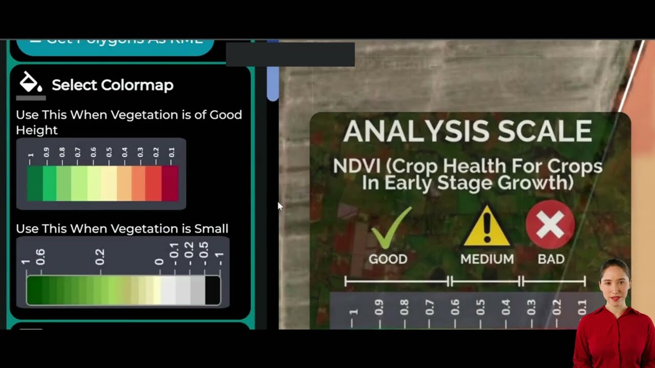
The true power of satellite crop monitoring relies on interpreting vegetation indices for agriculture. These are mathematical transformations of reflectance data in specific spectral bands, enabling us to remotely assess crop vitality, stress, and progress at each stage. Here’s how the main indices work:
- Normalized Difference Vegetation Index (NDVI):
Perhaps the most widely used vegetation index, NDVI measures the difference between near-infrared (which vegetation strongly reflects) and red light (which vegetation absorbs). It efficiently quantifies overall crop health and density.
Read more about Farmonaut’s NDVI Monitoring - Enhanced Vegetation Index (EVI):
EVI improves upon NDVI in areas with high biomass and dense canopies, increasing sensitivity to subtle stress factors including early-stage nutrient deficiencies. EVI also counters atmospheric variability for more accurate analysis.
Learn about EVI in Farmonaut - Normalized Difference Red Edge Index (NDRE):
NDRE uses the red edge spectral band, especially for detecting chlorophyll content and nitrogen status in later growth stages. It’s particularly valuable just before reproduction and during maturity.
See how Farmonaut applies NDRE - Normalized Difference Moisture Index (NDMI):
NDMI is crucial for timely irrigation management by estimating water stress and moisture content in crops, supporting effective drought management.
Explore NDMI for moisture insights - Visible Atmospherically Resistant Index (VARI):
VARI is less affected by atmospheric conditions and excels in areas of sparse vegetation. It enables monitoring where other indices might fail due to dust or cloud interference.
Details on Farmonaut’s use of VARI
Interpreting these indices accurately gives us a reliable perspective on every key crop growth stage, from germination to maturity.
“Satellite remote sensing can detect crop growth changes as small as 10 meters on the ground.”

Gaining Real-Time Crop Health Insights: Powerful Solutions at Your Fingertips
One of the primary benefits of using Farmonaut is our ability to obtain real-time crop health insights—something that’s simply not possible with traditional methods or periodic field visits. With Farmonaut’s satellite monitoring, we can:
- Monitor spatial variability in crop fields to identify zones needing intervention
- Detect crop stress early before visible symptoms appear
- Pinpoint nutrient deficiencies, water stress, or early-stage pest attacks
- Set up timely irrigation management strategies based on NDMI trends
- Forecast harvest readiness & orchard maturity for uninterrupted logistics
The immediacy and precision with which we can address these growth stage insights leads to direct improvements in farm yields, quality, and sustainability.

Advantages of Satellite Crop Monitoring with Farmonaut
So, what makes Farmonaut—powered by satellite-based remote sensing in agriculture—the best choice for crop monitoring across growth stages?
- Comprehensive Field Coverage: Monitor entire fields or even multiple farms regardless of geography. Satellite imagery detects spatial variability, capturing data unavailable to the naked eye and making large-scale field management scalable and efficient.
- Timely Detection & Action: Receive automated, actionable alerts for pest outbreaks, disease symptoms, water management issues, or resource imbalances as soon as they develop—long before they spread.
- Resource Optimization: Insights into the precise location and type of field stress mean we can localize interventions. This reduces fertilizer, pesticide, and water waste, lowering input costs and improving environmental sustainability.
- Increased Productivity: Optimized interventions at the right growth stage—predicted with higher accuracy—help us maintain crop vigor and maximize yields and quality.
- Supports Sustainable Farming Practices: Less chemical runoff, fewer emissions, and targeted field management mean our carbon footprint is reduced—tracking this is easy within Farmonaut’s carbon footprinting tool.
Implementing Satellite Crop Monitoring and Remote Sensing in Agriculture
Farmonaut’s platform can be accessed using our Android, iOS, and web apps or through our API interface for advanced programmatic integration. By choosing the platform best suited to our needs, we can:
- Remotely monitor smallholdings or vast agricultural operations (see our large scale farm management solutions here)
- Automate the generation of traceability records for supply chain transparency (explore product traceability for food and textile industries)
- Gain blockchain-backed traceability for premium, export-oriented, or organic crop certification
- Support satellite-based crop loan and insurance verification (details here)
- Maintain detailed reports for fleet management of large equipment and labor (see how we reduce logistics costs)
For crop plantation, forest advisory, and ongoing automation, see our full solutions: Get started here.
Farmonaut Tools, Platforms, and Integration Options
With the development of precision farming technologies, it’s never been easier to integrate real-time crop health insights into everyday management. Here’s what Farmonaut offers:
- Mobile Responsiveness: Access data anywhere, whether you’re on-site examining crops or in the office planning logistics.
- API Integration: Seamlessly connect our satellite-based crop health monitoring with external farm management, research, or supply chain tools using our documented APIs.
- Web and Desktop Dashboard: Visualize historic and ongoing field conditions, download PDF/CSV reports, and overlay yield/quality data for trend analysis.
- Blockchain Backed Traceability: Use our resources for transparent supply chains and food safety assurance.
Challenges and Considerations in Modern Crop Monitoring
While satellite monitoring unlocks many advantages, there are practical considerations to keep in mind:
- Cloud Cover: Persistent cloud cover can temporarily impact satellite imagery. (Farmonaut’s platform regularly updates as soon as clear images are available, ensuring the most up-to-date data possible.)
- Interpretation of Data: Correctly interpreting spatial, spectral, and temporal data requires agronomic knowledge—which Farmonaut’s automated advisory systems significantly simplify.
- Cost: While far more accessible and cost-effective than many alternative technologies, even innovative solutions carry an initial subscription fee. Farmonaut’s tiered pricing ensures an option for every scale of operation.
For many, the benefits in reduced waste, increased yields, and efficient interventions far outweigh these short-term hurdles.
The Future of Precision Farming Technologies
Satellite crop monitoring, remote sensing, and AI-powered advisory platforms like Farmonaut are reshaping the face of agriculture in India and globally. Ongoing developments are:
- Improving spatial and spectral resolution, allowing us to detect crop growth changes as small as 10 meters on the ground (and soon, even finer)
- Enhancing algorithm accuracy to offer predictive, prescriptive insights tailored to each field’s conditions
- Expanding blockchain-based traceability and carbon footprinting features for better transparency and sustainability
- Supporting truly sustainable farming practices to ensure food security and environmental stewardship in the decades ahead
By adopting these technologies, we empower every farmer—from smallholders in India to large agribusinesses worldwide—to thrive in a competitive, data-driven world.
Farmonaut Subscriptions: Flexible Precision Farming for Every Field
Our subscription model is built to ensure all farmers and agribusinesses—no matter the size—can access world-leading precision farming technologies, satellite crop monitoring, and sustainable management features.
Frequently Asked Questions (FAQ) on Crop Growth Stages Monitoring with Farmonaut
What is the main advantage of satellite crop monitoring vs. traditional manual inspections?
Satellite crop monitoring provides holistic, real-time insights into crop growth stages for entire fields, overcoming the limitations of subjective and time-consuming manual inspections. We can identify spatial variability, access actionable alerts, and intervene before issues escalate—all without walking the fields.
How often is satellite imagery updated on the Farmonaut platform?
Depending on your location and plan, Farmonaut receives updates every few days, ensuring near real-time monitoring so that any crop issue can be detected early, enabling timely interventions and maximizing yields.
Can Farmonaut help with irrigation and drought stress management?
Absolutely! By using indices like NDMI, Farmonaut detects even subtle variations in canopy moisture. This helps us make timely, targeted irrigation decisions—saving water, reducing costs, and minimizing stress on our crops for sustainable farming practices.
Is Farmonaut’s platform suitable for small farms in India and large commercial operations?
Yes. Farmonaut is designed for flexibility and scalability. Our solutions are equally effective for individual farmers, cooperatives, and large agribusinesses, providing crop growth stages monitoring that fits every operational requirement and budget.
Can I integrate Farmonaut with existing AgriTech or research software?
Yes—the Farmonaut API is available for seamless integration with existing tools, research platforms, or custom dashboards. View more details in our developer documentation.
How does Farmonaut contribute to supply chain transparency?
Our blockchain-based traceability module ensures that every stage of the product journey is securely recorded and verifiable, safeguarding supply chains against fraud and elevating brand trust.
How does Farmonaut enhance sustainable farming?
By enabling targeted resource application (water, fertilizer, pesticides) and precision crop monitoring at scale, Farmonaut helps reduce inputs, waste, and emissions, supporting measurable sustainability goals.
Conclusion: Embrace the Future of Crop Growth Stage Monitoring
Modern agriculture is at a turning point, and monitoring crop growth stages using satellite-based solutions like Farmonaut will define the future of effective, sustainable, and profitable farm management.
- We can now monitor fields comprehensively, detect issues with unmatched speed and precision, and enact targeted interventions to improve yields and quality.
- Farmonaut’s blend of satellite crop monitoring, AI-driven advisory, and blockchain traceability offers a unified platform for growth stage monitoring, resource optimization, and supply chain transparency.
- Through season-long, proactive management, we transform farming from reactive problem-solving to predictive, sustainable innovation.
Ready to unlock the potential of your farm?
Let’s make every stage of crop growth count—join the global movement towards precision farming, real-time actions, and agricultural sustainability with Farmonaut.


