

Reviewed August 2026 against USDA NASS and USDA ERS survey data.
Try it: Run your own numbers →
Technology adoption on US farms is no longer a niche story: USDA’s National Agricultural Statistics Service (NASS) found 27% of US farms used at least one precision agriculture practice between June 2022 and June 2023, and for the largest row-crop operations, autosteering guidance systems are now standard equipment. This article gives you the actual USDA figures behind that shift — by technology, by farm size, and by crop — plus where to find the next release when these numbers update.
Table of Contents
- How Much of US Agriculture Actually Uses This Technology
- USDA Adoption Data: Farm Size, Crop, and Practice
- The Technologies Behind the Numbers
- Calculator: Estimate Your Variable-Rate Savings
- Comparative Table: Adoption vs. Impact by Technology
- Advanced Agricultural Technology Beyond the US
- Where Satellite Platforms Like Farmonaut Fit In
- Barriers to Adoption
- Frequently Asked Questions
- Conclusion
- Try it: Run your own numbers
How Much of US Agriculture Actually Uses This Technology
“Advanced technology for agriculture” covers a specific, measurable set of practices: GPS-guided machinery, variable rate input application, yield monitoring, soil and moisture sensors, and increasingly, drones and satellite-based crop monitoring. USDA NASS’s charts-of-note series puts a number on national uptake: 27% of US farms reported using precision agriculture practices in the June 2022–June 2023 survey window (USDA ERS, charts-of-note 110550). That aggregate hides enormous variation by farm size and by practice, which is where the real story is.
The clearest signal is autosteering. On large-scale crop farms — USDA’s term for the biggest row-crop operations by acreage — 70% used guidance autosteering systems in the 2023 survey, and 68% used yield monitors, yield maps, or soil maps to guide decisions (USDA NASS, Guide to NASS Surveys). Midsize crop farms trail but are catching up fast: 52% used autosteering in the same survey year. That gap — 70% at the top end versus 52% at midsize — is the adoption curve for precision agriculture in one comparison.
- ✔ Optimize input use — cut fertilizer, water, and pesticide waste per acre
- 📊 Boost yields — detect crop stress and nutrient deficiency before visible symptoms
- 💵 Lower per-acre cost — USDA studies show a measurable savings on variable rate corn acres
- 🌱 Extend the growing window — irrigation scheduling backed by sensor data, not guesswork
- 🔗 Strengthen traceability — digital records for buyers, lenders, and insurers

USDA Adoption Data: Farm Size, Crop, and Practice
Variable rate technology (VRT) — machinery that automatically adjusts seed, fertilizer, or chemical application rates as it moves across a field, based on GPS position and a pre-loaded prescription map — has been tracked by USDA ERS long enough to show a real crop-by-crop split. Corn leads at 37.4% of acreage using VRT (2016 data), cotton follows at 22.7% (2019 data), and winter wheat trails at 18.8% (2017 data) — all figures from USDA ERS’s charts-of-note series (USDA ERS, charts-of-note). Note these are different survey years for different crops — USDA doesn’t re-survey every crop simultaneously, so don’t compare them as if measured on the same calendar.
What does VRT actually save? USDA ERS’s economic research on variable rate application found a 3.7–3.9% reduction in per-acre production costs on corn farms using the technology, drawn from recent USDA studies published through the Economic Research Service (USDA ERS, publication 105893). On a corn operation running, say, $700–$800 in per-acre input costs, that translates to roughly $26–$31 saved per acre — the calculator further down this page lets you run that math against your own acreage and cost basis rather than trusting a single national average.
Irrigation technology shows the sharpest recent movement of any category USDA tracks. In the southwestern United States, drip irrigation adoption rose 71% between 2007 and 2017, and 55% of irrigated operations in that region now use soil moisture sensors to schedule watering, per USDA NASS’s Farm and Ranch Irrigation Survey (USDA NASS, Farm and Ranch Irrigation Survey). That survey runs on a five-year cycle tied to the Census of Agriculture, with the next full release scheduled for 2027 — if you’re reading this after that date, check the link above for the updated figures before citing the 2017 numbers as current.
Drones are the newest category and the least standardized in public data. USDA does not yet run a comparable national drone-adoption survey, but industry tracking put agricultural drone adoption among Iowa farmers at 22% in 2024. That figure comes from agricultural industry sources rather than a government survey, so treat it as directional for one state rather than a national baseline — there is no USDA-equivalent drone census to cross-check it against yet.
The Technologies Behind the Numbers
Each USDA statistic above maps to a specific technology category. Here’s what each one is and how it’s deployed on US farms.

1. Precision Agriculture and GPS Guidance
Precision agriculture combines GPS/GNSS positioning, remote sensing (satellite, drone, and multispectral imagery), and field-level data to tailor inputs — seed, water, fertilizer, pesticide — to actual conditions in each part of a field rather than treating the whole field uniformly. Autosteering, the most widely adopted piece of this stack, guides tractors and combines along GPS-plotted paths to eliminate overlap and skips. That’s the practice behind USDA’s 70% large-farm / 52% midsize-farm split cited above.
- ✔ Monitor soil health and moisture precisely, optimizing irrigation timing
- 📊 Analyze crop vigor via satellite or drone imagery for early intervention
- ⚡ Reduce input waste by applying fertilizer or pesticide only where field data shows it’s needed
- ♻ Adjust planting schedules using weather forecasting and soil data together
- 🔍 Catch pest or disease pressure early with remote sensors and image analysis

Precision Tech: How It Works
- 🌍 Remote sensing: satellite or drone imagery for field-level mapping
- 💧 Soil sensors: monitor moisture, salinity, organic matter, and nutrient levels
- 🎯 Variable rate technology: apply water, fertilizer, or pesticide by zone, not by field average
- 📅 Cloud data and forecasting: plan planting and harvest windows against weather and soil data

Learn more: Explore Farmonaut’s Large-Scale Farm Management Platform for satellite-based field monitoring at operation scale.
2. Smart Sensors and IoT Devices
Soil moisture sensors, weather stations, and connected irrigation controllers are the hardware layer behind USDA’s 55% southwestern-adoption figure for irrigation scheduling. These devices report field conditions continuously rather than requiring a manual check, and many now connect directly to pump controllers for automated response.
- ✔ Real-time monitoring — know irrigation needs without a field visit
- 📊 Automation — connect to pumps and valves for scheduled or triggered watering
- 🛰 Satellite integration — combine ground sensor readings with remote imagery
- 🔄 Alerts — flag anomalies in soil moisture or crop condition before they become losses
- 🏞 Lower labor burden — fewer manual checks needed per irrigation cycle
Explore: Farmonaut’s Carbon Footprinting & Environmental Impact Platform for tracking resource use and emissions across an operation.
3. Satellite and Drone Imagery for Crop Monitoring
Multispectral satellite and drone imagery generate the yield maps and soil maps that 68% of large-scale US crop farms reported using in the 2023 NASS survey. These data layers flag crop stress, nutrient deficiency, and yield variability at a resolution no manual field walk can match across thousands of acres.
- ✔ Early warning — spot stress, pest pressure, or nutrient deficiency before visible symptoms
- 📊 Yield estimation — forecast harvest volume and plan logistics ahead of time
- 🛰 Scalable monitoring — view thousands of acres from a single dashboard
- 🔔 Alerts — get notified of anomalies without manual review of every field
- 🌾 AI-assisted interpretation — automate image analysis for faster response

Curious about API access for integrating satellite crop monitoring into your own systems?
Check out: Farmonaut API Platform | API Developer Docs

4. Traceability and Supply Chain Technology
Downstream of the field, blockchain-based traceability and modern processing technology let growers document input use, harvest timing, and handling for buyers, lenders, and certification programs. This matters directly for the USDA figures above: a farm that can document its variable rate application records or irrigation scheduling data has a stronger case with crop insurers and lenders than one relying on undocumented practice.
- ✔ Reduce post-harvest losses — shorter, better-documented supply chains
- 📦 Add value — support premium and specialty-crop market access
- 🛡 Traceable records — verifiable origin and handling data
- 🔗 Blockchain integration — tamper-proof records from harvest through distribution
Dive deeper: Farmonaut’s Blockchain-Based Product Traceability Platform documents origin, handling, and sustainability data for the full supply chain.
5. Drones and Autonomous Equipment
Agricultural drones for scouting and spraying, along with autonomous or semi-autonomous ground equipment, are the fastest-moving category and the hardest to measure nationally. The 22% Iowa adoption figure for 2024 gives one data point for one state; it is not a USDA statistic and there is currently no equivalent national drone-adoption survey to compare it against. If you need a defensible national figure, USDA’s autosteering and yield-monitor statistics (70%/68% on large farms) are the closest verified proxy for automation adoption until a dedicated drone census exists.
- ✔ Faster scouting — cover large acreage without a ground pass
- 📊 Targeted spraying — apply chemical only where imagery shows a need
- 🛠 Reduced soil compaction — lighter equipment footprint than some ground rigs
- 💡 Data collection — feed imagery directly into the same yield-mapping systems USDA tracks
Resource: Farmonaut Fleet Management Platform helps operations optimize equipment usage and logistics costs across a fleet.
Calculator: Estimate Your Variable-Rate Savings
USDA ERS found a 3.7–3.9% per-acre cost reduction on corn farms using variable rate technology. Enter your own acreage and per-acre input cost below to see what that range means in dollars for your operation — not a national average, your actual numbers.
Run your own numbers
Assumptions: based on USDA ERS’s documented 3.7–3.9% per-acre production cost reduction for corn farms using variable rate technology (publication 105893). This estimate excludes equipment purchase or lease cost, data-service subscription fees, and agronomist or operator training time — all of which affect your break-even timeline and are not part of the cited percentage.
Comparative Table: Adoption vs. Impact by Technology
| Technology | Verified US Adoption Figure | Survey / Source | Period | Documented Impact |
|---|---|---|---|---|
| Precision agriculture (any practice) | 27% of US farms | USDA ERS charts-of-note 110550 | June 2022–June 2023 | Aggregate figure across all precision practices |
| Autosteering guidance — large farms | 70% | USDA NASS | 2023 | Eliminates pass overlap/skips on GPS-guided routes |
| Autosteering guidance — midsize farms | 52% | USDA NASS | 2023 | 18-point gap vs. large farms shows adoption curve |
| Yield monitors / yield maps / soil maps | 68% (large farms) | USDA NASS | 2023 | Feeds variable rate prescriptions for following season |
| Variable rate tech — corn acreage | 37.4% | USDA ERS charts-of-note | 2016 | 3.7–3.9% per-acre cost reduction (ERS pub. 105893) |
| Variable rate tech — cotton acreage | 22.7% | USDA ERS charts-of-note | 2019 | Reduces overlap in chemical/fertilizer pass |
| Variable rate tech — winter wheat acreage | 18.8% | USDA ERS charts-of-note | 2017 | Lowest of the three tracked crops |
| Drip irrigation, SW United States | +71% adoption growth | USDA NASS Farm and Ranch Irrigation Survey | 2007–2017 | Reduces water use vs. flood/furrow methods |
| Soil moisture sensors, SW United States | 55% of irrigated operations | USDA NASS Farm and Ranch Irrigation Survey | Recent survey cycle | Drives data-based, not calendar-based, irrigation timing |
| Agricultural drones, Iowa | 22% of farmers | Agricultural industry sources | 2024 | State-level figure; no national USDA drone census yet |
This table is the full set of USDA-verified adoption figures gathered for this article — every row cites the specific survey and year it came from rather than a single blended “adoption rate,” because as the table shows, the real number depends entirely on which practice and which farm size you’re asking about.
Advanced Agricultural Technology Beyond the US
Precision agriculture adoption is not a US-only trend, and the underlying technology — GPS guidance, remote sensing, variable rate application, sensor-driven irrigation — is the same set of tools regardless of geography. Adoption pace, subsidy structures, and average farm size vary widely by country, which is why a US grower’s cost-benefit case looks different from a grower’s in the EU or in South and Southeast Asia. For a country-specific look at how these same technology categories are being adopted and supported, see our companion coverage of current technology in Indian agriculture and modern farming methods in India, which track adoption trends, government schemes, and farm-scale economics specific to that market rather than the US figures cited throughout this piece.
Where Satellite Platforms Like Farmonaut Fit In
The USDA figures above measure adoption of hardware and practices — autosteering kits, VRT-capable equipment, soil sensors. Satellite crop monitoring platforms sit alongside that hardware layer, supplying the imagery and analytics that feed yield maps and variable rate prescriptions without requiring a farm to own its own drone fleet or GIS staff. Farmonaut’s satellite-driven tools are built to make that layer accessible at any operation size.
Farmonaut’s Core Offerings in Agriculture:
- 🌏 Satellite-based monitoring: multispectral maps for crop vigor, soil health, and irrigation need
- 🤖 Jeevn AI advisory system: context-aware recommendations to support yield and reduce input loss
- 🔗 Blockchain traceability: transparent supply chain records from field to buyer
- 🧩 Fleet and resource management: optimizes equipment use and logistics costs
- 🌱 Environmental impact monitoring: tracks water and resource use for sustainability reporting
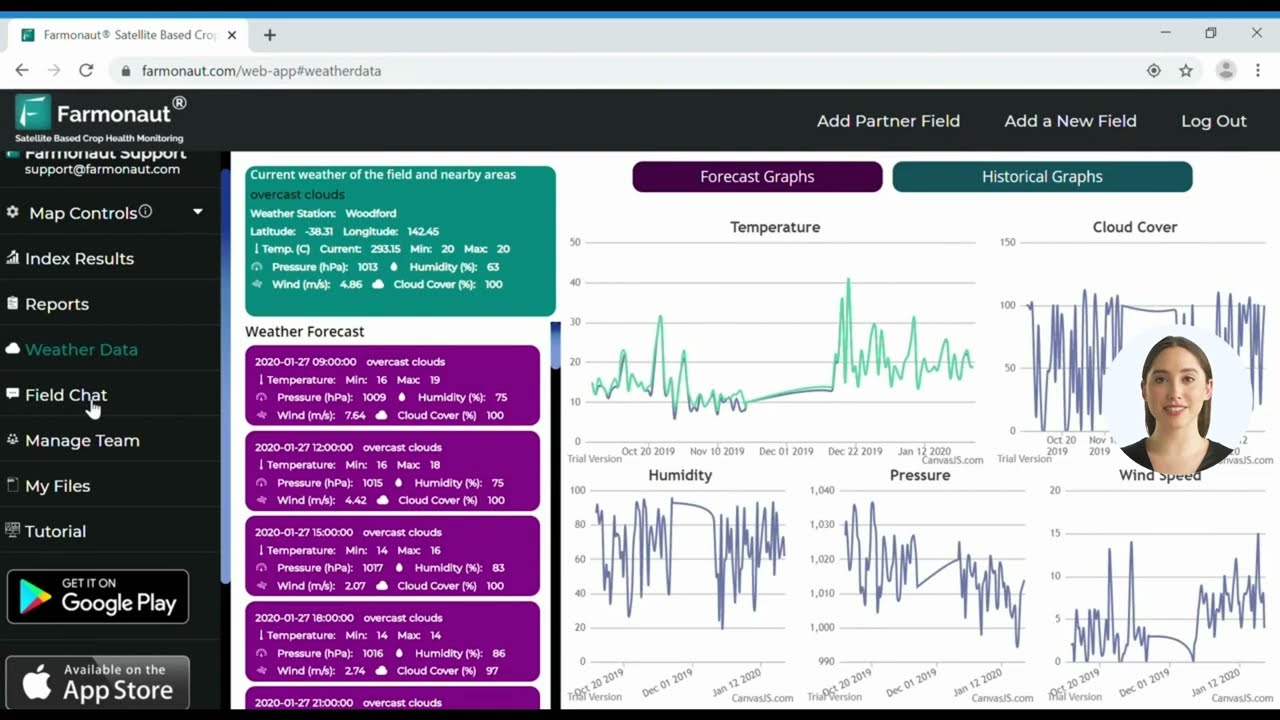
Farmonaut’s advantage: Our satellite- and AI-driven app and large-scale management tools deliver field-level advisories that mirror the same data categories USDA tracks — yield mapping, soil condition, and variable input timing — without requiring a farm to build that infrastructure in-house.



Ready to see satellite-based verification for financing?
Farmonaut’s Satellite-Based Verification supports loan and insurance eligibility documentation, backed by the same field-level data used for precision agriculture decisions.
Barriers to Adoption
The gap between large-farm adoption (70% autosteering) and midsize-farm adoption (52% autosteering) that USDA NASS documented is not accidental — it traces to specific, well-known barriers:
- 🚧 Upfront cost: GPS-guided equipment, VRT-capable applicators, and sensor networks require capital that scales more easily on larger operations.
- ⏳ Training gap: effective use of yield maps and prescription files requires operator training beyond running the equipment itself.
- 🔌 Connectivity: rural broadband gaps affect real-time data transfer for cloud-based platforms in some regions.
- 🔒 Data ownership and privacy: who owns yield and soil data collected by third-party platforms remains a live concern for many growers.
- 🛠 Interoperability: integrating new sensor and software systems with existing equipment fleets adds complexity, especially on operations running mixed-brand machinery.
Frequently Asked Questions (FAQ)
What percentage of US farms use precision agriculture technology?
USDA NASS found 27% of US farms used at least one precision agriculture practice in the June 2022–June 2023 survey window. Adoption is far higher for specific practices on specific farm sizes — 70% of large-scale crop farms used autosteering guidance in 2023, per USDA ERS charts-of-note 110550 and USDA’s Guide to NASS Surveys.
What is the most widely adopted precision agriculture technology in the US?
Autosteering guidance systems, at 70% adoption among large-scale crop farms and 52% among midsize crop farms as of the 2023 USDA NASS survey. Yield monitors, yield maps, and soil maps follow closely at 68% adoption on large farms.
Does variable rate technology actually save money?
Yes — USDA Economic Research Service studies found a 3.7–3.9% reduction in per-acre production costs on corn farms using variable rate technology. The calculator on this page lets you estimate that savings against your own acreage and input cost.
How much has irrigation technology adoption grown in the US?
In the southwestern United States, drip irrigation adoption rose 71% between 2007 and 2017, and 55% of irrigated operations in that region now use soil moisture sensors for scheduling, according to USDA NASS’s Farm and Ranch Irrigation Survey. That survey runs on a five-year cycle, with the next full release due in 2027.
How does agricultural technology adoption in India compare to the US?
The technology categories are the same — GPS guidance, remote sensing, variable rate input, sensor-driven irrigation — but adoption rates, cost structures, and government support programs differ substantially by country. See our dedicated coverage of technology in Indian agriculture for figures specific to that market rather than applying US figures across borders.
Where do I start with integrating satellite crop monitoring on my farm?
Begin with a platform like Farmonaut’s web/mobile apps to access satellite-driven crop health insights, or explore the API for custom business integration into your existing farm management system.
Conclusion: What the Adoption Data Actually Shows
The USDA figures in this article point to one consistent pattern: advanced agricultural technology in the United States is not an all-or-nothing adoption story, it is a size-and-practice-specific one. Large-scale crop farms are at or near saturation for autosteering (70%) and yield mapping (68%). Midsize farms are roughly a decade behind on the same curve (52% autosteering). Variable rate technology adoption splits by crop economics — corn’s 37.4% acreage share reflects both scale and a documented 3.7–3.9% cost payoff, while winter wheat’s 18.8% reflects a thinner margin case. And irrigation technology, especially in the water-constrained southwestern US, is moving faster than any other category tracked, with 71% growth in drip irrigation adoption over a single decade.
The durable takeaway, independent of any single year’s numbers: check USDA ERS’s charts-of-note series and NASS’s Guide to NASS Surveys before citing an adoption figure, confirm the survey year and farm-size category it applies to, and run any cost-savings claim through your own acreage and input costs rather than a national average. That method holds regardless of when these specific percentages are next revised.
Ready to put satellite-driven data to work on your own fields?
Access Farmonaut’s App or Enterprise Solutions to bring the same field-level monitoring behind these adoption figures to your own operation.

 Godrej Agrovet
 Hayleys Agriculture
 Linx Agritech
 Adinet
 Save Your Soils
 GalaxEye Space
 Grandstream Algérie
 XOS Realty
 Geospatial Lab Africa
 Agro La Gándara
 HIPSAC
 ZOL Zimbabwe
 Juligerm
 AdBio
AdBio MISE Maroc
 NWNS
NWNS Red August Group
 Farm Inc
 WeMe Global
 Agrotoken
 Blue BearX
 Insignito
 DnCubed
 Indosistim Teknologi
 Liquify Digital
 CU Foods
 BeyondTech Global
 Rouge VC
 AgroRisk
 Oath Inc
 Esri North East Africa
 MDCV UK
 Etech Consulting Madagascar
 Vestlandsforsking
 WB Dev
 Sama Premium
 Tres Valles
 Blickwinkel
 Agricultural Credit Policy Council
 eKGIS
eKGIS Mostas Tech
 Andex
Andex Deluxe Conseil
 WICO
WICO Chimera Innovation
 SkyHarvest
 Teledarbas
 Exurbia Geospatial
 FieldZero
