
Agriculture GPS System: Unlock 7 Shocking Benefits!
“Over 70% of modern farms use GPS-guided machinery, boosting planting accuracy and reducing input costs significantly.”

Introduction: Revolutionizing Agriculture with GPS Technology
As the world’s population continues to grow, the demand for sustainable food production puts unprecedented pressure on our farms. We, as members of the agricultural community, continually seek innovative ways to optimize efficiency, maximize yields, and protect our environmental resources.
One of the most game-changing developments in recent decades is the adoption of GPS in agriculture. This technology has redefined precision farming, empowering us with incredible tools—from autonomous machinery guidance to real-time field mapping and data-driven management. Modern agricultural GPS systems usher in a new era of farming, where every seed, drop of water, and square meter of soil is managed for maximum productivity and minimal waste.
Today, we’re proud to explore the “Agriculture GPS System: Unlock 7 Shocking Benefits!”—your comprehensive guide to understanding how GPS revolutionizes farming operations for higher yields, lower costs, and lasting sustainability.


7 Shocking Benefits of GPS in Agriculture
Let’s unlock each transformative benefit that GPS technology delivers to precision farming.
“GPS-based field mapping can increase crop yields by up to 15% through precise resource allocation and smart irrigation.”
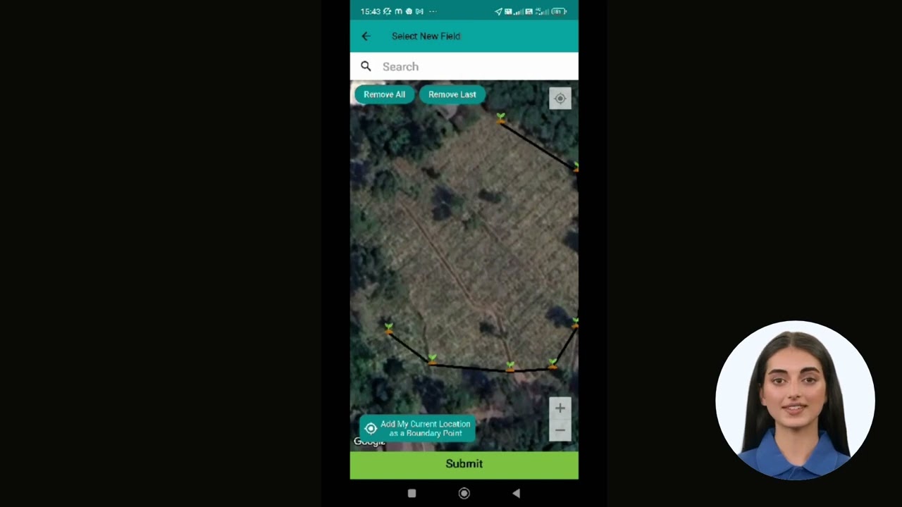
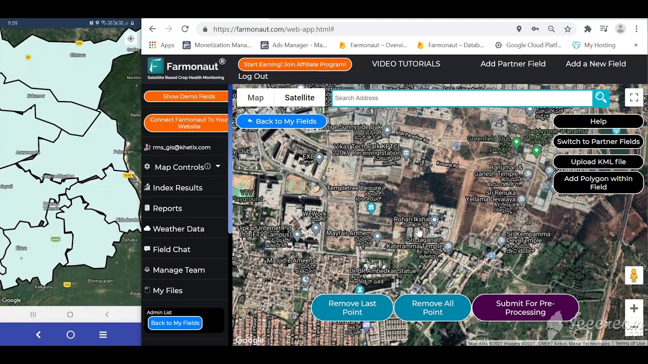
1. Field Mapping and Soil Sampling: Laying the Groundwork for Precision
Field mapping, empowered by GPS in agriculture, allows us to generate detailed field maps showing soil types, moisture levels, and variable crop health.
By integrating GPS data with GIS (Geographic Information Systems), we can:
- Accurately delineate field boundaries and specific crop areas
- Highlight variations in soil composition, nutrient content, and moisture
- Identify spots with low yield or underperforming crops for targeted treatments
This soil mapping and sampling approach enables systematic soil sampling across variable field conditions. We collect samples precisely by marking GPS coordinates, optimizing fertilizer application and resource management for every zone. The result is minimal input waste and improved crop performance.
Platforms like Farmonaut make this possible at scale with satellite-based NDVI and moisture mapping delivered directly to your smartphone, granting farmers real-time, actionable insights.
2. Machinery Guidance and Automation: The Rise of Autonomous Farm Equipment
Autonomous farm machinery equipped with GPS guidance is transforming how we work the land. From GPS-guided tractors to sophisticated John Deere 8R autonomous systems, machines are now capable of:
- Navigating fields with centimeter-level accuracy
- Operating along pre-programmed paths for planting, spraying, and harvesting
- Reducing operator fatigue and labor-intensive errors
- Minimizing equipment overlaps and missed spots, saving precious fuel and time
This technology not only addresses labor shortages but also ensures repeatable, efficient, and high-quality field operations—all while conserving resources and reducing costs.
With brands like John Deere integrating artificial intelligence and machine learning alongside GPS, machinery keeps getting smarter, adapting to field conditions in real time.
3. Precision Planting and Crop Management: The Seeds of Success
Through precision planting driven by GPS, we achieve optimal seed placement and spacing—foundations for improving yield and crop uniformity. The advantages include:
- Consistent seed depth and row placement: Maximizes germination rates
- Uniform crop emergence: Enhances sunlight distribution and nutrient competition
- Variable seed rate adjustment: Based on real-time soil and moisture data
Furthermore, crop management systems integrated with GPS can:
- Monitor plant health, pest outbreaks, and water stress
- Provide real-time insights to guide interventions—whether adjusting irrigation or applying targeted pesticides
Platforms like Farmonaut power this transformation by combining satellite imagery with AI-driven crop and soil monitoring, delivering instant advisories that help us reduce resource usage per hectare and increase productivity.

4. Smart Irrigation Management: Every Drop Counts
Water scarcity continues to challenge agriculture worldwide. GPS-integrated irrigation systems let us:
- Map fields by moisture content and plant requirements
- Apply precision irrigation management—delivering the right amount of water, to the right place, at the right time
- Integrate with soil sensors and satellite data for dynamic, automated scheduling
The outcomes are clear: we conserve water resources, minimize runoff, and nurture sustainable farming practices that benefit both productivity and the planet.
Farmonaut’s NDVI-based water stress maps are especially useful for identifying drought-prone areas or overwatered sections. For users interested in specialized farm management for large or multi-location fields, the Agro-Admin App is designed to simplify monitoring and irrigation scheduling across holdings of any scale.

5. Livestock Tracking and Management: Keeping Herds Efficient and Secure
Beyond crops, GPS technology is vital for livestock tracking and management. With GPS collars and tags, we can:
- Pinpoint the real-time location, activity, and health of each animal
- Prevent loss and theft through geofencing alerts
- Optimize grazing management, preventing overgrazing in specific areas
- Gather behavioral data for improved animal health monitoring
This digital management reduces human labor, strengthens biosecurity, and assures efficient resource allocation across large pastures or ranches.
Also, for agricultural enterprises integrating food supply traceability, Farmonaut’s product traceability solution utilizes blockchain to give end-to-end transparency—helping us build trust and meet regulatory standards seamlessly.
6. Real-Time Monitoring and Decision-Making: Empowering Data-Driven Farming
Agricultural GPS systems communicate with powerful networks of IoT sensors and farm management software, transforming the decision-making process.
Key advantages include:
- Access to instant updates on weather, soil conditions, and equipment performance
- Immediate alerts for anomalies: low moisture, pest surges, machinery faults, or changing field conditions
- Centralized dashboards to analyze farm conditions across all areas—from field level to enterprise-wide views
This farm data management produces actionable information, so we can solve problems in real time, protect our crops from risks, minimize losses, and stay ahead in an increasingly competitive landscape.
In the context of sustainability, Farmonaut’s carbon footprinting tool further ensures that each decision we make aligns with our environmental goals, letting us track, review, and reduce our emissions footprints over the season.
7. Variable Rate Application (VRA) and Yield Mapping: The Art of Optimization
Perhaps the most remarkable application of agricultural GPS systems is variable rate application in farming (VRA). Leveraging GPS and precise mapping:
- Fertilizers, pesticides, and seed rates are adjusted for each micro-zone in the field
- Inputs are minimized in high-fertility areas and increased only where needed
- Waste drops dramatically, crop health improves, and environmental impacts are reduced
Additionally, crop yield mapping tools record every pass of the harvester, logging yield, moisture, and other variables at each GPS coordinate.
- Post-season, we can create visual maps to reveal our most and least productive areas
- The historic yield data underpins planning and optimization for future plantings, crop rotations, and management strategies
All these insights are synchronized through automated data management systems—like those offered by Farmonaut—keeping your records secure, accessible, and ready for analysis season after season.
Comparing the 7 GPS Benefits in Agriculture
To help you visualize the immense value that each GPS-powered practice brings to farming, we’ve compiled a comprehensive comparison table. Assess the impact on yield, cost, resource savings, and sustainability for every major benefit discussed—your guide to prioritizing technology investments for transformative results.
| GPS Feature | Estimated Yield Increase (%) | Resource Savings (%) | Potential Cost Reduction (%) | Impact on Sustainability | Example Application |
|---|---|---|---|---|---|
| Field Mapping & Soil Sampling | 10-15% | 15-25% (fertilizer, water) | 10-20% | High | Site-specific soil sampling; custom fertilizer grid maps |
| Machinery Guidance & Automation | 5-12% | 15-30% (fuel, labor) | 15-30% | Medium | Autonomous tractors for planting and harvesting |
| Precision Planting & Crop Management | 8-15% | 10-20% (seeds, water) | 10-18% | High | Varying seed rate and depth by zone |
| Smart Irrigation Management | 7-12% | 25-40% (water) | 12-22% | High | Zonal irrigation based on soil moisture |
| Livestock Tracking & Management | Not direct (health-related 3-8%) | 20-25% (labor, loss) | 8-15% | Medium | GPS collars for grazing optimization |
| Real-Time Monitoring & Decision-Making | 5-8% | 10-20% (inputs, downtime) | 10-15% | High | IoT sensors for weather, pests, equipment |
| Variable Rate Application & Yield Mapping | 10-20% | 15-35% (fertilizers/pesticides) | 15-25% | High | GPS-based VRA; yield mapping during harvest |
Farmonaut: Making Precision Agriculture Affordable, Accessible, and Scalable
What sets Farmonaut apart in the realm of precision farming technology? Our mission is simple yet powerful: to democratize precision agriculture and deliver actionable data to farmers all over the world—without the traditional high equipment costs or technical barriers.
Our approach includes:
- Satellite-Based Crop Health Monitoring: We combine multispectral satellite imagery with AI to track vegetation health, soil moisture, and environmental variables daily.
- AI-Driven Advisory Systems: Jeevn AI analyzes dynamic crop and field data to issue personalized advisories for farmers on mobile and web.
- Blockchain-Based Traceability: Ensures end-to-end product journey transparency and food chain integrity.
- Fleet & Resource Management: Fleet management tools optimize machinery usage and enhance operational safety—this is essential for modern enterprises and contractors.
- Carbon Footprinting for Sustainability: High-impact carbon monitoring with actionable insights to reduce emissions and operate efficiently.
- Secure and Scalable Data Management: Our platform is cloud-based, API-accessible (API | Developer Docs), and supports everyone—from independent farmers to large enterprises.
- Real-Time Crop, Soil, and Water Monitoring: Data is consolidated on a single dashboard, enabling instant analysis and troubleshooting.
- Crop Loan & Insurance Verification: Satellite verification for insurance and credit risk reduction—improving access to finance while decreasing fraud risk.
- Large-Scale and Plantation Management: Agro-Admin App is tailor-made for organizations and managers handling complex, multi-location field operations.
All these benefits are delivered at an affordable, subscription-based model—so that farms of every size can unlock the potential of advanced agricultural GPS systems.
To learn more about our subscriptions, view pricing options below:
Challenges and Considerations for Agricultural GPS Systems
Despite the impressive advantages, adopting GPS in agriculture comes with unique challenges that we must address:
- Initial Investment: High-quality GPS equipment and integration may entail significant upfront costs. However, future savings and increased yields can quickly offset this. With providers like Farmonaut utilizing satellite and cloud-based solutions, thankfully, these barriers continue to drop each year.
- Technical Expertise: Farmers and agri-professionals must acquire some level of digital literacy and be comfortable with new technologies. Training and responsive support are crucial for maximizing value.
- Data Management: The vast quantity of farm data generated requires user-friendly management platforms for secure storage, historical analysis, and quick retrieval.
- Connectivity: In regions with poor internet coverage, real-time data transfer between field equipment, central platforms, and satellites may pose hurdles. Offline-first software and mobile-first access remain vital for inclusivity.
The Future of GPS Technology in Agriculture
As digital transformation expands, the next chapter of precision agriculture will be shaped by even greater integration between GPS technology, AI, IoT, and machine learning. We anticipate revolutions in:
- Smallholder inclusivity: Affordable, user-friendly GPS-powered apps for growers in all markets
- Full-farm automation: Drones, robotics, and AI-managed fleets working autonomously across varied terrain and weather
- Hyper-local weather & soil analytics: Precision will reach sub-meter scales, allowing interventions at the plant level
- Environmental reporting: Real-time, regulatory-compliant documentation for carbon, water, and biodiversity metrics
- Seamless supply chain transparency: Blockchain-enabled traceability from field to fork, building trust and market access
Farmonaut is at the forefront—namely, by offering cross-platform, API-enabled satellite solutions, we make it easy for farmers, agri-enterprises, and institutions to plug in, scale up, and participate in the future of data-driven farming.
FAQs on Agriculture GPS Systems
What is GPS in agriculture?
It refers to the use of the Global Positioning System in farm operations for mapping, tracking, machinery automation, and precision resource management. GPS allows us to improve accuracy, productivity, and sustainability in all areas of farming.
What is the role of GPS-enabled precision farming technology?
GPS-powered precision farming technology enables us to perform field mapping, autonomous machine guidance, variable rate application, and yield monitoring—resulting in higher yields and lower input costs while reducing waste and environmental impact.
How does variable rate application in farming work?
Using GPS and field maps, applicators deliver customized rates of fertilizer, pesticides, or seeds only where needed. This avoids over-application, saves resources, and increases overall crop performance.
What is crop yield mapping?
During harvest, yield monitors combine with GPS to record yield and other variables at specific field locations. The resulting yield maps reveal productive and underperforming areas for targeted management.
Can small farmers benefit from GPS technology?
Yes! Affordable, subscription-based, and mobile-accessible solutions like those from Farmonaut put the power of GPS data, soil mapping, irrigation monitoring, and more into the hands of individual farmers everywhere.
How does GPS support sustainability in agriculture?
By optimizing every input—water, fertilizer, fuel, labor—GPS-enabled farming protects natural resources, reduces chemical runoff, and supports regenerative practices for future generations.
Conclusion: Embracing GPS for Sustainable, Profitable Farming
GPS technology has rightfully become the backbone of precision agriculture. The fusion of real-time data, advanced AI, satellite imagery, and autonomous machine guidance is transforming how we approach every stage of the growing season.
Farmonaut stands at this intersection—not as a marketplace, equipment dealer, or regulatory agency—but as your technology partner offering advanced satellite-powered farm management for all. Together, we can:
- Adopt cost-effective tools that maximize productivity and sustainability
- Turn complex data into easy, actionable insights
- Track and optimize crop, soil, water, and livestock variables—no matter your farm’s size or location
- Build supply chain transparency and trust
- Secure better access to insurance, financing, and global markets
As we face the challenges and opportunities ahead, let’s continue to leverage the shockingly powerful benefits of agricultural GPS systems. With the right blend of knowledge and technology, the future of farming is more sustainable, profitable, and resilient than ever.


