

DJI Fly Mapping, Geo, LiDAR & Terra Drones for Topo Ag: How 2025’s Top Technologies Are Revolutionizing Agriculture
“LiDAR-equipped drones can map up to 200 hectares of farmland per flight for precise topographical agriculture analysis.”
- Introduction: Mapping the Future of Agriculture in 2026 and Beyond
- The Need for Precision Mapping in Modern Agriculture
- DJI Fly Mapping: Accessible Flight Planning for Data-Driven Farms
- DJI Geo Maps: High-Resolution Geospatial Intelligence
- LiDAR Mapping Drones: 3D Terrain for Sustainable Growth
- Topographic Mapping Drones: Microtopography & Mechanized Farming
- DJI Terra Agriculture: Actionable Analytics for the Agri-Future
- How Farmonaut Empowers Satellite-Powered Agriculture
- Comparative Table: Advanced Drone Mapping Technologies
- Practical Applications: Maximizing Crop Yields & Reducing Resource Waste
- Sustainability, Environment & Regulation: Responsible Topo Ag
- Top 5 Smart Strategies for Drone-Based Agricultural Mapping
- Expert Callouts: Insights, Tips, & Investor Highlights
- Multimedia: Satellite, Drone, and AI in Action
- FAQ: Your Most Pressing Questions, Answered!
Introduction: Mapping the Future of Agriculture in 2026 and Beyond
The agricultural landscape is experiencing a phenomenal transformation powered by the convergence of drone mapping, geospatial intelligence, LiDAR, and sophisticated data analytics. As we step into 2026, advanced drone-based mapping solutions—particularly from DJI—are making topographic agriculture more precise, efficient, and sustainable than ever before. The adoption of DJI Fly Mapping, DJI Geo Maps, LiDAR mapping drones, topographic mapping drones, and DJI Terra Agriculture is revolutionizing not just farm productivity, but also entire environmental and land management paradigms.
These technologies are now at the very heart of transforming how farmers and agronomists assess land, monitor crops, manage resources, and address challenges posed by climate change and global food demand. In this comprehensive blog, we will examine:
- How DJI Fly Mapping and DJI Geo Maps are enhancing field-level accuracy through user-friendly drone flight planning
- The rise of LiDAR mapping drones for detailed 3D terrain models—enabling precision in irrigation, soil, and land use optimization
- The essential role of topographic mapping drones in mechanized and large-scale farming operations
- How DJI Terra Agriculture brings together layers of drone-collected data for insightful, actionable analytics
- Why satellite-based platforms like Farmonaut are indispensable for scalable, cost-effective, and real-time agricultural monitoring
From elevation data and crop health monitoring to reducing water wastage and preventing soil runoff, let’s journey through the cutting-edge of mapping technologies that are empowering the world’s farmers—today and tomorrow.
“Geo-mapping drones process over 1 million data points per hectare, enabling highly detailed agricultural field assessments.”
The Need for Precision Mapping in Modern Agriculture
The global pressure on farming has never been greater. Arable land is scarce, resources are limited, and erratic weather patterns demand smarter strategies. Traditional field assessment and monitoring methods have become too slow, expensive, or inaccurate to keep pace with this changing landscape. Here’s why precision mapping solutions like DJI Fly Mapping, LiDAR, and Geo Maps now dominate the 2026 agricultural conversation:
- ✔ Accurate Land Assessment: Traditional survey methods lack the spatial resolution now possible through drone and satellite mapping.
- 📊 Data Insight: Drones and satellites enable analysis of precise field microtopography, soil conditions, and vegetation status across vast areas.
- ✔ Maximizing Yields: Early identification of pest infestations, nutrient deficiencies, or hydrological needs allows for interventions that can improve yields by up to 20%.
- ⚠ Risk or Limitation: Ground truthing may still be required to calibrate advanced sensors for highly variable regions.
- ✔ Reducing Inputs & Waste: Targeted input application based on real-time maps minimizes overuse of water, fertilizer, and pesticides, thus reducing operational costs and environmental impact.
This is why advanced mapping—powered by drone flight, LiDAR, and satellite modeling—is the bedrock of the future of precision agriculture in 2026 and beyond.
DJI Fly Mapping: Accessible Flight Planning for Data-Driven Farms
At the very heart of modern agricultural mapping is DJI Fly Mapping—a robust yet user-friendly software that enables streamlined automated drone missions for high-precision data collection. By 2026, this tool has become the industry standard for farmers seeking rapid, scalable, and affordable land assessments.
Key Features of DJI Fly Mapping
- ✔ Simplified Mission Planning: Intuitive interface for flight paths, altitude, and camera settings
- ✔ Automated Flight Execution: Drones fly pre-programmed routes for consistent and repeatable data capture
- ✔ Real-Time Feedback: Live mapping and error alerts on the field
- ✔ Rapid Data Upload: Raw drone imagery instantly accessible for processing in DJI Terra Agriculture
By integrating DJI Fly Mapping into daily farm routines, users can now obtain up-to-date maps of their farmlands, enabling analysis of crop health, soil conditions, and irrigation layouts with remarkable precision.

How DJI Fly Mapping Transforms Field Operations
- Flight Planning: Users define waypoints and coverage for specific fields or entire estates
- Automated Flight Missions: Drones execute patterns to cover every row while optimizing battery and time
- Data Collection: High-resolution aerial imagery is gathered under consistent lighting and environmental conditions
- Data Integration: Seamless upload to DJI Geo Maps, DJI Terra Agriculture, and compatible third-party analytics platforms



DJI Geo Maps: High-Resolution Geospatial Intelligence in Agriculture
DJI Geo Maps elevates mapping outcomes by providing high-resolution geospatial data essential for topographic assessment, zoning, and real-time field exploration. When DJI Fly Mapping missions are combined with Geo Maps, users gain access to both visual and analytical layers of information, paving the way for truly data-driven agriculture.
- ✔ Up-to-Date Orthomosaic Maps: Stitch together hundreds of aerial drone photos for full-field overviews
- ✔ Layered Data Analysis: Crop health, soil moisture, and elevation layers available for simultaneous visualization
- ✔ Temporal Comparison: Compare season-over-season changes to detect patterns in crop performance or land degradation
- ✔ Sharing & Collaboration: Geo-referenced maps and insights easily shared among farmers, agronomists, and stakeholders
Key Insight:
DJI Geo Maps processes more than 1 million data points per hectare, enabling highly detailed farm-level analysis for precision agriculture and resource management.
By leveraging DJI Geo Maps and seamless integration with DJI Fly Mapping, farmers and field agents are empowered to conduct assessment and monitoring workflows on a totally new scale—with unprecedented accuracy and responsiveness.

DJI Geo Maps: Beyond Traditional Photogrammetry
- ✔ Geo-Referenced Data: Every image is linked to a precise latitude, longitude, and altitude for holistic record keeping
- ✔ Elastic Scalability: Easily scale from smallholdings to massive estates—perfect for large scale farm management
- ✔ Actionable Alerts: Instant notifications about emerging issues—like early pest infestations, dry patches, or equipment anomalies
- ✔ Sustainable Practices: Ensures responsible field planning, zoning, and long-term land conservation
LiDAR Mapping Drones: 3D Terrain Models for Sustainable Growth
One of the biggest advances of the mid-2020s, LiDAR mapping drones (Light Detection and Ranging) have rapidly moved into the essential kit for topographic mapping in agriculture. Unlike traditional photogrammetry, LiDAR mapping drones emit laser pulses that bounce back from the ground and vegetation, building detailed, 3D models of terrain, canopies, and even root structures beneath dense crops.
- ✔ High-Resolution DEMs: Produce Digital Elevation Models and contour maps for even the most complex fields
- ✔ Penetration Ability: See through vegetation for a clear “bare earth” perspective, critical for soil erosion and irrigation studies
- ✔ Rapid Area Coverage: Map 100+ hectares in a single flight
- 📊 Environmental Monitoring: Track changes in land structure, soil health, water flow, and biodiversity over time
- ✔ Enables Sustainable Practices: Facilitates contour farming, buffer zone, and flood risk analysis
The ability of LiDAR mapping drones to generate detailed digital terrain models (DEMs) is crucial for optimizing irrigation layouts, reducing water wastage, and preventing runoff that can degrade valuable agricultural soil quality.

Topographic Mapping Drone: Microtopography & Mechanized Farming
Topographic mapping drones build on LiDAR’s insights to deliver an almost surgical understanding of land elevation and subtle structural variations. For farms relying on heavy machinery or precision equipment, such drones ensure every planting, fertilization, and harvesting action is optimized for the land’s microstructures.
- ✔ Field Micro-Variability: Identify sub-field changes atop otherwise uniform plots
- ✔ Cost Efficiency: Reduce unnecessary passes with machinery—saving fuel and time
- ✔ Infrastructure Planning: Position farm roads, drainage, silos, and more with minimal productive land disruption
- ✔ Flexible Assessment: Layer topographic data atop crop health and soil datasets for more holistic strategies

Benefits from Topographic Drone Mapping
- ✔ Optimize Irrigation: Water delivery aligns with slope and catchment for minimal runoff
- ✔ Contour Farming: Reduce soil erosion and nutrient loss, improving long-term yields
- ✔ Boost Mechanization: Lower operational costs by matching machinery to actual field elevation profiles
- ✔ Sustainability: Enable regenerative farming strategies to enhance soil health and carbon sequestration

DJI Terra Agriculture: Actionable Analytics for the Agri-Future
The data captured by DJI Fly Mapping, DJI Geo Maps, LiDAR drones, and topographic mapping drones is only as valuable as its interpretation. Enter DJI Terra Agriculture—the revolutionary processing software that turns terabytes of raw aerial imagery and laser scans into actionable insights.
- ✔ Advanced Data Processing: AI-driven conversion of drone data into 3D orthomosaics, NDVI, and yield models
- ✔ Cultivar-Specific Analytics: Tailored health insights and productivity forecasts for each crop type
- ✔ Scenario Simulations: Predict outcomes based on different seeding, irrigation, or fertilization strategies
- ✔ Actionable Decision Support: Send recommendations directly to farm machinery or advisory platforms
In 2025 and beyond, DJI Terra Agriculture becomes the hub for combining mapping and drone data, with predictive AI modeling that supports quick, proactive decisions—from pest and disease alerts to water-saving schedules and yield optimization.
How Farmonaut Empowers Satellite-Powered Agriculture
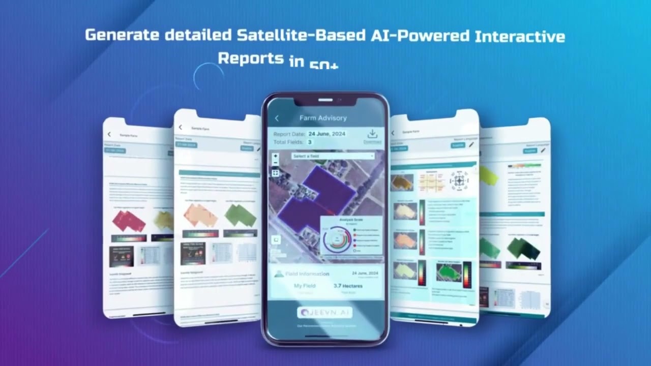
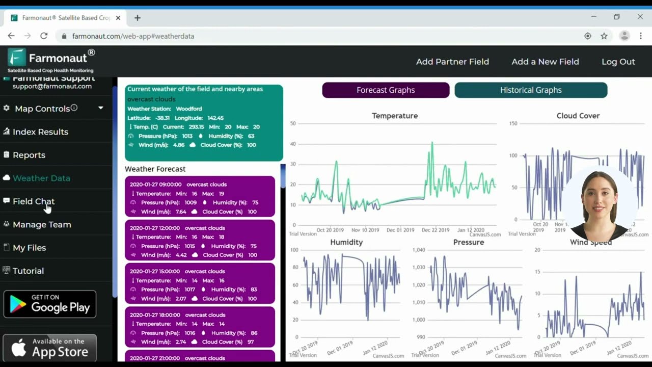
While drone mapping tools excel at field-level (micro) analysis, Farmonaut’s satellite-based solutions scale this intelligence to regions and countries. We provide affordable, real-time crop monitoring, AI-based advisory systems, blockchain-based traceability, and comprehensive resource management—all delivered through an intuitive web/browser, Android, and iOS app, or via API for businesses.
- ✔ Satellite-Based Monitoring: Multispectral imagery pinpoints vegetation health, soil conditions, and infrastructure assessment at wide scale
- ✔ Real-Time Advisory: Jeevn AI platform delivers weather forecasts and tailored management tips via satellite data
- ✔ Blockchain Traceability: Ensure secure, transparent product journeys and combat fraud in supply chains
- ✔ Fleet & Resource Management: AI-driven logistics for optimizing vehicle and equipment deployment for agriculture and mining
- ✔ Environmental Impact Tracking: Carbon footprint and resource use monitoring to underpin sustainable field practices
Our modular platform can flexibly support individual users, businesses, governments, and financial institutions—democratizing access to satellite insights for decision-makers at every scale.
Discover more about how our carbon footprinting solutions
can transform your environmental sustainability management, or
explore blockchain traceability for agri-commodities and mining. Our AI-enabled fleet management
service supports logistics and resource optimization for large-scale operations.
We also support the fastest-growing demand for large-scale farm management with advanced monitoring and API integration (API, API Developer Docs).
Comparative Table: Performance of Advanced Drone Mapping Technologies
| Technology Type | Main Function | Estimated Mapping Accuracy (cm) | Area Coverage/Flight (hectares) | Data Processing Time (hours) | Potential Crop Yield Improvement (%) |
|---|---|---|---|---|---|
| DJI Fly Mapping | Automated flight planning & aerial data collection | 3–5 | 80–120 | 2–4 | 10–15 |
| DJI Geo Maps | High-resolution geospatial mapping & analysis | 2–3 | 60–100 | 3–5 | 15–20 |
| LiDAR Mapping Drone | 3D terrain, soil, and canopy modeling | 1–3 | 150–200 | 2–6 | 20–25 |
| Topographic Mapping Drone | Microtopography & infrastructure planning | 1–2 | 80–120 | 3–6 | 12–18 |
| DJI Terra Agriculture | AI-powered data processing & decision support | 2–4 | N/A (depends on source) | 1–2 | 15–22 |
Practical Applications: Maximizing Yields & Reducing Resource Waste
To maximize the benefit of DJI drone mapping, synchronize drone flights with latest weather and satellite data via tools like AI-powered plantation & forest advisory platforms for fully integrated field management.
- ✔ Crop Health Monitoring: Detect nutrient deficiencies, diseases, and early-stage pest infestations that would otherwise go unnoticed—allowing for timely interventions and reduced dependence on harmful chemicals.
- 📊 Yield Prediction: Combine NDVI imagery and digital elevation data to model future yields and optimize planting/fertilization strategies.
- ✔ Resource Management: DJI Terra processes drone & LIDAR data to recommend variable-rate seeding, irrigation, and pesticide usage, drastically reducing costs and increasing efficiency.
- ✔ Disaster Mitigation: Identify areas vulnerable to erosion, flooding, or drought for preventive action at the field, farm, or regional scale.
- ✔ Infrastructure Planning: Topographic drone data assists with siting of new roads, silos, and drainage, ensuring minimal productive land loss.
📍 Major Benefits of Drone-Based Agri Mapping
- ✅ Enhanced Accuracy: Drone and LiDAR mapping ensures sub-centimeter precision for decisions in agriculture.
- ✅ Boosted Efficiency: Automation streamlines flight missions, data collection, and processing—reducing labor demands and human error.
- ✅ Cost Savings: Integrated mapping data leads to smarter input usage and lower operational costs.
- ✅ Proactive Management: Early detection enables timely action on pests, disease, and water stress.
- ✅ Sustainability: Fact-driven farming supports responsible stewardship of land and water resources.
🚩 Watch Points: Common Pitfalls in Agri Drone Mapping
- ⚠ Data Overload: Without AI-powered processing (like DJI Terra or satellite analytics), raw data may overwhelm most users.
- ⚠ Regulatory Compliance: Operating drones may require licenses or permits depending on your region.
- ⚠ Calibration Needs: Sensors and LiDAR regularly need recalibration in diverse geographies.
- ⚠ Connectivity Issues: Real-time data upload may require robust field internet or 4G/5G access.
- ⚠ Training Essentials: Staff need periodic skill upgrades to keep up with drone and GIS software updates.
Sustainability, Environment & Regulation: Responsible Topo Ag
Drone mapping and sustainability tools are positioned at the intersection of global food security and environmental compliance. By 2026, regulatory frameworks increasingly require soil and water conservation reporting—empowering businesses using drone, LiDAR, and advanced analytics solutions.
Sustainability isn’t just best practice, it’s becoming a regulatory requirement. Using LiDAR mapping drones, DJI Fly Mapping, and DJI Terra to generate compliance-ready data gives farmers a strategic edge in accessing financial products, carbon markets, and green supply chains.
Discover Farmonaut’s satellite-verified crop loan and insurance services as well as large-scale farm management for cost-effective, sustainable growth.
Many farms collect drone/geo data but lack a robust analytics or AI platform to convert raw imagery into actionable strategies—limiting their ROI and sustainability gains.
Top 5 Smart Strategies for Drone-Based Agricultural Mapping
- Automate Flight Schedules: Use DJI Fly Mapping to routinely collect fresh data during key crop stages for real-time decision making.
- Layer Data Sources: Combine LiDAR and optical imagery for a 360-degree view of soil health, crop growth, and water movement.
- Scale with Satellite: Augment field data with Farmonaut’s wide-scale satellite monitoring for regional risk forecasting and benchmarking.
- Integrate Predictive Analytics: Harness DJI Terra Agriculture to anticipate outcomes—whether optimizing fertilizer use or testing different irrigation layouts digitally before deploying them in the field.
- Focus on Sustainability Tracking: Make use of drone and LiDAR-derived DEMs for carbon reporting, erosion monitoring, and compliance with new environmental policies.
The integration of drone mapping, LiDAR, and AI analytics will be indispensable for agri-businesses seeking carbon credits and supply chain sustainability certifications by 2030.
Expert Callouts: Insights, Tips, & Investor Highlights
When synchronizing satellite and drone data platforms, ensure compatibility with leading farm management APIs, such as those offered by Farmonaut, for seamless analysis and reporting.
Global growth in digital agriculture is expected to surpass $25B by 2030, with drone- and LiDAR-based mapping among the key verticals driving the agri-tech revolution.
Farmonaut: Flexible Satellite Services for Agri, Mining, and Beyond
Multimedia: Satellite, Drone, and AI in Action
FAQ: Your Most Pressing Questions, Answered!
Q1. What is DJI Fly Mapping, and how does it transform agriculture?
DJI Fly Mapping is a leading drone flight planning and data collection software. It streamlines automated drone missions—enabling precision field mapping, accurate crop monitoring, and efficient land assessment. By automating aerial data collection, it helps farmers and agronomists achieve remarkable accuracy and efficiency.
Q2. How are LiDAR mapping drones different from traditional mapping drones?
LiDAR mapping drones use laser pulses for 3D modeling of terrain and vegetation—even beneath dense canopies. Unlike photogrammetry, LiDAR captures detailed elevation and structural data, which is invaluable for water management, soil erosion prevention, and planning contour-based cultivation strategies.
Q3. What role does DJI Terra Agriculture play in the drone data ecosystem?
DJI Terra Agriculture is specialized software for processing drone and LiDAR data into actionable insights—such as orthomosaic maps, NDVI indices, and predictive models for yield and growth. It uses AI to enable proactive, data-driven decisions in modern agriculture.
Q4. What are the benefits of integrating satellite technology platforms like Farmonaut with drone mapping?
Farmonaut’s satellite-based platform provides wide-area, real-time monitoring—supplementing drone-derived insights at the field level with regional and temporal data. This dual-layered approach enables comprehensive decision-making for agribusinesses, individual farmers, and governments.
Q5. Can these technologies help with sustainable farming and environmental compliance?
Yes. Drone mapping tools and platforms like DJI Terra Agriculture generate data that support conservation agriculture, enable carbon footprint tracking, help optimize resource use, and facilitate regulatory compliance. This makes them crucial for businesses and governments focused on sustainability and long-term productivity.
Summary:
In 2025 and beyond, the integration of DJI Fly Mapping, DJI Geo Maps, LiDAR mapping drones, topographic mapping drones, and DJI Terra Agriculture stands at the forefront of agricultural innovation. These advanced technologies empower the agricultural sector with scalable, efficient, and ultra-precise tools for land management, crop health monitoring, water conservation, and regulatory compliance.
With the ongoing evolution of hardware, software, and satellite analytics—like those provided by Farmonaut—the agriculture industry is on the cusp of a new era of sustainable productivity. Farmers equipped with these tools can not only expect higher yields and lower costs, but also a more resilient relationship with the environment, successfully navigating the challenges of modern agri-business in the years to come.

 Godrej Agrovet
 Hayleys Agriculture
 Linx Agritech
 Adinet
 Save Your Soils
 GalaxEye Space
 Grandstream Algérie
 XOS Realty
 Geospatial Lab Africa
 Agro La Gándara
 HIPSAC
 ZOL Zimbabwe
 Juligerm
 AdBio
AdBio MISE Maroc
 NWNS
NWNS Red August Group
 Farm Inc
 WeMe Global
 Agrotoken
 Blue BearX
 Insignito
 DnCubed
 Indosistim Teknologi
 Liquify Digital
 CU Foods
 BeyondTech Global
 Rouge VC
 AgroRisk
 Oath Inc
 Esri North East Africa
 MDCV UK
 Etech Consulting Madagascar
 Vestlandsforsking
 WB Dev
 Sama Premium
 Tres Valles
 Blickwinkel
 Agricultural Credit Policy Council
 eKGIS
eKGIS Mostas Tech
 Andex
Andex Deluxe Conseil
 WICO
WICO Chimera Innovation
 SkyHarvest
 Teledarbas
 Exurbia Geospatial
 FieldZero
