

Gold exploration · Nunavut
Gold mines in Nunavut: who owns Hope Bay, Goose and Meliadine, and how a claim works on federal and Inuit land
Key takeaways
- Every operating gold mine in Nunavut: Meliadine and Meadowbank (with Amaruq) belong to Agnico Eagle; Goose in the Back River district belongs to B2Gold.
- Hope Bay: Agnico Eagle bought it with TMAC in February 2021, paused mining that September and approved a roughly US$2.4 billion rebuild on May 19, 2026.
- Claims are federal: you need a licence to prospect, then you select grid units online in the Nunavut Map Selection (NMS) system. There is no ground staking.
- Inuit Owned Lands: Nunavut Tunngavik Incorporated (NTI) manages subsurface rights on its parcels; the three Regional Inuit Associations manage surface access.
- Satellites: tundra exposes a lot of rock, but lichen and the short snow-free window limit what optical data can read.
In this article
- Which gold mine in Nunavut is operating, and who owns it?
- Hope Bay, Nunavut: from care and maintenance to a construction decision
- How to hold a gold claim in Nunavut: licence, map selection and yearly work
- Who owns the minerals: Crown land, Inuit Owned Lands and the Nunavut Agreement
- Agnico Eagle in Nunavut: Meadowbank, Amaruq and Meliadine
- Back River, Committee Bay and Lupin: the rest of the Nunavut gold map
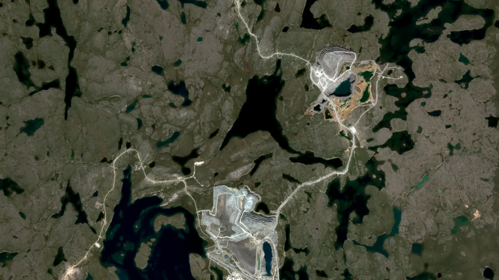
- What satellites can and cannot see around a gold mine in Nunavut
- Buying into Nunavut gold: a checklist for juniors and investors
- Gold mine in Nunavut: frequently asked questions
Every operating gold mine in Nunavut today belongs to Agnico Eagle (Meliadine, and Meadowbank with its Amaruq satellite) or B2Gold (Goose, in the Back River district), and Agnico Eagle’s Hope Bay is the next one, with production targeted for 2030.
If you are looking for a gold mine in Nunavut, the list is short and the owners are large. Agnico Eagle runs Meliadine near Rankin Inlet and the Meadowbank complex north of Baker Lake, and in May 2026 it approved the redevelopment of Hope Bay in the Kitikmeot region. B2Gold, which bought Sabina Gold & Silver in 2023, has been producing at the Goose mine in the Back River district since 2025. Below that tier sit explorers such as Fury Gold Mines at Committee Bay, and old sites such as Lupin. For anyone thinking of holding ground nearby, the rules are unusual for Canada: mineral rights on most land are federal, administered by Crown-Indigenous Relations and Northern Affairs Canada (CIRNAC), while Inuit hold the minerals on about 2% of the territory and surface title on much more.
This goes one level deeper than our overview of gold exploration in Canada, which covers the Ontario and Quebec claim systems.
Which gold mine in Nunavut is operating, and who owns it?
Start with the numbers. Natural Resources Canada’s 2024 mineral production table credits Nunavut with 27,028 kilograms of gold, worth about C$2.84 billion in shipments. Only Ontario (69,687 kg) and Quebec (58,259 kg) reported more. Yukon and Saskatchewan figures are confidential in that table. In 2022 Nunavut reported 23,432 kg; in 2019 to 2021 and 2023 its figure was suppressed.
Chart
Nunavut was Canada’s third-largest reported gold producer in 2024
Gold quantity produced, kilograms. Yukon and Saskatchewan are confidential (x) in the table and not shown.
That output comes from very few places, and logistics shape every gold mine in Nunavut. B2Gold buys a year’s fuel for Goose at once and ships it in, Hope Bay has its own port at Roberts Bay and an airstrip that takes Boeing 737s, and Agnico Eagle builds the caribou migration into its production plan because it can disrupt haulage on the road between Amaruq and the Meadowbank mill. Mergers have also renamed or reassigned several assets over the past five years, so the table lists each gold mine in Nunavut and the leading projects with owners and statuses we confirmed this month from filings, company sites or government sources.
| Mine or project | Region | Owner (checked October 2026) | Status | Basis |
|---|---|---|---|---|
| Meliadine | Kivalliq, about 25 km north of Rankin Inlet | Agnico Eagle | Operating; commercial production since May 2019 | Agnico Eagle mine page and 2025 results |
| Meadowbank complex (Meadowbank mill, Amaruq: Whale Tail pit and underground) | Kivalliq, about 110 km by road north of Baker Lake | Agnico Eagle | Operating; mine life extended to 2030 | Agnico Eagle mine page and 2025 results |
| Hope Bay (Doris, Madrid with Patch 7, Boston) | Kitikmeot, about 125 km southwest of Cambridge Bay | Agnico Eagle | Construction approved May 2026; first gold expected 2030 | Agnico Eagle release, May 19, 2026 |
| Goose mine, Back River district | Kitikmeot | B2Gold (acquired Sabina Gold & Silver, April 2023) | Operating; commercial production from the start of Q4 2025 | B2Gold Q2 2026 MD&A; 2023 closing release |
| Three Bluffs, Committee Bay belt | About 180 km northeast of Meadowbank | Fury Gold Mines (100%) | Exploration; NI 43-101 resource dated September 2023 | Fury Gold Mines project page |
| Lupin | Kitikmeot, near Contwoyto Lake | Not confirmed (see note below) | Historic producer, not operating | Nunatsiaq News, 2013 |
The two producers now cooperate. In April 2026 B2Gold and Agnico Eagle agreed to a Nunavut collaboration agreement covering Arctic mining, logistics, exploration planning and environmental management, according to B2Gold’s second-quarter 2026 report.

▶ Arctic and subarctic gold exploration with satellite data, set in Alaska rather than Nunavut, but the terrain problems are the same (11:35). · 11:35
TMAC’s Doris mine at Hope Bay produced 475,331 ounces at an average 9.56 g/t before care and maintenance in 2021.
Hope Bay, Nunavut: from care and maintenance to a construction decision
Hope Bay is the project most people search for, and its history explains why. Exploration began in 1964, first for silver. BHP Minerals found the Boston, Doris and Madrid gold deposits in the 1990s; Miramar Hope Bay explored from 2000 to 2007, and Newmont carried the project until 2011. TMAC Resources bought it in 2013, built the Doris mine at about 2,000 tonnes a day and declared commercial production in 2017. Agnico Eagle then acquired TMAC in February 2021 and put the mine on care and maintenance in September 2021 to concentrate on drilling. All of this comes from Agnico Eagle’s May 19, 2026 release.
What Agnico Eagle approved for Hope Bay
Agnico calls Hope Bay the next large-scale gold mine in Nunavut. The decision rests on a preliminary economic assessment, which the company calls the 2026 Study. It describes an underground mine feeding a 6,000-tonne-a-day mill, with three mining fronts at start-up: Doris, and Madrid and Patch 7 within the Madrid deposit. Planned output is 400,000 to 435,000 ounces a year over an initial 11-year life, about 408,000 ounces on average. Initial development capital is put at roughly US$2.4 billion, including rebuilding the processing plant (the old mill has been dismantled), a 37-megawatt diesel power plant and about 33 kilometres of underground development. The company expects development from 2026 to 2029, first gold in 2030, and full design throughput in 2032.
Read the resource numbers carefully. The study is based on mineral resources, not reserves: 5.79 million ounces in the measured and indicated category (31.97 million tonnes at 5.63 g/t) and, separately, 3.33 million ounces inferred (17.33 million tonnes at 5.97 g/t). Agnico says the 11-year plan uses only about 55% of the measured and indicated ounces and 48% of the inferred ounces. The Boston deposit, roughly 50 km south of Madrid, is reported on its own at 1.01 million ounces indicated (5.48 million tonnes at 5.72 g/t) and 0.47 million ounces inferred (2.85 million tonnes at 5.14 g/t). Do not add these categories together, and do not treat a preliminary economic assessment as a reserve.
The property, the belt and the Inuit agreement
The land package covers about 1,951 square kilometres, roughly 80 km north to south and 20 km east to west, and mixes Crown mineral claims, Crown mining leases, a production lease and access agreements over Inuit Owned Lands. The deposits are orogenic gold tied to major deformation zones in the Hope Bay greenstone belt, and Agnico’s wider holding also takes in the adjacent Elu belt. The company plans more than US$100 million of exploration at Hope Bay over three years, including renewed drilling at Boston.
On permits, Agnico says the environmental permits and production lease needed for construction are in place, while water licence updates for the production phase are in progress. The Hope Bay Inuit Impact and Benefit Agreement with the Kitikmeot Inuit Association has been in force since 2015 and runs to 2035. Anyone tracking hope bay nunavut news should watch those water licence filings, which are public through the Nunavut Water Board.

▶ Why producers are paying up for long-life gold districts like Hope Bay: a documentary on the global race for new gold (10:44). · 10:44
How to hold a gold claim in Nunavut: licence, map selection and yearly work
Suppose you want ground next to a gold mine in Nunavut. On Crown land the process runs through CIRNAC, not a territorial ministry, because mineral rights there sit under the federal Territorial Lands Act and the Nunavut Mining Regulations (SOR/2014-69, current to September 21, 2026 on the Justice Laws site). The Mining Recorder’s Office in Iqaluit records the rights; royalties are handled separately by CIRNAC’s Petroleum and Mineral Resources Management Directorate.
Step one: a licence to prospect
According to CIRNAC’s page on exploration on Crown lands (modified February 2, 2024), you need a licence to prospect to explore on Crown land, record a claim or lease a recorded claim. Anyone aged 18 or over can apply, as can a company registered under the territorial or federal business corporations acts. The licence costs $5 for an individual and $50 for a corporation, and renewal by March 31 each year is free. You apply or renew in the NMS system.
Step two: select units in Nunavut Map Selection
Ground staking ended with the 2020 amendments. CIRNAC launched the online Nunavut Map Selection system on January 30, 2021, after a 90-day transition in which staking was banned and old staked claims were converted into grid-based “unit claims”. You need an account from the Mining Recorder’s Office. A claim is a block of contiguous units from a predefined grid, from 1 to 100 units, and it cannot enclose an unselected unit. Unit size varies with latitude between 10 and 25 hectares, averaging 18 hectares (about 44 acres), so a full 100-unit claim is roughly 1,800 hectares. Ground around an operating gold mine in Nunavut may already be held, so check the claim layer in the Nunavut Map Viewer first.
You pay a deposit of $45 per unit at selection, refunded once the Mining Recorder issues a certificate of work for at least that amount. The date the online application is received becomes the claim’s anniversary date. NMS flags units containing land not open for prospecting, such as cemeteries, parks, wildlife sanctuaries and subsurface Inuit Owned Lands; only the open part of such a unit is recorded, but the work requirement for the unit does not shrink.
Step three: yearly work, reports and extensions
A claim lasts up to 30 years if the work is done. Each year you spend at least that year’s requirement on every unit and file a report of work within 120 days of the anniversary. Fall short, and you can buy a one-year extension by depositing the shortfall, up to five times. Grouping up to 400 contiguous claims ($10 fee) lets work credits move across the group.
Chart
The work bill rises in steps: $45 a unit in year 1, $270 by year 21
Minimum cost of work per unit (or partial unit) each claim year, Nunavut Mining Regulations, Canadian dollars (C$).
Two limits catch people out. A claim gives no surface rights, and you cannot remove more than $100,000 of minerals from a single claim, other than samples for assay or evaluation, without taking it to lease. A lease (21 years, renewable) requires at least $1,260 of work per unit, which is ten years of the schedule. CIRNAC’s guide to the amended regulations (modified March 4, 2021) puts lease rent at $10 per hectare, or about $180 for an average 18-hectare unit.
Calculator
What will it cost to hold a Nunavut claim?
Enter your claim size and how long you plan to hold it.
- Claim area: 900 ha
- Claim area: 2,224 acres
- Deposit when you select the claim (C$, refundable): $2,250
- Average work per hectare per year (C$): $5.00
- Work due in the final year alone (C$): $6,750
- Licence to prospect (C$): $50
- Work per unit toward the C$1,260 lease threshold (C$): $450
- Share of the lease threshold reached: 36 %
Example values only, in Canadian dollars (C$). Assumptions: work requirements per unit by claim year (C$45 in year 1, C$90 in years 2 to 4, C$135 in years 5 to 7, C$180 in years 8 to 10, C$225 in years 11 to 20, C$270 in years 21 to 30), the C$45-per-unit deposit (refundable once a certificate of work is issued), licence fees of C$5 (individual) or C$50 (corporation) with annual renewal at no charge, and the C$1,260-per-unit work needed before a lease, as published by CIRNAC and the Nunavut Mining Regulations (SOR/2014-69, current to 2026-09-21). Units are capped at 100 and years at 30. Excludes land use permits, water licences, Inuit Owned Lands agreements, field costs and taxes. Confirm with the Mining Recorder’s Office before you rely on it.
With the defaults, fifty average units cover about 900 hectares and five years of minimum work costs $22,500, roughly $5 a hectare a year, before field and permitting costs. For licensing systems elsewhere, see our mining cadastre portal guide by country.

▶ From ore to doré: what happens after a claim becomes a gold mine in Nunavut or anywhere else, relevant to the mill rebuild planned at Hope Bay (10:34). · 10:34
Who owns the minerals: Crown land, Inuit Owned Lands and the Nunavut Agreement
Anyone planning a gold mine in Nunavut deals with land rules set by the Nunavut Agreement, which created the territory on April 1, 1999. Land falls into three classes: Crown land, Commissioner’s land and Inuit Owned Land (IOL). CIRNAC’s land and resource management overview explains the split. IOL can carry surface rights only, or surface and subsurface rights together. The Agreement gives NTI responsibility for land and resource management on IOL; NTI has delegated surface management to the Kitikmeot, Kivalliq and Qikiqtani Inuit Associations.
The scale is set out by NTI itself: Inuit own subsurface rights to 38,000 km² of the 356,000 km² of Inuit Owned Lands, according to an NTI release from March 2003. On those subsurface parcels you deal with NTI, which grants rights through mineral exploration agreements and mineral production leases, not with the Mining Recorder. Agnico Eagle’s Amaruq mine is an example: the company pays NTI a net-profits royalty under a mineral production lease, which its 2025 results call the “NTI Payment”.
Inuit hold subsurface title to 38,000 km² of the 356,000 km² of Inuit Owned Lands.
Surface access and benefit agreements
Where a Crown claim overlaps surface IOL, CIRNAC says you must get a surface access permit from the relevant Regional Inuit Association before going onto the ground; the Nunavut Surface Rights Tribunal can hear disputes. CIRNAC’s earlier guide adds that consent from the Designated Inuit Organization is still needed to prospect on IOL where the Crown holds the mining rights. Before a gold mine in Nunavut can start operating, the Regional Inuit Association and the company must sign an Inuit Impact and Benefit Agreement covering matters such as compensation, training, employment targets and royalties. Every operating gold mine in Nunavut has one; Hope Bay’s dates from 2015.
The permitting path
The Nunavut Agreement also created institutions of public government that sit between a claim and a mine. The Nunavut Planning Commission is the “single window”: you submit a project proposal and it rules on conformity with land use plans, within 45 days for exploration work that needs permits. The Nunavut Impact Review Board screens proposals and assesses larger projects, and a gold mine in Nunavut needs its Project Certificate before production can begin. The Nunavut Water Board licences water use and waste deposit on Crown land and IOL alike, while CIRNAC Lands issues land use permits on Crown land.
Infographic
The Nunavut path on Crown land, from licence to Project Certificate
- 1Licence to prospectC$5 for a person or C$50 for a company, through NMS.
- 2Select claim unitsSelect units online in NMS and pay a C$45-a-unit deposit.
- 3Planning checkIf permits are needed, the NPC checks conformity with land use plans in 45 days.
- 4Permits for the workGet a CIRNAC land use permit and an NWB water licence for the work.
- 5Work and reportDo the work and report its costs within 120 days of each anniversary.
- 6Lease and assessmentTake a lease, then NPC and NIRB assessment lead to a Project Certificate.
Agnico Eagle in Nunavut: Meadowbank, Amaruq and Meliadine
Meadowbank was the first mine Agnico Eagle built in Nunavut, reaching commercial production in March 2010. Together with Meliadine, its Nunavut operations produced 869,660 ounces in 2025, according to the company’s fourth-quarter 2025 results. With Hope Bay, Agnico says it aims to keep its Nunavut platform at 800,000 ounces to one million ounces a year.
Meadowbank and the Amaruq mine, Nunavut
The Meadowbank complex is about 110 km by road north of Baker Lake in the Kivalliq. Ore from Amaruq, a satellite open-pit and underground mine about 50 km from the Meadowbank site, travels by long-haul truck along a 64-km road to the Meadowbank mill. The Whale Tail pit at Amaruq reached commercial production in September 2019 and the Amaruq underground in August 2022. Agnico’s Meadowbank page lists proven and probable reserves of 1.5 million ounces at December 31, 2025, with 1.3 million ounces measured and indicated and 783,000 ounces inferred, reported separately.
Geologically, Amaruq is iron-formation gold. A study by researchers at the University of Quebec at Montreal, the Geological Survey of Canada and Agnico Eagle describes the Amaruq geology as Archean rocks of the Woodburn Lake Group (about 2.71 billion years old) in the Rae domain. At Whale Tail, gold sits with pyrrhotite and arsenopyrite in silicate-facies iron formation; at the nearby IVR zone it is mostly in quartz-carbonate veins. The Geological Survey of Canada’s lexicon describes the Woodburn Lake group as volcanic rocks, iron formation and related sediments.
In February 2026 Agnico approved a pit push-back that extends Meadowbank’s life by two years to 2030, adding about 740,000 ounces (21.2 million tonnes at 2.65 g/t) to the 2026 to 2030 plan. The Amaruq underground is expected to supply about 150,000 ounces a year from 2026 to 2028, and an underground-only plan beyond 2030 is under study, with early results due in 2027.

▶ How satellite screening and soil geochemistry combine on Canadian gold and copper ground (3:11). · 3:11
Meliadine, Nunavut
Meliadine sits about 25 km north of Rankin Inlet on the main gold-bearing fault system of the Rankin Inlet greenstone belt, which hosts seven gold deposits in its central 20 km. It became a producing gold mine in Nunavut in May 2019, when it reached commercial production, and produced 376,346 ounces in 2025. The mill averaged 6,441 tonnes a day in 2025, and Agnico guides to 380,000 to 400,000 ounces in 2026 from 2.37 million tonnes at 5.32 g/t. Agnico’s Meliadine page shows 3.6 million ounces of proven and probable reserves at the end of 2025, plus 2.2 million ounces measured and indicated and 2.5 million ounces inferred.
Chart
Meliadine climbs while Meadowbank tapers: guidance ranges by mine
Ounces of gold. Each row compares the 2025 actual with the low and high of the February 2026 forecast range for that year.
The chart makes the next few years clear. Meliadine’s guidance rises through 2028, while Meadowbank falls sharply in 2028 as it moves from mainly open pit to mainly underground. Meadowbank, the oldest gold mine in Nunavut still producing, is the one winding down, which is why the Hope Bay decision matters to anyone selling ground in the Kivalliq or Kitikmeot.
Back River, Committee Bay and Lupin: the rest of the Nunavut gold map
B2Gold’s Goose mine and the Back River district
B2Gold closed its acquisition of Sabina Gold & Silver on April 19, 2023, taking over the Back River Gold District, which the company then described as five mineral claim blocks along an 80 km belt, with Goose as the most advanced project. So anyone searching for a “Sabina gold mine in Nunavut” is now looking at B2Gold’s Goose mine. Goose achieved commercial production at the start of the fourth quarter of 2025, making it the newest gold mine in Nunavut. B2Gold credits the Kitikmeot Inuit Association with a central role in getting the mine built.
The ramp-up has been uneven. A fire in the crushing circuit on April 17, 2026 cut second-quarter output to 12,890 ounces (72,334 tonnes milled at 5.87 g/t, 93.9% recovery), and first-half production was 55,766 ounces. B2Gold narrowed its 2026 guidance to 170,000 to 200,000 ounces, plans repairs in the third quarter, and expects crushing capacity to average 4,000 tonnes a day after a second phase of upgrades in the first half of 2027. Underground development at the Umwelt deposit continues.
Committee Bay and Three Bluffs
Fury Gold Mines holds 100% of the Committee Bay project, more than 235,000 hectares (about 580,700 acres). The project lies roughly 180 km northeast of Meadowbank, on a greenstone belt that extends more than 300 km northeast to the shores of Committee Bay. Its project page reports the Three Bluffs deposit, from a technical report dated September 11, 2023, at 2.08 million tonnes at 7.85 g/t (523,835 ounces) indicated and, separately, 2.93 million tonnes at 7.63 g/t (720,364 ounces) inferred. These are resources, not reserves; no mine has been approved.
Lupin mine, Nunavut: a historic producer
The Lupin mine, near Contwoyto Lake in the Kitikmeot, was a gold mine in Nunavut long before most of today’s operations. A 2013 Nunatsiaq News report says it ran from 1982 to 2003 and yielded roughly 3.5 million ounces, then passed from Kinross to Wolfden Resources, its successor MMG, and Elgin Mining in 2011. We could not confirm Lupin’s current owner or its closure status from a primary source this month, so we have left them out; check the Nunavut Water Board public registry for the latest licence holder.
What satellites can and cannot see around a gold mine in Nunavut
Tundra helps and hurts. The Geological Survey of Denmark and Greenland notes that low vegetative cover makes detailed spectral mapping possible across the Arctic and subarctic, while low illumination, a short snow-limited field season and rock-encrusting lichens remain problems. Lichen matters most: it can shift the spectral features a mineral map relies on and produce false positives. That applies to the greenstone belts that host Meliadine, Amaruq and Hope Bay as much as to Greenland. A British Geological Survey study in Remote Sensing found lichen obscured rock spectra at 30% to 50% cover, depending on how strongly the rock and lichen contrast. Snow is the other limit, so optical scenes have to come from the short snow-free part of the year and be checked against each other before anyone trusts a target.
Public geoscience fills some gaps: the Canada-Nunavut Geoscience Office, run by the Government of Nunavut, NRCan and CIRNAC with NTI on its board, publishes maps, data series and an annual summary of activities. For the geology behind Canada’s gold elsewhere, see Canada gold deposits by province.
Where our satellite analysis fits
Our satellite-based mineral detection analyses multispectral or hyperspectral data over the area you send us (coordinates, KML/KMZ or a polygon) and flags alteration zones, faults and fractures, and patterns associated with deposits. We have scanned more than 100,000 hectares for over 20 mineral types in more than 25 countries, and delivery takes 5 to 20 business days depending on area and mineral. The aim is to cut early exploration from months to days and lower its cost by up to 80 to 85%, with no ground disturbance.
The results are exploration targets that sit ahead of any resource estimate. They are not a resource, do not replace NI 43-101 work and do not guarantee a discovery. For drilling decisions, the Premium+ report adds TargetMax drilling intelligence and 3D subsurface models; you can see a sample of our 3D mineral prospectivity mapping. We are not a licensing agent, land-title adviser or broker, and we do not file claims for you.
Buying into Nunavut gold: a checklist for juniors and investors
Most readers of this page are not planning to build a mine. They hold claims, are thinking of buying a project, or are judging a junior with ground near a gold mine in Nunavut. These checks come from the rules and filings above.
- Title type: is the ground a Crown claim recorded with the Mining Recorder, a lease, or an NTI exploration agreement on subsurface IOL? Each has a different counterparty.
- Claim age and work: the work bill rises with the claim year, and a claim needs $1,260 of work per unit before it can be leased. A ten-year-old claim with thin work credits may be close to cancellation.
- Extensions used: only five one-year extensions are allowed over a claim’s life.
- Surface access: where the claim overlaps surface IOL, look for the Regional Inuit Association’s access permit and any history with the Nunavut Surface Rights Tribunal.
- ⚠ Resource categories: keep measured, indicated and inferred apart, and never add resources to reserves; a preliminary economic assessment is not a feasibility study.
Is there still gold to find? Agnico says the corridor between Madrid and Boston on the 80 km Hope Bay belt has seen only limited shallow drilling, and B2Gold expects Back River to become a large, long-life complex. Neither tells you what is on a given claim; the work history, title chain and geology decide whether the next gold mine in Nunavut could sit on your ground.
Gold mine in Nunavut: frequently asked questions
Which gold mine in Nunavut is the biggest?
By 2025 output, the Meadowbank complex, which produced 493,314 ounces, followed by Meliadine at 376,346 ounces, both owned by Agnico Eagle. Hope Bay is planned at 400,000 to 435,000 ounces a year once it starts, which the company expects in 2030.
Who owns Hope Bay in Nunavut?
Agnico Eagle Mines. It acquired TMAC Resources and the Hope Bay project in February 2021, paused mining in September 2021, and made a positive investment decision on May 19, 2026.
Is Hope Bay an operating gold mine in Nunavut yet?
Not yet. Doris produced from 2017 to 2021 under TMAC. Agnico Eagle plans development from 2026 to 2029 and first gold in 2030, with water licence updates for production still in progress.
Who owns the Goose mine and the old Sabina gold project in Nunavut?
B2Gold. It completed the purchase of Sabina Gold & Silver on April 19, 2023 and owns 100% of the Goose mine in the Back River Gold District, the newest operating gold mine in Nunavut, which reached commercial production at the start of the fourth quarter of 2025.
How do you stake a gold claim in Nunavut?
You no longer stake on the ground. Get a licence to prospect ($5 for an individual or $50 for a company), open an account with the Mining Recorder’s Office, then select 1 to 100 grid units online in Nunavut Map Selection and pay a $45 deposit per unit. Confirm current rules with CIRNAC.
Can you explore on Inuit Owned Lands?
Yes, with the right agreements. On subsurface IOL you need an exploration agreement with Nunavut Tunngavik Incorporated. Where a Crown claim sits under surface IOL, you need a surface access permit from the Regional Inuit Association before entering the land.
Where is gold found in Nunavut?
Every gold mine in Nunavut so far sits in Archean greenstone belts or iron-formation sequences: the Rankin Inlet belt (Meliadine), the Woodburn Lake Group around Meadowbank and Amaruq, the Hope Bay and Elu belts, the Back River district, and the Committee Bay belt.
Is there still gold in Nunavut?
The producers are still adding ounces. Hope Bay’s Patch 7 zone grew to 1.0 million ounces measured and indicated and 1.7 million ounces inferred by the end of 2025, and Agnico plans more than US$100 million of exploration there over three years.
Is the Lupin mine in Nunavut still open?
No. Lupin produced from 1982 to 2003 according to a 2013 Nunatsiaq News report and has not produced since. We could not confirm its current owner; the Nunavut Water Board registry lists current licence holders.
Can Farmonaut tell me if my Nunavut claim has gold?
We can map alteration, structure and other signatures linked to gold deposits across your claim and rank target zones. These are exploration targets ahead of sampling and drilling, not proof of gold or a resource estimate.
Authored by: Farmonaut Research & Content Team · Reviewed by: Farmonaut Mining & Mineral Exploration Team · Updated October 2026
Figures come from the cited company disclosures and government tables. Confirm fees and procedures with CIRNAC’s Mining Recorder’s Office, NTI or the relevant Regional Inuit Association before you act.
Farmonaut mineral detection
Map your mining site from space
Send your claim or licence boundary as KML, KMZ or a polygon. Farmonaut returns ranked satellite exploration targets for it, usually in 5 to 20 business days.

Keep reading
Sources
- Natural Resources Canada, Mineral production in Canada 2024, Table G01 (2026): sead.nrcan-rncan.gc.ca
- Natural Resources Canada, Mineral production in Canada 2022, Table G01 (2023): sead.nrcan-rncan.gc.ca
- Agnico Eagle Mines, Hope Bay investment decision news release (2026): s205.q4cdn.com
- Agnico Eagle Mines, Q4 and full-year 2025 results and guidance (2026): s205.q4cdn.com
- Agnico Eagle Mines, Meliadine operation page (2026): agnicoeagle.com
- Agnico Eagle Mines, Meadowbank operation page (2026): agnicoeagle.com
- B2Gold, Q2 2026 management's discussion and analysis (2026): s204.q4cdn.com
- Fury Gold Mines, Committee Bay project (2023): furygoldmines.com
- Nunatsiaq News, Lupin gold mine report (2011): nunatsiaq.com
- CIRNAC, Exploration on Crown lands in Nunavut (2024): rcaanc-cirnac.gc.ca
- CIRNAC, Nunavut land and resource management overview (2024): rcaanc-cirnac.gc.ca
- CIRNAC, Nunavut Map Selection launch notice (2021): rcaanc-cirnac.gc.ca
- CIRNAC, Nunavut mining leases (2019): rcaanc-cirnac.gc.ca
- Government of Canada, Nunavut Mining Regulations SOR/2014-69 (2026): laws-lois.justice.gc.ca
- Nunavut Tunngavik Incorporated, Strongbow exploration agreement news release (2003): tunngavik.com
- Valette et al., Amaruq project, CMIC Footprints / UQAM (2017): cmic-footprints.laurentian.ca
- Geological Survey of Canada, Woodburn Lake group lexicon entry: weblex.canada.ca
- Remote Sensing (MDPI), lichen effects on rock spectra (2014): mdpi.com
- GEUS, Spectral data in geological mapping: eng.geus.dk
- Canada-Nunavut Geoscience Office, home page: cngo.ca
Discussion
Questions, corrections or field experience? Share them below. First-time comments are reviewed before they appear, and your email is never published.
No comments yet. Be the first to add a question or your experience.

 Double A Trading
 GemSprout Metals Limited
 Qader Group
 Ileys General Trading
 SG Gold Mining LLC
 VRV Global Pte Ltd
 Omsri International FZE
 G.I.T.T.
 Jaunita Erss Ltd
 Almosi SARL
 SRK Consulting
 Berks Gold Limited
 Mwerezi Minerals Company Limited
 Mining SARL
 SenGold Invest SAS
 Sean Mining Limited
 NTS Group (Pty) Ltd
 Mine4Africa
