

Exploration district · Golden Triangle BC
Golden Triangle BC Exploration: Deposits, Ice and Access
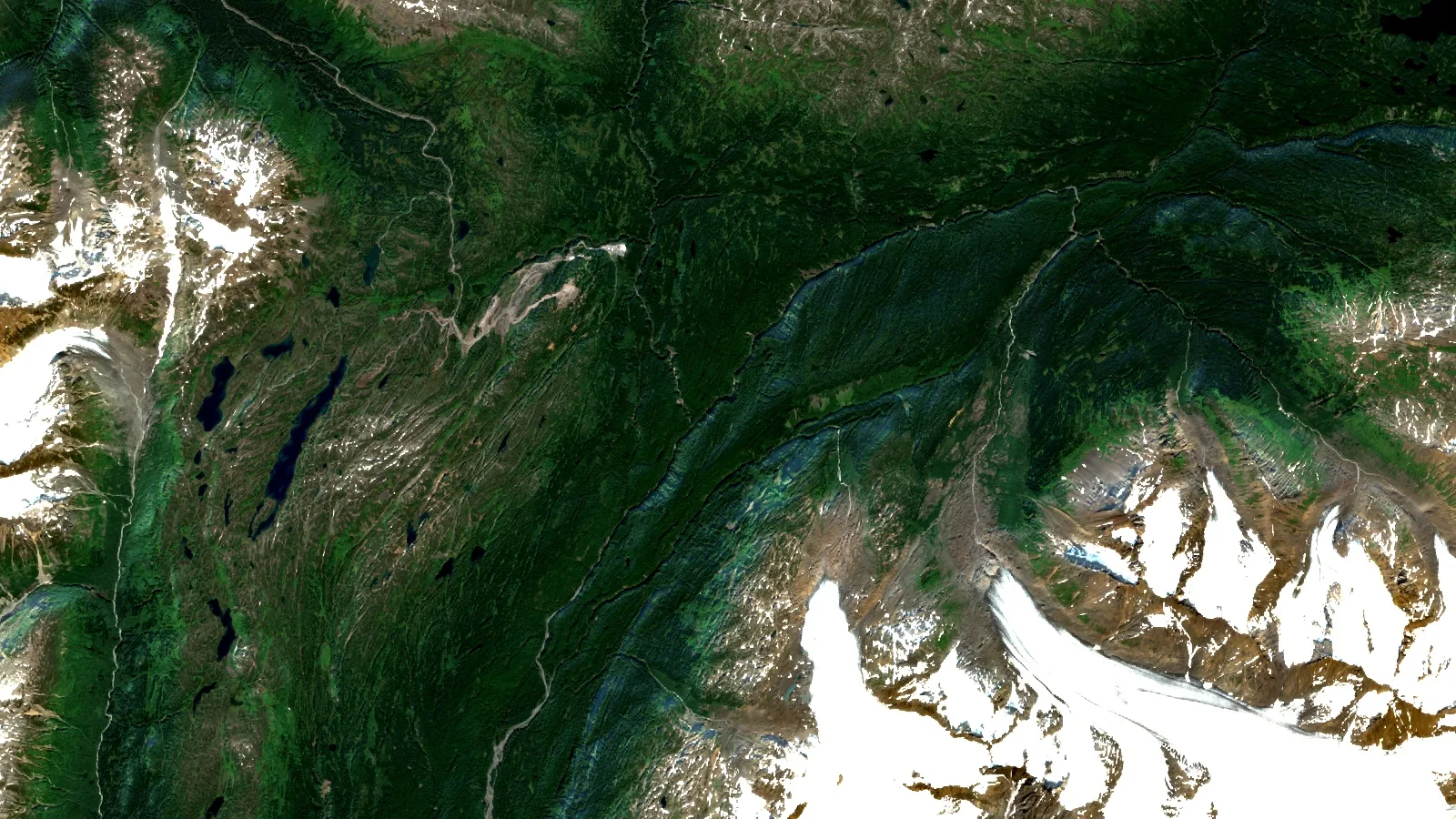
The Golden Triangle BC is the loosely defined mountain district of northwest British Columbia, around Stewart, Iskut and the lower Stikine, that holds most of the province’s major gold, silver and copper deposits and drew C$436.1 million, or 58% of BC exploration spending, in 2025.
Key takeaways
- The Golden Triangle BC sits in Stikinia, an old island-arc terrane; most deposits are tied to Early Jurassic Hazelton Group rocks and the intrusions that fed them.
- Porphyry copper-gold giants (KSM, Red Chris, Galore Creek) share the district with high-grade epithermal gold (Brucejack) and VMS-style gold-silver (Eskay Creek).
- The Northwest Region took C$436.1 million of exploration in 2025, 58% of the BC total, but only 7.4% of it was grassroots work.
- Snow and ice cover drops below a quarter of the area only in July, August and September (Farmonaut MODIS analysis, 2016 to 2025).
- Satellites help most before that window, mapping exposed alteration, structure, newly ice-free ground and access so helicopter hours go to the best targets.
In this article
- Where the Golden Triangle BC is, and why the deposits cluster there
- Golden Triangle BC deposit types: porphyry, epithermal and VMS
- Exploration spending and drilling in the Golden Triangle BC
- Glacier retreat in the Golden Triangle: new ground, new hazards
- Short field seasons and helicopter access in the Golden Triangle BC
- Satellite screening for Golden Triangle BC exploration in mountainous terrain
- Claims, permits and First Nations in the Golden Triangle BC
- Frequently asked questions about the Golden Triangle BC
Ask a BC geologist where the money goes and the answer is the Golden Triangle BC, a district of icefields, steep valleys and very large copper-gold systems along the Alaska border. This guide is for the people who hold claims, run programs or fund juniors there. It covers the deposit styles and what they look like at surface, the 2025 spending and drilling figures, how glacier retreat is opening ground, why the season is so short and so helicopter-dependent, and what satellite screening can and cannot do in mountainous terrain before a crew is mobilised.
For the mines that pour gold in the province today and the claim fee schedule line by line, read our guide to gold mining in BC, from Brucejack to your first cell claim. For how BC compares with Ontario, Quebec and the territories, see the overview of gold exploration in Canada. This page stays in the Golden Triangle BC and looks at it the way an exploration manager does: geology, money, ice, season and access.
More than 150 mines have operated in the Golden Triangle since prospectors arrived at the end of the nineteenth century.
Where the Golden Triangle BC is, and why the deposits cluster there
There is no legal boundary. The British Columbia Geological Survey describes the Golden Triangle as the popular name for a loosely defined region that includes most of the major gold, silver and copper deposits in west-central Stikinia. Stikinia, or the Stikine terrane, is a long-lived oceanic arc that runs for about 1,000 km along the Canadian Cordillera. In practice, people in the industry mean the mountains between Stewart in the south, the Iskut and Stikine rivers to the north and west, and Highway 37 to the east. Some searchers call it the golden triangle Canada district; locals simply say “the Triangle”.
The same circular says most Golden Triangle BC deposits are related to the Hazelton Group and its affiliated intrusions. The Hazelton Group is a pile of latest Triassic to Middle Jurassic volcanic and sedimentary rock that records the last stage of island-arc magmatism in Stikinia. The circular counts more than 150 mines that have operated since the end of the nineteenth century, with past producers such as Granduc, Eskay Creek, Anyox, Kitsault, Premier, Dolly Varden and Snip.
Why do so many deposits sit on so few lines? A 2014 BC Geological Survey field paper by JoAnne Nelson and Jeff Kyba traced a narrow, NNW-trending belt of mineralisation along a 60 km strike length from near Stewart north to the Treaty Glacier. Kerr-Sulphurets-Mitchell (KSM), Brucejack, Silbak-Premier, Big Missouri, Scottie Gold and Red Mountain all sit on it. All are hosted by Lower Jurassic Hazelton Group rocks and their subvolcanic feeders, including the 193 to 195 million-year-old Premier porphyries near Stewart. The authors argued that faults active at the time controlled where magma and hot fluids rose.
For a land manager, that is the most useful fact on this page. Ground in the Golden Triangle BC is not equally prospective. The contact between Triassic Stuhini Group rocks and the overlying Hazelton Group, and the faults that cut it, carry a large share of the known deposits. Mapping those contacts and faults is where both field crews and satellite interpretation earn their keep.

▶ Video (3 min 11 s): how satellite, soil and geochemical data are combined to look for copper and gold in British Columbia. · 3:11
Golden Triangle BC deposit types: porphyry, epithermal and VMS
The Nelson and Kyba paper describes mineralisation along the trend as diverse, even within individual deposits: porphyries, gold stockworks, shear-hosted veins, hydrothermal breccias and replacements. For planning, it helps to sort Golden Triangle BC targets into four families. Each one looks different at surface, needs a different budget and calls for a different first test.
| Deposit style | Golden Triangle examples | Owner and status (as published) | Surface footprint | What satellites can pick up |
|---|---|---|---|---|
| Porphyry copper-gold | KSM, Red Chris, Galore Creek, Iskut (Snip North) | KSM: Seabridge Gold, proposed mine. Red Chris: Newmont 70%, Imperial Metals 30%, operating. Galore Creek: Teck and Newmont 50:50, proposed. | Kilometre-scale alteration zones, iron staining, gossans | Iron oxide and clay/sericite patterns where rock is bare; structure |
| Epithermal gold-silver | Brucejack, Premier | Brucejack: Newmont, operating. Premier: Ascot Resources, mine development. | Narrow veins and stockworks, often within larger alteration | Host alteration and structure; veins are usually too small to resolve |
| VMS and precious-metal veins | Eskay Creek, Dolly Varden (Kitsault Valley) | Eskay Creek: Skeena, in construction. | Stratabound lenses in rift volcanic and sedimentary rocks | Stratigraphy and fault blocks; little direct signal |
| Intrusion-related gold veins | Snip, Scottie Gold | Exploration projects (BCGS listings) | Quartz-sulphide veins near intrusions | Intrusive contacts, lineaments, access |
Owners and status from the BC Geological Survey’s 2025 overview (Paper 2026-02, Tables 2, 5 and 7), Seabridge’s Q2 2026 MD&A and Skeena’s March 2026 update. Status changes often; check the company’s latest filing on SEDAR+.
Porphyry copper-gold: the giants of the Golden Triangle BC
Porphyry deposits are huge, low-grade bodies that form around a cooling intrusion. Our explainer on copper porphyry deposits, their alteration zones and grades covers the general model. In the Golden Triangle, KSM is the extreme case. Seabridge’s MD&A for the quarter to 30 June 2026 reports Proven and Probable reserves of 2,292 million tonnes grading 0.64 g/t gold and 0.14% copper, containing 47.3 million ounces of gold, based on its 2022 pre-feasibility study. The same filing says a feasibility study is targeted for the second half of 2027.
KSM’s permitting shows how much the social licence matters here. In June 2026 the Supreme Court of British Columbia found that the Environmental Assessment Office had not met its duty to consult the Tsetsaut Skii km Lax Ha on the project’s “substantially started” designation, and ordered a 90-day consultation followed by a reconsideration. Seabridge expected that decision in the fourth quarter of 2026. Until then, treat the project’s status as open.
Red Chris is an operating example. The BC Geological Survey’s 2025 overview lists it as a hybrid calc-alkalic to alkalic porphyry operated by Newmont (70%) with Imperial Metals (30%), with block-cave planning under way. Galore Creek, held by Galore Creek Mining Corporation (Teck and Newmont at 50% each), was completing a pre-feasibility study. For investors, the pattern is clear: the largest copper-gold tonnage in the Golden Triangle BC sits in a handful of projects controlled by majors, and juniors work the ground around them.
How much metal does a porphyry block hold? Grade numbers like 0.30% copper and 0.40 g/t gold look small. The calculator below turns tonnage and grade into contained metal and shows how much of the value comes from gold. In many Golden Triangle BC porphyries, gold is a large part of the story, which is why companies here call themselves copper-gold explorers.
Calculator
How much copper and gold is in a porphyry block?
Enter tonnage, grades and example prices. Values in US dollars (US$).
- Contained gold: 1,286,029 oz
- Copper in the ground (US$): $4,431,286,200
- Gold in the ground (US$): $5,343,450,094
- Gold share of metal value: 54.7%
- Copper-equivalent grade, no recoveries: 0.66 % CuEq
US dollars (US$). 1 tonne = 2,204.62 lb; 1 troy ounce = 31.1035 g. Default prices are Kitco quotes of 15 October 2026 (gold US$4,155/oz bid, copper US$6.70/lb), entered as examples only; check today’s price. The defaults describe an imaginary block, not any deposit. Results are metal in the ground before dilution, recovery, smelter terms, costs and royalties, so they are not a resource, a reserve or a valuation. General information, not investment advice.
At the defaults, an imaginary 100-million-tonne block at 0.30% copper and 0.40 g/t gold holds about 661 million pounds of copper and 1.29 million ounces of gold. At the 15 October 2026 Kitco prices, gold supplies about 55% of the metal value, and the block grades about 0.66% copper-equivalent before any recovery is applied. Change the gold grade to 0.20 g/t and the gold share falls to about 38%. That sensitivity is why gold grade, not just copper grade, drives so much Golden Triangle BC drilling.
Epithermal gold and the Brucejack model
Epithermal deposits form near surface from hot fluids and can carry very high grades in narrow zones. The BC Geological Survey describes Brucejack as an epithermal gold-silver deposit; its 2024 overview notes the underground mine is reached by a 75 km all-season road off Highway 37, the last 12 km of which crosses the Knipple glacier. That single detail tells you a lot about operating in the Golden Triangle BC. Ice is not just scenery; it is part of the road.
For explorers, the lesson of Brucejack is scale. A high-grade epithermal system can sit inside a much larger porphyry-style alteration footprint, and the high-grade part can be small. The satellite signal is in the alteration and the structure. The gold itself is found with drilling.
VMS-style gold and silver at Eskay Creek
Eskay Creek is a past producer listed by the BC Geological Survey as a VMS and precious-metal vein deposit. Skeena reported in March 2026 that construction was 49% complete at 28 February 2026, with initial production targeted for the second quarter of 2027. The survey’s 2025 overview notes the Tahltan Nation voted to support an Impact Benefit Agreement for the mine’s development and operation. VMS targets follow specific rift-related volcanic and sedimentary layers, so stratigraphy and fault blocks matter more than broad alteration.

▶ Video (2 min 47 s): how geophysics, hyperspectral imagery and lidar are combined to rank high-grade zones on a BC gold property. · 2:47
Exploration spending and drilling in the Golden Triangle BC
How much money flows into the district? The BC Mineral and Coal Exploration Survey, run by the Province, the Association for Mineral Exploration and EY, puts the province’s 2025 exploration spending at a record C$750.9 million, up C$198.8 million from 2024. The BC Geological Survey’s 2025 overview says the Northwest Region, home to the Golden Triangle, saw the most intense activity: C$436.1 million in spending and 456,925 m of drilling. That is about 58% of the money and about 49% of the 933,640 m drilled in the province.
The Northwest Region is bigger than the Golden Triangle BC. It covers about 263,000 km², roughly a quarter of the province, and also takes in Atlin, Turnagain and the Toodoggone edge. The regional geologist’s 2024 report says, though, that exploration is concentrated in the loosely defined northern area popularly known as the Golden Triangle. Read the regional figures as a ceiling for district spending, not an exact count.
Chart
Exploration spending by BC region
C$ millions, 2024 versus 2025, metal, industrial mineral and coal exploration
The year-on-year jump matters for juniors raising money. In 2024 the province’s total was C$552.1 million and the Northwest’s C$347.6 million, with the regional geologist noting that grassroots and early-stage projects run by juniors had found financing harder than in recent years. In 2025 every region except the Southeast grew. The overview names larger miners that increased investment in BC exploration and advanced projects in 2025, including Freeport-McMoRan, South32, Boliden, African Rainbow Minerals, Teck (Anglo Teck), Centerra Gold and Sumitomo Metal Mining.
Where Golden Triangle BC money goes, by stage
The headline number hides a split. The survey divides spending into five stages: grassroots, early stage, advanced, mine evaluation and mine lease. For the Northwest Region in 2025, the overview’s regional chart shows grassroots work at 7.4% of spending, early-stage at 19.6%, advanced at 25.1%, mine evaluation at 39.5% and mine lease at 8.4%. Applied to C$436.1 million, that is roughly C$32 million of grassroots work and about C$85 million of early-stage work, by our arithmetic.
Chart
Where Northwest Region exploration money went
Share of 2025 Northwest Region exploration spending by stage (%)
Province-wide, the overview puts grassroots and early-stage work at 26.8% of 2025 spending, down from 32.1% in 2024. New claim staking also fell. The survey recorded 1,254,146 ha of new mineral claims in 2025, down from 2,099,774 ha in 2024. Of the 2025 total, 641,340 ha were recorded between 1 January and 25 March, before the new consultation framework took effect, and 612,806 ha in the rest of the year.
Put those numbers together and a picture of the Golden Triangle BC emerges. Large, advanced copper-gold projects absorb most of the money and most of the metres. Grassroots ground acquisition slowed in 2025 as the claim process changed. That leaves room for juniors who can rank ground cheaply before committing to staking, permits and helicopter time.

▶ Documentary (11 min 35 s): satellite screening on glaciated northern ground across the border from the Golden Triangle, in southeast and interior Alaska. · 11:35
Glacier retreat in the Golden Triangle: new ground, new hazards
Ice is part of why the district stayed under-explored for so long, and part of why it keeps producing new showings. A Landsat-based inventory by Tobias Bolch, Brian Menounos and Roger Wheate, published in Remote Sensing of Environment, found that British Columbia’s glaciers lost 10.8% of their area between 1985 and 2005, give or take 3.8%. Across the whole inventory, glacier cover fell from 30,063 km² to 26,728 km².
The northern Coast Mountains, which take in the icefields along the Alaska border where much of the Golden Triangle BC sits, shrank least in percentage terms, by 7.7%. Because so much ice is there, that was still the largest loss in area: about 834 km², five times the loss in the northern Interior Ranges. Most of that newly bare rock and moraine has never had a geologist walk over it.
Chart
Glacier area lost in western Canada
Per cent of glacier area lost, 1985 to 2005, by region (Landsat inventory)
What does that mean in the field? Rock exposed in the last few decades has had little time to weather, so iron staining and alteration can be fresh and easy to see. Float (loose mineralised boulders) washed out of a retreating glacier can point up-ice to a source. Several explorers in the district have reported showings found at or near ice margins. Because those reports are company announcements rather than survey findings, we do not repeat their numbers here.
Retreating ice also brings hazards. Fresh moraine is loose. Slopes that the ice once buttressed can fail. Meltwater channels change from year to year. Any plan that targets newly exposed ground needs a mountain-safety plan, experienced pilots and a rule that no one samples under an unstable face.
Satellite archives are the cheapest way to see how much of a claim block has come out from under the ice. Comparing late-summer Landsat scenes from the 1980s with recent Sentinel-2 scenes outlines the newly exposed area, and the spectral bands show whether any of it carries iron-oxide or clay alteration. That turns “the ice has gone back” into a short list of places to land.

▶ Documentary (10 min 44 s): why exploration money is moving toward remote, harder-to-reach gold and copper-gold districts. · 10:44
Short field seasons and helicopter access in the Golden Triangle BC
How short is the season? We measured it. Using the MODIS MOD10A1 daily snow-cover product from the US National Snow and Ice Data Center, we averaged the share of a 0.9° by 1.2° box around the Stewart, Brucejack, KSM and Eskay Creek corridor that was snow or ice covered in each month from 2016 to 2025. In February, 92% of the area was white on a typical clear day. In August, the figure dropped to 19%.
Chart
When the Golden Triangle sheds its snow
Average share of the study area that is snow or ice covered, by month, 2016 to 2025 (%)
The curve is the field season. Snow and ice cover is still 46% in June and climbs back to 50% in October, so useful surface mapping and sampling is squeezed into roughly July to September. Part of the year-round white is permanent glacier ice, which MODIS counts as snow; the rest is seasonal snow that hides outcrop. Seabridge’s filing reflects the same rhythm, noting that site activities ramped up significantly in the second quarter, consistent with seasonal conditions, and that power work at the Treaty Creek Terminal would be finished by the end of the field season.
Clouds are the other constraint. In the same box we counted Sentinel-2 image tiles from 2019 to 2025 with less than 20% cloud. August had the most, 78 of 336 tiles, and November the fewest, 36 of 326. Even in the best month, most tiles are cloudy, so a usable summer composite needs several years of images.
Access: roads, power and the port
Infrastructure has improved more than the weather. BC Hydro’s 344 km, 287 kV Northwest Transmission Line from near Terrace to a substation near Bob Quinn Lake came into service in 2014, with Red Chris named as the first mine to use it. Highway 37 runs north through the district, and Brucejack’s 75 km road branches off it. Seabridge describes KSM as fully activated across five camps in 2026, with concentrate planned to move by truck to the seaport at Stewart.
Off those corridors, most Golden Triangle BC ground is still reached by helicopter. The BC Geological Survey’s 2024 overview opens with a photograph of helicopters moving a drill between targets. Camps, fuel, core and crews all fly. That is why every planning decision in the district comes back to one question: which targets deserve the flying hours?
Infographic
A Golden Triangle season, from desk to drill
- 1Desk screenMapPlace, MINFILE, ARIS and satellite review in the snow months.
- 2Acquire groundRegister claims on Mineral Titles Online, with MCCF consultation.
- 3Permit the workHold a Mines Act permit before any mechanical disturbance.
- 4Field seasonMap and sample July to September, when snow cover is lowest.
- 5Geophysics and drillingTest the best-ranked targets while access lasts.
- 6Register workRegistered exploration work keeps the claims in good standing.
The steps are sequential for a reason. The British Columbia Mines Act, section 10, requires a permit from the chief permitting officer before any work starts in, on or about a mine, unless an exemption applies, and a “mine” there includes exploration that mechanically disturbs the ground. Under the Mineral Tenure Act Regulation, a claim is kept in good standing by registering exploration and development work each anniversary year, at C$5 per hectare for each of the first two years, rising to C$20 per hectare from the seventh. The regulation lists the “preparation and geological interpretation of air photo, satellite or other remotely sensed images” among the kinds of technical work that can count, as long as it supports other exploration activity. Confirm current rules with the Ministry of Mining and Critical Minerals.
Satellite screening for Golden Triangle BC exploration in mountainous terrain
What can a satellite actually see in a glaciated mountain range? More than in a forest, less than in a desert. The Golden Triangle BC has a lot of bare rock above treeline, which is good. It also has steep slopes, deep shadow, long-lying snow and frequent cloud, which are not.
The workhorse is Sentinel-2. The European Space Agency’s mission page describes 13 spectral bands, four at 10 m, six at 20 m and three at 60 m resolution, with a five-day revisit at the equator from the two-satellite constellation. Its shortwave-infrared bands separate iron oxides and clay or sericite alteration from fresh rock, which suits porphyry and epithermal targets. Landsat adds an archive back to the 1980s, which is what makes glacier-retreat comparisons possible.
ASTER, the instrument many porphyry studies were built on, comes with a caveat. NASA’s Earthdata service warns that ASTER’s shortwave-infrared detectors have not worked since April 2008, so any SWIR alteration map from ASTER uses older scenes. In the Golden Triangle BC, some of that older ground was still under ice, so it can miss exactly the newly exposed areas you care about.
Limits you should plan around
- ⚠ Snow and ice: they hide rock for most of the year. Only July to September composites show the most outcrop.
- ⚠ Shadow and slope: north-facing walls stay dark in satellite images, and steep slopes distort spectral signals. A digital elevation model is needed to correct for this.
- Pixel size: a 20 m shortwave pixel is far wider than an epithermal vein. Satellites map the alteration halo and the structure, not the vein.
- Vegetation and till: below treeline, forest and glacial till mask the bedrock signal. Use structure and drainage there, not spectra.
- Cloud: most summer scenes are partly cloudy, so composites need several seasons.
None of this replaces fieldwork. What it does is shrink the area a crew has to cover. In terrain where a day of flying can cost more than the satellite screen of a whole claim block, that shrinking is the point.
How Farmonaut screens Golden Triangle BC ground
Farmonaut’s satellite-based mineral detection analyses reflected multispectral and hyperspectral energy, where each mineral and alteration zone has its own spectral signature, and runs it through proprietary algorithms to flag mineralised target zones, alteration halos, faults and fractures. You send the area of interest as coordinates, a KML or KMZ file or a polygon, with the target minerals; we choose the data source, run the analysis and deliver in 5 to 20 business days depending on size and mineral complexity. Copper and gold are both on our list of detectable materials, alongside silver, zinc, cobalt and nickel.
The premium mineral-intelligence report gives high-potential zones, prospectivity heatmaps, estimated location and depth ranges, an indicative quantity and a geological interpretation of faults, alteration and host rock, as a PDF plus georeferenced GIS files. The Premium+ report adds TargetMax drilling intelligence with drilling-angle recommendations and interactive 3D subsurface models of vein structures and mineral distribution. We have scanned more than 100,000 hectares across more than 25 countries and 20+ mineral types, and our approach can cut early-exploration timelines from months to days and early-exploration cost by up to 80 to 85%.
Satellite work fits alongside airborne surveys rather than replacing them. Helicopter magnetics and electromagnetics see below the surface, which spectral imagery cannot. Our guide to airborne geophysical survey platforms and specifications explains which survey suits which target. A practical order for a new Golden Triangle BC block is satellite screen first, airborne geophysics over the ranked areas second, then ground mapping and sampling in the summer window.
Claims, permits and First Nations in the Golden Triangle BC
Mineral claims in British Columbia are acquired online through Mineral Titles Online. Since 25 March 2025, claim registration has gone through the Mineral Claims Consultation Framework. The BC Geological Survey’s 2025 overview explains why: a 2023 BC Supreme Court ruling found that claim-related interests and exploration could affect First Nations rights and title, and that consultation must take place before a claim is registered. The Province says reform of the Mineral Tenure Act is under way with First Nations, so expect further change. The full fee and work schedule, with a holding-cost calculator, is in our BC gold mining and claims guide; for other jurisdictions see the mining cadastre portal guide by country.
Most of the district lies in Tahltan territory. The Tahltan Central Government says Tahltan Territory covers 95,933 km², about 11% of British Columbia, with its north-western border running parallel to the Alaska border and main communities at Telegraph Creek, Dease Lake and Iskut. Other Nations hold rights in parts of the district too: the KSM court ruling concerned the Tsetsaut Skii km Lax Ha. Engagement with the right Nations is part of the work plan, not a step after it.

▶ Video (10 min 34 s): what happens after discovery, from ore extraction to processing, for readers new to mine development. · 10:34
Data to start with is free. The BC Geological Survey’s MapPlace service lets anyone query geology, mineral titles and assessment reports together. MINFILE documents about 16,200 metallic mineral, industrial mineral and coal occurrences, and ARIS holds more than 41,500 assessment reports. In the Golden Triangle BC, many of those reports describe ground that was under snow or ice when it was mapped, which is one more reason to check them against current imagery. Our guide to the BC Geological Survey and other agencies’ free geology data walks through each database.
Finally, keep the economics in view. A district where 39.5% of regional spending goes to mine evaluation is one where the large projects set the pace. A junior’s edge is speed and focus: knowing, before the snow melts, which corner of its claims deserves the first helicopter landing.
Frequently asked questions about the Golden Triangle BC
Where is the Golden Triangle in BC?
In northwest British Columbia, roughly between Stewart in the south, the Iskut and Stikine rivers to the north and west, and Highway 37 to the east, along the Alaska border. The BC Geological Survey calls it a loosely defined region of west-central Stikinia, so there is no official boundary.
Why is it called the Golden Triangle?
Because it holds most of the major gold, silver and copper deposits in west-central Stikinia, and more than 150 mines have operated there since the late 1800s. The name is popular, not legal.
What types of deposits are found in the Golden Triangle BC?
Porphyry copper-gold (KSM, Red Chris, Galore Creek), epithermal gold-silver (Brucejack, Premier), vein and stockwork gold-silver (Red Mountain), VMS and precious-metal veins (Eskay Creek) and intrusion-related gold veins (Snip, Scottie Gold). Most are tied to Hazelton Group rocks and intrusions.
How much is spent on exploration in the Golden Triangle?
The Northwest Region, which contains the Golden Triangle BC, recorded C$436.1 million of exploration spending and 456,925 m of drilling in 2025, out of C$750.9 million province-wide (BC Geological Survey Paper 2026-02). The district itself is a large part of that regional figure.
When is the field season in the Golden Triangle?
Roughly July to September. Our analysis of 2016 to 2025 MODIS snow cover shows the area drops below a quarter snow or ice covered only in those months, with June at 46% and October at 50%.
Is glacier retreat exposing new mineral showings?
It is exposing new rock. BC glaciers lost 10.8% of their area from 1985 to 2005, and the northern Coast Mountains lost about 834 km². Explorers have reported showings near ice margins, but each needs to be checked in the company’s own filings.
How do you get to Golden Triangle BC projects?
Highway 37 and a few mine roads, such as Brucejack’s 75 km road, reach part of the district, and the Northwest Transmission Line brings grid power to Bob Quinn Lake. Most exploration ground is still reached by helicopter from camps.
How do I stake a claim in the Golden Triangle BC?
Through Mineral Titles Online, with a Free Miner Certificate. Since 25 March 2025, registration goes through the Mineral Claims Consultation Framework so affected First Nations are consulted first. Confirm current rules with the Ministry of Mining and Critical Minerals.
Can satellites find gold in the Golden Triangle?
Not directly. They map exposed alteration, iron oxides, structure, newly ice-free ground and access, which point to where gold and copper systems may be. Drilling confirms what is there. Satellite results are exploration targets, not resources.
Does satellite interpretation count as assessment work in BC?
The Mineral Tenure Act Regulation lists the preparation and geological interpretation of satellite and other remotely sensed images as technical exploration work, when it supports other listed activities. Confirm eligibility for your program with the Chief Gold Commissioner’s office.
Who owns the big projects in the Golden Triangle?
As published in 2025 and 2026: Newmont operates Brucejack and Red Chris (70%, with Imperial Metals 30%); Seabridge Gold holds KSM; Skeena is building Eskay Creek; Teck and Newmont each hold 50% of Galore Creek. Check SEDAR+ for current status.
General information, not legal, tax or investment advice. Claim rules change; confirm with the BC Ministry of Mining and Critical Minerals. Project owners and status change often; check company filings. Farmonaut results are exploration targets ahead of any resource estimate.
Farmonaut mineral detection
Map your Golden Triangle claims from space
Send your claim boundary as KML, KMZ or a polygon. Farmonaut returns ranked satellite exploration targets for it, usually in 5 to 20 business days.

Keep reading
Sources
- BC Geological Survey, The Golden Triangle of northwestern British Columbia, IC 2023-05 (2023): cmscontent.nrs.gov.bc.ca
- BC Geological Survey, Mining and Exploration in British Columbia, 2025, Paper 2026-02 (2026): cmscontent.nrs.gov.bc.ca
- BC Geological Survey, Provincial Overview of Exploration and Mining in BC, 2024, IC 2025-01 (2025): cmscontent.nrs.gov.bc.ca
- Nelson and Kyba, Treaty Glacier-KSM-Brucejack-Stewart trend, BCGS Paper 2014-1 (2014): cmscontent.nrs.gov.bc.ca
- Bolch, Menounos and Wheate, Landsat-based inventory of glaciers in western Canada, 1985-2005, Remote Sensing of Environment (2010): user.geo.uzh.ch
- Province of British Columbia, Mineral Tenure Act Regulation, B.C. Reg. 529/2004 (current 2026): bclaws.gov.bc.ca
- Province of British Columbia, Mines Act, RSBC 1996, c. 293 (current 2026): bclaws.gov.bc.ca
- Government of British Columbia, Mineral Titles Online (2026): mtonline.gov.bc.ca
- Government of British Columbia, Mineral Tenure Act reform engagement (2026): engage.gov.bc.ca
- Tahltan Central Government, Our Territory (2026): tahltan.org
- Seabridge Gold, MD&A for the period ended 30 June 2026, SEC Form 6-K (2026): sec.gov
- Skeena Resources, Eskay Creek project update, SEC exhibit 99.1 (March 2026): sec.gov
- BC Hydro, Northwest Transmission Line electrified (2014): bchydro.com
- European Space Agency, Sentinel-2 mission, SentiWiki (2026): sentiwiki.copernicus.eu
- NASA Earthdata, ASTER SWIR anomaly advisory (updated 2025): earthdata.nasa.gov
- NSIDC, MODIS/Terra Snow Cover Daily L3 Global 500 m, Version 61 (MOD10A1): nsidc.org
- BC Geological Survey, Online databases: MapPlace, MINFILE, ARIS, IC 2026-03 (2026): cmscontent.nrs.gov.bc.ca
- Kitco, gold price chart (15 October 2026): kitco.com
- Kitco, copper price (15 October 2026): kitco.com
Discussion
Questions, corrections or field experience? Share them below. First-time comments are reviewed before they appear, and your email is never published.
No comments yet. Be the first to add a question or your experience.

 Nanita Company Limited
 Mwerezi Minerals Company Limited
 Congo Mining Solutions
 Mining SARL
 SenGold Invest SAS
 Sania Corporation
 Sean Mining Limited
 NTS Group (Pty) Ltd
 Mine4Africa
 Lithspo Minerals Limited
 Tintina Mining Group
 Dalgety Minerals Pty Ltd
 Vortex Minerals Pty Ltd
 Faith At Work (Pty) Ltd
 Geotech Mining Solutions plc
 Vulcan International Limited
 Kidepo Associates
 GKY Mining
