

Gold depth · Geology guide
How Deep Is Gold Found? Depth by Deposit Type
Gold is mined from the surface down to about 3.7 km. Placer gold lies on bedrock, epithermal ore down to about 1.5 km below the water table, and the deepest mine, Mponeng, works 3,160 to 3,740 m down (Harmony Gold).
Key takeaways
- Placer gold collects at the base of gravel, on or just above bedrock (USGS Bulletin 1693).
- Epithermal gold forms down to about 1,500 m below the water table; ore zones are 100 to 800 m tall in the high-sulfidation type (USGS SIR 2010-5070-Q).
- Orogenic vein gold was deposited from 15 to 20 km deep up to the near-surface; erosion decides what you meet today (Groves and others, 1998, USGS record).
- Mponeng mines between 3,160 m and 3,740 m below surface; LaRonde works more than 3 km down (Harmony Gold; Agnico Eagle).
- Angled drill holes are longer than the depth they reach: about 1.15 times at 60 degrees, 1.41 times at 45 degrees.
In this article
- How deep is gold found in each type of deposit
- Placer gold: how deep to dig for gold in gravel
- Weathered and oxide ore: gold close to the surface
- Epithermal gold: shallow systems with a limited vertical range
- Orogenic veins and deep conglomerates: why gold reaches kilometres down
- Why gold sits at different depths today
- How deep are gold mines: open pit and underground
- How deep can a metal detector detect gold
- How explorers estimate the depth of gold before drilling
- Drill hole length, true depth and the cost of reaching a target
- What depth means for the decision to explore or buy
- Frequently asked questions
How deep is gold found? It depends on the type of deposit. Placer gold sits at the surface or just above bedrock, usually in the lowest layer of a gravel bed. Gold in weathered rock near the surface is mined from open pits. Gold veins and ancient gold-bearing conglomerates can run for hundreds of metres to several kilometres down: the deepest working gold mine, Mponeng in South Africa, is mined between about 3,160 m and 3,740 m below surface, as listed on Harmony’s page in November 2026 (Harmony Gold).
There is no single depth for gold, so this page gives a depth for each deposit type, the reason it sits there, and the way explorers estimate depth before they drill. It is written for licence and claim holders, consultants and investors who need to know whether the ground in front of them is a shovel job, an open pit or a drilling programme. One word needs care. “Depth” can mean the distance straight down from the surface, the length of a drill hole (longer if the hole is angled), or the depth at which a deposit formed millions of years ago. We use the first meaning unless we say otherwise.
How deep is gold found in each type of deposit
Geologists group gold deposits by the process that concentrated the metal. Each process works at a different depth, and erosion has since changed what is close to the surface. The table sets the main types side by side. Depth figures come from the sources named in each row; where a source gives a range, we quote the range and do not average it.
Chart
Reference mine depths for gold, in metres
Metres below surface, mine workings or shaft
| Deposit type | Where the gold sits | Depth guide | Source |
|---|---|---|---|
| Placer (river and stream gravel) | Loose gold in gravel, concentrated at the base on or near bedrock | At the surface down to the bedrock contact; gravel thickness varies by creek | USGS placer model |
| Weathered (oxide) cap over a hard-rock deposit | Gold released from sulfide by rain and air, near the top of the deposit | From surface to the base of weathering, then sulfide ore below | See the section below |
| Epithermal veins and breccias | Shallow hot-water systems linked to volcanic rocks | Formed within about 1,500 m below the water table; ore tops tens of metres to about 700 m below the water table in the high-sulfidation type | USGS SIR 2010-5070-Q |
| Orogenic (mountain-building) quartz veins | Gold-bearing quartz veins in folded, metamorphosed rock | Gold deposited from 15 to 20 km deep up to the near-surface; the depth you meet today depends on how much rock has eroded | Groves and others, via USGS |
| Ancient gold-bearing conglomerate (Witwatersrand) | Thin pebble beds buried under younger rock | Mined down to about 3.7 km at Mponeng | Harmony Gold |
| Deep rich ore bodies (LaRonde) | Gold-bearing ore lenses worked from deep shafts | LaRonde in Quebec is worked more than 3 km below surface | Agnico Eagle |
Two points follow from the table. First, the shallowest gold is not the poorest and the deepest is not the richest: depth tells you about how a deposit formed and how it must be mined, not about grade. Second, a deposit type tells you what to expect before you drill. If your licence covers a river valley, you are looking at gravel. If it covers a volcanic field with clay-altered rock, you are looking at a shallow system with limited vertical range. If it covers a shear zone in old metamorphic rock, the gold may continue far below anything you can see.
Placer gold: how deep to dig for gold in gravel
Placer gold is gold that erosion has released from its source rock and rivers have carried and dropped. Because gold is very dense, it sinks through the moving gravel and collects low in the bed. The US Geological Survey (USGS) descriptive model of placer gold says the highest values are at the base of gravel deposits, in traps such as natural riffles in the stream floor, cracked bedrock, and other structures that cross the direction of water flow, and that gold also collects above clay layers that stop it moving further down (USGS Bulletin 1693).
That gives a practical rule for anyone asking how deep to dig for gold in a creek. You do not dig to a fixed number of metres. You dig to the first hard surface: bedrock, or a clay layer that sits under the gravel. The gold is in the lowest part of the gravel and sometimes in the cracks of the top few centimetres of bedrock. Gravel above that layer is usually barren and has to be moved first. On a creek where the gravel is thin, that is a shovel job. Placers worked for gold range from terrace gravels to valley floors and are mined by panning, sluicing, hydraulic methods and dredging, with cut-off grades that depend on the method (USGS grade and tonnage model). Where the gravel is many metres thick, it needs machines, a drilling programme to find the bedrock, and a lot more money before a single flake is recovered.
Three cautions apply. Deep hand-dug holes collapse, so never work under an undercut bank or in an unsupported pit. Check that you have the right to dig: a claim gives rights to minerals, not always to the surface, and many streams need a permit. Never use mercury to catch gold; it poisons the water and the person using it. For more on veins that feed placers, see our guide to gold vein mining.
Weathered and oxide ore: gold close to the surface
Many hard-rock gold deposits start as sulfide ore: gold locked in or beside pyrite and other sulfide minerals. Near the surface, rain and air break the sulfide down. This weathering turns the top of the deposit into soft, rusty, oxidised rock, and can release some of the gold. The result is an oxide cap: a zone from the surface down to the base of weathering, with sulfide ore below it. How deep it goes depends on climate, rock type and how long the ground has been exposed. Its thickness varies from none to tens of metres.
The oxide cap matters because it is the cheapest gold to reach and often the cheapest to process. It can be mined by open pit and, in many cases, treated by simple methods, while the sulfide below usually needs a more costly route. Our guide to oxidized gold ore explains the signs and the processing difference. For a licence owner, this means the top few tens of metres can have a different grade, a different recovery and a different value from the rock beneath it. A drill hole that stops in the cap tells you little about the sulfide ore below.
Epithermal gold: shallow systems with a limited vertical range
Epithermal gold deposits form close to the surface of the Earth, in hot-spring and volcanic settings. The USGS model says they form at shallow depths, down to about 1,500 m below the water table at the time they formed, and that this shallow setting gives them a poor chance of being preserved: erosion removes them quickly in geological time (USGS SIR 2010-5070-Q). The same report lists how far down the ore starts and how tall the ore zone is for three subtypes. In the high-sulfidation type (gold with copper and arsenic minerals, linked to acid fluids), the top of the ore ranges from tens of metres to 700 m below the water table, and the ore zone is 100 to 800 m tall. In the low-sulfidation type (quartz-calcite veins from near-neutral fluids), ore tops start from a few metres to several hundred metres below the water table, and the zone is mostly 100 to 400 m tall. In the intermediate-sulfidation type, ore tops are several hundred metres below the water table and the zone can reach about 1,000 m.
Chart
Vertical height of epithermal ore zones
Metres, typical low and high end of the range
The vertical range tells an explorer where a vein is likely to stop. A low-sulfidation vein that shows at surface may carry gold for 100 to 400 m, then thin out. There may be a hundred-metre band in the middle where the best gold sits, with poorer rock above and below. Drilling that stops early or goes too deep can miss it. The chart shows the published ranges.
Orogenic veins and deep conglomerates: why gold reaches kilometres down
Orogenic gold deposits are quartz veins formed during mountain building, when hot fluids moved through folded and metamorphosed rock. Their depth range is unusually wide. A USGS record of the 1998 classification paper by Groves and colleagues says gold in these veins was deposited from 15 to 20 km deep up to the near-surface environment (USGS publication record). That is the depth at which the gold was laid down, not the depth at which you will meet it. Over millions of years the rock above has eroded, and a vein that formed at 10 km can now outcrop at the surface. A vein that formed at 3 km may still be buried. So the same type of deposit can be exposed in one country and deep underground in another.
Chart
Depth of formation vs deepest mine
Kilometres; formation depths are where gold was deposited, not where it is mined
Witwatersrand gold is a different case: not a vein but a set of thin, gold-bearing pebble beds laid down in an ancient basin. In the Witwatersrand, the gold-bearing beds lie deep, so the gold is reached through deep shafts. The reefs are thin: the Carbon Leader Reef is up to 1.2 m thick (University of Cape Town study). Mponeng, which mines the Ventersdorp Contact Reef, is listed by Harmony as working between 3,160 m and 3,740 m below surface, and a life extension project was approved in February 2024. Agnico Eagle’s LaRonde complex in Quebec uses a 2.2 km deep shaft, with operations extending more than 3 km below surface through an internal shaft (Agnico Eagle). Our separate guide to the deepest gold mines lists more of them; we do not repeat that list here.
Why gold sits at different depths today
Four things set where gold is now: the depth it formed at, how much rock has since eroded, how much younger rock has covered it, and how far weathering has changed the top. A shallow deposit in a stable, flat region can still lie at the surface. A deep deposit in a young mountain belt may have been lifted to the surface and worn flat. A deposit in an ancient basin may be buried under a kilometre or more of younger rock. That is why a geologist reading the surface tells you the rock type and structure but cannot read the depth of the gold directly.
It also explains why most of the gold people can reach is not the deepest gold. Gold goes deeper than any mine, but the cost of reaching it rises with every metre. Rock gets hotter, support gets harder and the ore has to be lifted further. Mines go deep only where the ore is rich enough and continuous enough to pay for it, which is why thin, high-grade Witwatersrand reefs and rich orebodies like LaRonde are worked at depth, while most deposits are mined from the surface down.

▶ How gold is formed: hot water, faults and quartz veins that explain why gold collects where it does. · 4:16
How deep are gold mines: open pit and underground
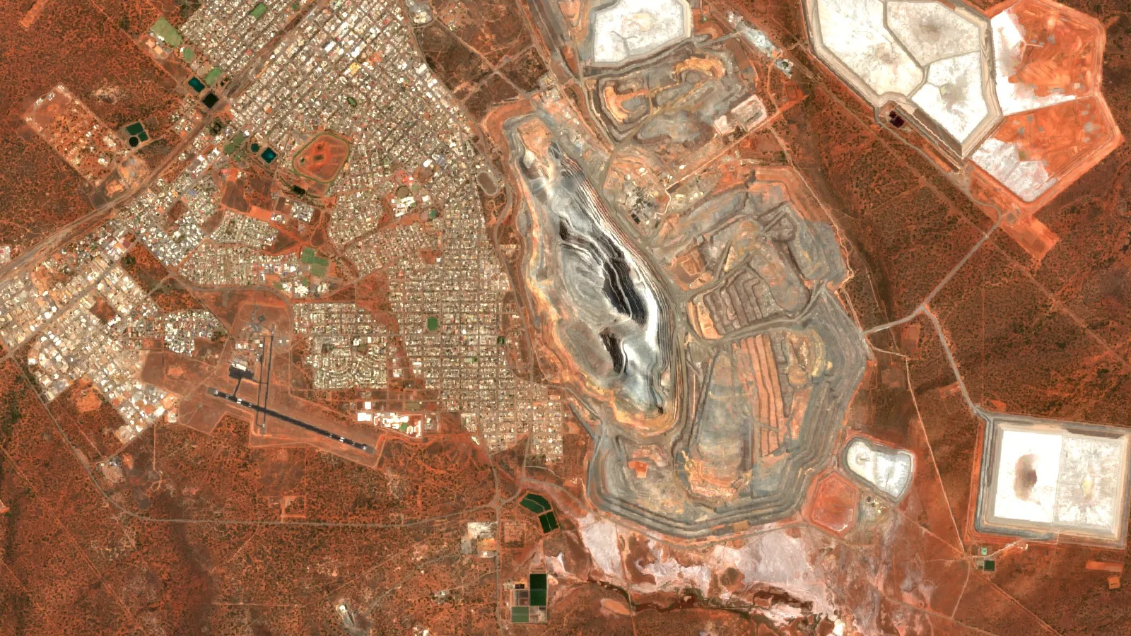
Open pits and underground mines both exist because depth changes cost. An open pit removes all the waste above and around the ore, so the waste per tonne of ore grows as the pit gets deeper. Eventually it costs more to remove the waste than the ore is worth, and the operator switches to underground mining or stops. Large open pits, such as the Super Pit at Kalgoorlie in Western Australia, are worked for years before the waste cost forces a change. Underground mines go deeper. Mponeng works at about 3.2 km to 3.7 km, and LaRonde’s operations extend past 3 km, but narrow reefs and steep veins are the usual targets because only a small amount of rock has to be removed for each tonne of ore.
The depth at which an operator switches from pit to underground is not fixed. It moves with the gold price, the cost of waste removal, the grade at depth and the slope of the pit walls. For a licence owner, the useful question is what mining method the ore body suits, as that sets the cut-off grade: the lowest grade that pays to mine. Deeper ore needs a higher cut-off, because each tonne costs more to get out. See our guide to types of gold deposits for how rock type and shape affect the choice.
▶ How gold is mined and refined, from the rock in the ground to the finished metal. · 5:27
How deep can a metal detector detect gold
A metal detector finds gold only a short distance below the coil, nowhere near the depths above. The signal weakens quickly with distance, so a small nugget is found only if it lies close to the coil, while a big mass of metal gives a signal from further away. Depth depends on the size of the target, the ground (mineral soil and salt are hard on a detector), the coil size and the settings. Makers usually describe the depth of a new model by comparison with the older one, not as an absolute number, so treat any “up to” claim as a best case in ideal conditions. The only reliable test is to bury a known target in your own ground and see where the detector loses it.
The key point for a claim holder is that a detector answers a different question. It finds loose metal near the surface. It does not tell you whether a deposit continues below your feet. For ground that may hold a lode, depth comes from geology, sampling and drilling.
How explorers estimate the depth of gold before drilling
Depth estimation is a stack of methods, each cheap early and more expensive later. The aim is to rank targets so drilling goes where it can answer a question.
- Surface geology and structure. A geologist maps the rock, the veins, and the dip (the angle at which a layer or vein tilts below the surface). With a measured dip, a vein seen at the surface can be projected downward on a cross-section.
- Deposit-type rules. Once the type is known, the published vertical ranges in the sections above give a first guess of how far the ore should go and where it should stop.
- Geochemistry. Soil and rock samples show where metal comes to the surface, and the pattern of pathfinder elements can show whether the top or the base of a system is exposed.
- Geophysics. Magnetic, gravity and electrical surveys see rock properties below the surface and can show structures and altered zones buried under cover.
- Satellite imagery. Satellites map surface and near-surface signatures: iron stain, clay and mica alteration, silica and fault lines. Farmonaut satellite mineral reports give signals to about 225 to 250 m depth, and sampling and drilling confirm what the images suggest (see how satellite mineral exploration works).
- Drilling. Drill holes are the only direct measure of depth. Core and chips show the rock, the grade and the depth at which gold starts and stops. Our guide to exploration drilling covers methods and planning.
A satellite screen is a ranking tool. It narrows a large licence to the parts most worth a geologist’s time, and results are exploration targets, not a resource, reserve or grade estimate under JORC, NI 43-101 or SAMREC rules. The depth signal it gives is a starting estimate that field work will refine or reject.

▶ What satellites can and cannot see: the rock around the gold, not the gold itself. · 4:25
Drill hole length, true depth and the cost of reaching a target
Drill holes are often angled to cut a steep vein across its width. An angled hole has to be longer than the vertical depth it reaches. If a hole is drilled at an angle of 60 degrees from horizontal, its length is about 1.15 times the vertical depth; at 45 degrees it is about 1.41 times. These factors come from simple geometry (one divided by the sine of the angle). Reports quote hole length, so a target “at 300 m” may mean 300 m of drilling or 300 m straight down. Always ask which one is meant.
The calculator below turns a target depth and a hole angle into total metres and cost. Use it to compare a shallow target with a deep one, or to check a driller’s quote. It does not include rig set-up, assays or casing beyond the figure you enter. Our guide to dry holes in mineral exploration explains why a well-placed hole can still miss, and what to do next.
Calculator
How long is the hole, and what will it cost?
Enter your own target depth, hole angle factor, number of holes and the driller’s rate.
- Length of one hole (m): 365
- Cost of one hole (US$): $36,500
- Total drilling cost (US$): $182,500
Example values only, not a benchmark. Length factor is 1 divided by the sine of the hole angle from horizontal: 90 degrees = 1.00, 60 degrees = 1.15, 45 degrees = 1.41. The cost per metre is an example, use your driller’s quote in US$ (all-in rate).
What depth means for the decision to explore or buy
For a buyer or investor, depth turns into three questions. How much rock sits above the gold? Can it be mined from the surface, or does it need a shaft? And does the oxide cap or the sulfide below carry most of the value? A deposit with a thick barren cover needs more drilling just to find the top of the ore, and more money before any gold is proved. A deposit at the surface is cheaper to test, but may be a thin cap that stops short.
Ask for these items before you commit: the depth to the top and the base of the mineralised zone in each drill hole, whether depths are vertical or down the hole, the dip of the structure, the depth of weathering, and what share of the contained metal lies in oxide rock and what share in sulfide. A report that gives a single “depth of gold” with none of these is not enough to decide on. Check any claim with the regional geological survey and, for rights and fees, with the ministry or land agency before you apply for ground.
Frequently asked questions
How deep is gold found in the ground?
From the surface to about 3.7 km in the deepest mine now working. Placer gold sits at the surface or on bedrock, epithermal gold formed within about 1.5 km below the water table, and the deepest working gold mine, Mponeng, is mined between about 3,160 m and 3,740 m (Harmony Gold).
How deep is gold underground in a vein?
Quartz veins can extend for hundreds of metres and, in orogenic systems, carry gold over a depth range that spans many kilometres in the crust. Shallow epithermal veins are shorter: the USGS lists ore zones of 100 to 800 m in the high-sulfidation type and mostly 100 to 400 m in the low-sulfidation type. Only drilling shows how far a given vein goes.
How deep do you have to dig to find gold?
In a creek, dig to bedrock or to the first clay layer under the gravel; the USGS places the richest gold at the base of the gravel. In hard rock, hand digging will not reach the ore for most deposits, so sampling and drilling are used. Get permission, never use mercury, and do not work in deep unsupported holes.
How deep are gold mines?
Open pits stop where waste removal costs more than the ore is worth. Underground, Mponeng reaches about 3.7 km and LaRonde’s operations extend past 3 km. Most mines are far shallower than these record holders.
How deep can a metal detector detect gold?
Only a short distance below the coil. The depth depends on target size, soil mineralisation, coil and settings, and makers give relative claims, not absolute depths. A detector cannot see a deposit at depth.
Does gold get richer with depth?
Not as a rule. In some deposits, the grade is higher below the weathered cap, and in others the oxide zone holds more gold than the rock below. Each deposit has its own pattern, which drilling shows.
Why is some gold at the surface and some kilometres down?
Because deposits formed at different depths, and erosion and cover have changed what is near the surface since. Orogenic gold was deposited from 15 to 20 km deep up to the near-surface (USGS record of Groves and others), so vein gold exposed today has been lifted up by erosion, while Witwatersrand gold is buried under younger rock.
Can satellites show how deep gold is?
Satellites map the surface and near-surface signatures that gold systems leave, such as alteration, iron stain and structure. Farmonaut reports give depth signals to about 225 to 250 m, but a satellite cannot see gold itself, and drilling is the way to confirm depth and grade.
How do geologists estimate the depth of a gold deposit before drilling?
They combine surface mapping and dip measurements, the typical vertical range of the deposit type, geochemical and geophysical surveys, and remote-sensing screening. The result is a set of drill targets and a first guess at depth, to be tested by holes.
Is deep gold worth mining?
Only if the ore is rich and continuous enough to pay for shafts, ventilation, cooling and hoisting. Deep mines such as Mponeng and LaRonde work thin or rich ore. Most deposits are mined from the surface because it costs less per tonne.
This page is for information only. It is not investment advice or legal advice. Confirm claim and licence rules with the regulator, get permission before you dig or prospect, and never use mercury.
Farmonaut mining
Screen your licence before you drill
Send a boundary and get a satellite screening report that maps alteration and structure as exploration targets in 5 to 20 business days.

Mining Pro sample view, synthetic data
Sources
- Harmony Gold, Mponeng operation page: harmony.co.za
- Agnico Eagle, LaRonde Complex operation page: agnicoeagle.com
- USGS, Descriptive Model of Placer Au-PGE (Bulletin 1693): pubs.usgs.gov
- USGS, Descriptive Models for Epithermal Gold-Silver Deposits (SIR 2010-5070-Q): pubs.usgs.gov
- USGS publication record: Groves and others, Orogenic gold deposits (Ore Geology Reviews, 1998): pubs.usgs.gov
- University of Cape Town, Carbon Leader Reef study (Grove and Harris): open.uct.ac.za
- USGS, Orogenic gold deposits classification (Groves and others, 1998), publication page: usgs.gov
- USGS, Grade and Tonnage Model of Placer Au-PGE (Bulletin 1693): pubs.usgs.gov
Discussion
Questions, corrections or field experience? Share them below. First-time comments are reviewed before they appear, and your email is never published.
No comments yet. Be the first to add a question or your experience.

 Energy and Resources Ltd
 Mwerezi Minerals Company Limited
 Congo Mining Solutions
 Mining SARL
 SenGold Invest SAS
 Sania Corporation
 Sean Mining Limited
 NTS Group (Pty) Ltd
 Mine4Africa
 Lithspo Minerals Limited
 Tintina Mining Group
 Dalgety Minerals Pty Ltd
 Vortex Minerals Pty Ltd
 Faith At Work (Pty) Ltd
 Geotech Mining Solutions plc
 Vulcan International Limited
 Kidepo Associates
 GKY Mining
 Alkimy SARL

 Licence holder · Nigeria · Gold + lithium
 Client · Somalia · Gold










