

Drones in Agriculture: 7 Ways They Boost Yields
Introduction: The Role of Drones in Modern Agriculture
Drones, known technically as unmanned aerial systems (UAS), have emerged as a transformative tool across agriculture, forestry, mining, and infrastructure management. Their integration into daily operations is revolutionizing how we approach farming, resource allocation, environmental monitoring, and sustainability planning.
In today’s fast-evolving world, the agricultural sector faces mounting pressure to increase yields while minimizing resource use and environmental impacts. Drones enable precise aerial mapping, real-time monitoring, advanced data collection, and even application of inputs (water, fertilizers, and pest control agents).
This blog explores seven key ways drones boost yields in agriculture, enriched by their expanding role in resource management across different sectors. We’ll delve into the practical benefits, key technologies, industry trends, and actionable insights for sustainable farming and ecosystem stewardship.



Why Drones? Exploring the Transformation of Agriculture
Drones provide an unmatched aerial perspective, unlocking a new paradigm for monitoring, management, and optimization in both traditional and digital agriculture. Their advanced sensors and imagery open the door to precise mapping, crop monitoring, early detection of plant stress, and data-driven planning, ultimately raising yield potential and resource efficiency.
- ✔ Aerial mapping covers expansive fields rapidly, supporting accurate inventory, stand counts, and yield forecasting.
- 📊 Multispectral and thermal imaging enable early detection of disease, nutrient deficiencies, or water stress.
- ⚠ Environmental impact tracking ensures regulatory compliance and supports sustainable resource use.
- ✔ Automated data processing delivers actionable insights for variable-rate application and input reduction.
- 📊 Integration with management systems streamlines decision-making, boosting operational efficiency.

Drones in Agriculture: 7 Ways They Boost Yields
Let’s explore the core focus of this blog—how drones are driving major advances in agriculture by optimizing resource management, crop health, and environmental sustainability through the following seven applications:
-
🌱 High-Precision Crop Monitoring & Mapping
Aerial multispectral, hyperspectral, and RGB imagery reveal crop vigor, stand count, leaf area, and more—supporting early detection of deficiencies and stress. -
🛑 Early Detection of Diseases, Pests, and Nutrient Problems
Advanced sensors (including thermal and hyperspectral cameras) detect outbreaks of stress, enabling rapid response and targeted treatment. -
💧 Smart Irrigation & Water Stress Management
Thermal data and evapotranspiration estimates help optimize irrigation scheduling, conserving water and improving yields. -
🚜 Variable-Rate Fertilizer and Agrochemical Application
Aerial data supports variable-rate application, reducing input waste, lowering costs, and minimizing environmental impacts. -
📈 Yield Forecasting & Crop Modeling
Drone-enabled spectral indices (like NDVI, EVI) link remote observations to yield potential for improved planning. -
🕹️ Automated Stand Assessments and Inventory Tracking
Drones track growth, inventory, and productivity across large and rugged areas, supporting forest and plantation resource management. -
🌳 Environmental Impact Monitoring & Regulatory Reporting
Drones collect vital environmental data—from carbon footprint measurements to sediment, water quality, and land use changes—for regulatory compliance and sustainability initiatives.
Combine drone imagery with ground-truthing and climate models for the most robust crop forecasts and resource allocation.

1. High-Precision Crop Monitoring & Mapping
Drone-based aerial imagery and mapping systems provide a bird’s-eye view for detailed and timely assessment of crops. These multispectral, hyperspectral, and RGB sensors can quickly scan vast areas, capturing plant health indices (such as NDVI and EVI), leaf chlorophyll, canopy structure, and stand uniformity.
- 📊 Rapid field coverage (hundreds of hectares per hour) for frequent updates.
- ✔ High spatial and temporal resolution for true precision farming.
- ⚠ Visualize “hidden” problems invisible to the human eye, such as water or nutrient stress.
- 📝 Data-driven management zones for targeted actions.

2. Early Detection of Disease, Pests, and Nutrient Deficiencies
Identifying disease outbreaks, pest pressure, or nutrient imbalances early is crucial for high-yield, low-input agriculture.
- ✔ Thermal and multispectral cameras detect hidden stress signals before they’re visible on the ground.
- 🛑 Automated detection algorithms using AI and spectral indices classify the type and severity of outbreaks for rapid response.
- ⚠ Reduces crop losses and limits unnecessary chemical application.
3. Smart Irrigation & Water Stress Management
One of the most resource-intensive aspects of farming is irrigation. Drones equipped with thermal cameras and sensors can detect moisture stress, pinpointing dry or overwatered areas. By quantifying evapotranspiration, these tools inform:
- 💧 Optimized irrigation scheduling for each field zone
- ✔ Water savings and reduced energy/pumping costs
- ⚠ Avoidance of root diseases and waterlogging by applying water only where needed
Relying solely on visual cues for water management. Thermal sensing from drones provides real-time, precise moisture status, guiding actionable irrigation decisions.
4. Variable-Rate Fertilizer and Agrochemical Application
With drone-enabled data from aerial surveys, farmers can apply fertilizers and pesticides in exact amounts, where and when needed.
- ✔ Input reduction: Avoids over-application, saving on costs and reducing environmental load.
- 🧑🔬 Tailored applications: Targeting only stressed or deficient field zones.
- ⚠ Decreases runoff and helps comply with environmental regulations.
- 🌱 Promotes sustainable resource management across the farm.

5. Yield Forecasting & Crop Modeling
Drones are instrumental in digital agriculture by providing high-frequency, high-resolution imagery to monitor crop development. By linking remote-sensing indices (NDVI, EVI, etc.) and weather models, advanced machine learning algorithms can predict yield quantity and quality.
- 📈 Enables forward planning for harvest, logistics, and supply chain.
- ✔ Supports decisions on input level adjustments and mitigation of risk (e.g., yield loss from weather).
- 📝 Data-driven reporting for contracts, crop loans, and insurance solutions.
Looking to streamline crop loan approvals and insurance processes?
Farmonaut’s Satellite-based Crop Loan and Insurance Verification
can help financial institutions and farmers with fast, accurate, and fraud-resistant verification for agriculture and mining.
6. Automated Stand Assessments and Inventory Tracking
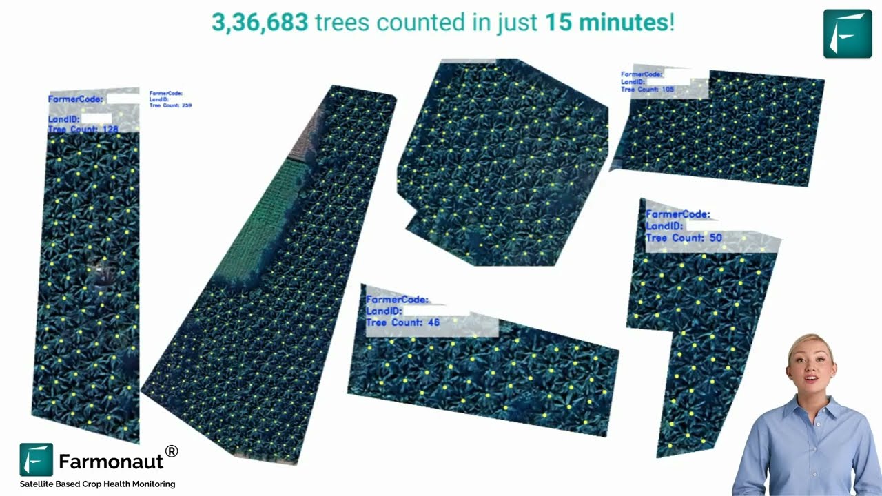
Integrating drone surveys with AI-driven image processing enables rapid, accurate inventory of crops, plantations, and even forestry assets. This extends to:
- ✔ Stand counting for replanted fields or reforestation project success tracking.
- 🌳 Bark beetle and disease monitoring in forestry stands.
- 📦 Automated inventory management for agriculture or timber planning.

7. Environmental Impact Monitoring & Regulatory Reporting
Drones are at the forefront of environmental stewardship. High-resolution aerial imagery enables regulatory monitoring of farm practices, assessment of carbon footprints, and even conservation efforts in sensitive ecosystem areas.
- ✔ Measuring CO2 sequestration for carbon credit initiatives.
- 💧 Detecting sediment runoff and water use patterns for compliance management.
- 🌱 Surveying biodiversity and land use for sustainable ecosystem and community relations.
Want to track and report environmental sustainability?
Explore Farmonaut’s Carbon Footprinting Solution
for agriculture and mining—enabling accurate, automated tracking of carbon emissions and sustainable practice implementation.
Comparative Impact Table: Drone Applications in Agriculture
| Drone Application | Estimated Yield Increase (%) | Input Reduction (%) | Coverage Speed (ha/hour) | Environmental Impact | Additional Benefits |
|---|---|---|---|---|---|
| Crop Monitoring & Mapping | 10–15% | 15–25% (fertilizer/pesticide) | 80–120 | Lower CO₂ from reduced machinery use | Improved plant stand counts, early stress signals |
| Disease & Pest Detection | 5–10% | 20–30% | 60–100 | Fewer chemical sprays (less run-off) | Targeted outbreak response |
| Smart Irrigation Management | 8–12% | 20–35% (water) | 60–90 | Water savings, reduced soil erosion | Prevents disease due to overwatering |
| Variable-Rate Input Application | 7–10% | 18–35% | 50–100 | Reduced leachate, environmental compliance | Lower input costs, less pollution |
| Yield Forecasting | 5–8% | N/A | 80–120 | Efficient resource allocation | Improved planning, decision support |
| Stand Assessment & Inventory | 4–7% | — | 150–200 | Resource conservation, digital records | Streamlined replanting, forest health |
| Environmental Monitoring | Indirect | N/A | 100–150 | Tracks CO₂, prevents soil/water loss | Regulatory compliance, carbon credits |
- ✔ Fast, frequent monitoring for better yield decisions
- 📊 Efficient use of water, fertilizer, and pesticides
- ⚠ Minimized environmental impact and improved regulatory compliance
- ✔ Automated, actionable insights for diverse crops and regions
- 🧩 Easy integration with modern farm management systems and APIs

Drones in Resource Management: Expanding Beyond Agriculture
The application of drones extends far beyond crop cultivation. In forestry, mining, exploration, and infrastructure management, drones deliver timely, accurate, and cost-effective aerial data that supports:
- Drones equipped with LiDAR provide unparalleled three-dimensional models of forest structure for biomass calculations and carbon accounting.
- Environmental monitoring is enhanced, enabling remote assessment of water bodies, sedimentation, and vegetation health near mining and industrial areas.
- Aerial surveys offer a safe, rapid alternative to traditional ground assessments in hazardous or large-scale locations.
Latest Drone Technologies in Precision Agriculture
Modern drone systems leverage cutting-edge advances in sensor technology, AI data processing, automation, and ecosystem integration:
- ✔ Hyperspectral, multispectral, and thermal cameras for detailed stress detection, plant health assessment, and nutrient mapping.
- 📊 Machine learning-driven analytics transform aerial maps into actionable prescriptions for input application and forecasting.
- 🧑🔬 LiDAR payloads quantify biomass, forest structure, and soil erosion—essential for both carbon accounting and regulatory compliance.
- 🛰️ Integration with satellite data and automated farm management systems for end-to-end decision support.
- ⚙️ Customizable APIs enable developers to automate workflows and connect drone data with farm management apps; check Farmonaut’s API platform or review the API Developer Docs here.
For large-scale resource management, combine drones with satellite-driven platforms like Farmonaut for maximum coverage, frequency, and cross-sector insights—no expensive on-farm hardware required.
Farmonaut: Satellite and AI-Driven Agricultural Solutions
At Farmonaut, we harness satellite imagery, AI analytics, and blockchain to deliver affordable, scalable solutions for agriculture, mining, infrastructure, and resource management globally. Our mission is to empower users—from individual farmers to large enterprises and governments—to unlock the power of data-driven decisions that drive productivity, sustainability, and transparency.
With our platform you can:
- ✔ Access real-time crop monitoring and predictive analytics for precision farming.
- 🛰️ Use AI-based advisory systems (like Jeevn AI) for tailored input recommendations, weather forecasting, and operational optimization.
- 🛡️ Leverage blockchain-based traceability to validate the authenticity and sustainability of agricultural or mining products.
- 🔄 Integrate with fleet management for logistics and maintenance planning.
- 📊 Monitor environmental impact—from carbon tracking to sediment run-off—helping users adopt strict compliance and regenerative strategies.
Meet sustainability and traceability goals with confidence.
Farmonaut’s Product Traceability solution leverages blockchain to securely record each stage of production and distribution, building consumer trust and reducing fraud across the supply chain.
Best Practices and Considerations for Drone Deployment
To maximize the value of drones in agriculture and resource management, carefully address the following considerations:
- ✔ Choose the right platform: Multirotor drones provide detailed inspection at low altitude; fixed-wing models cover extensive fields fast.
- 📊 Select appropriate sensors: Determine whether RGB, multispectral, thermal, or LiDAR payloads best serve your operational goals.
- ⚙️ Data calibration and georeferencing: Every flight’s data must be properly stitched and referenced for accuracy—leverage robust processing pipelines for best results.
- ⚖️ Integrate drone data with management tools: Use APIs and farm management platforms (like Farmonaut) to unify workflow and output formats.
- 🚦 Comply with regulations: Secure permissions, ensure pilot expertise, and implement geofencing, fail-safe, and privacy protocols (especially near community areas or neighboring properties).
Overlooking the need for robust data management and post-flight processing. Actionable insights require rigorous sensor calibration, georeferencing, and mosaicking workflows.
- 📝 Regulatory Compliance
Adhere to local aviation laws, secure necessary waivers, maintain flight logs, and respect neighbor privacy. - 🛡️ Safety Protocols
Implement geofencing, return-to-home, and emergency abort mechanisms for each operation. - 🤝 Data Governance
Establish policies on data sharing, ownership, and retention to build trust with stakeholders and communities.
Building your own integrated solutions? Farmonaut’s API allows seamless integration of satellite and drone data into your apps, dashboards, or custom analytics. See the API Developer Guide for quick starts or custom use cases!
FAQ: Drones in Agriculture and Resource Management
How do drones optimize crop yields?
Drones enable rapid and accurate aerial surveys of farmland, providing multispectral and thermal data that reveal crop health, stress, nutrient deficiencies, and pest or disease outbreaks. This allows for timely, targeted interventions and variable-rate application of water, fertilizer, and pesticides, thereby boosting yields while reducing input costs.
Can drones also be used in forestry and mining?
Yes! Drones are increasingly being deployed in forestry to map tree stands, detect beetle infestations, and monitor reforestation projects. In mining and mineral exploration, they deliver high-resolution aerial imagery, support pit and haul road design, and enable environmental impact monitoring.
What types of sensors are most useful for agriculture?
Multispectral cameras are widely used for plant health and stress detection. Thermal cameras provide water stress and irrigation insights. Advanced operations may deploy hyperspectral or LiDAR sensors for detailed resource modeling, structure mapping, and environmental impact detection.
Is it difficult to process drone data for farm management?
Processing drone data requires robust software for sensor calibration, georeferencing, stitching, and analytics. Integrated platforms, like those from Farmonaut, streamline this workflow—delivering ready-to-use insights through web, mobile, and API interfaces.
What are the main barriers to adopting drones in agriculture?
Barriers include initial capital investment, technical expertise, regulatory compliance, data management challenges, and the need to integrate drone outputs with existing management systems. Subscription-based solutions and service providers (like Farmonaut) can help accelerate adoption by offering turnkey, affordable solutions and technical support.
Underestimating the importance of ongoing data management—raw drone imagery alone does not create value. Action comes from integrating processed, actionable maps into everyday decisions, farm management software, and supply chain workflows.
Conclusion: Drones Power the Future of Sustainable Farming
The role of drones in modern agriculture and resource management is nothing short of transformative. From high-precision crop monitoring and variable-rate application to environmental impact tracking and landscape-level resource optimization, drones empower data-driven, sustainable operations at scale. Their benefits extend seamlessly into forestry, mining, exploration, and infrastructure, supporting the global transition toward efficient, climate-smart, and resilient ecosystems.
As advanced sensors, AI analytics, and ecosystem integration mature, drones will form the backbone of real-time decision-support systems—linking aerial data, satellite technology, ground truth, and supply chain information for the world’s food producers and resource managers.
At Farmonaut, we’re committed to democratizing access to these technologies—offering affordable, scalable solutions that foster productivity, transparency, and sustainability in agriculture and beyond.
Ready to experience the next generation of farming and resource management?
Explore our Crop Plantation and Forest Advisory services or download our app today.
Join us—let’s shape the future of sustainable agriculture, forestry, and resource management together with the intelligent use of drones and aerial data!
Discussion
Questions, corrections or field experience? Share them below. First-time comments are reviewed before they appear, and your email is never published.
No comments yet. Be the first to add a question or your experience.

 SFX
SFX BACF Africa
 Nivia
Nivia Doodlakine
 Exurbia Geospatial
 FieldZero
 Indico Company
 Kubota
 FFBS
FFBS Jontra
 Tucor
Tucor Hayleys Agriculture
 Licence holder · Niger · Gold
 Licence holder · Nigeria · Gold + lithium










