

Reviewed September 2026 against USDA Forest Service Research (Fish and Wildlife Research), the US Fish and Wildlife Service species database, and USDA Forest Service Landscape Change Monitoring System.
Try it: Run your own numbers →
Forest monitoring works because animals are the fastest-moving indicator a forest has — vegetation takes years to show stress, but bird populations, amphibian counts, and mammal activity shift within a single season. In the United States, forest monitoring programs currently track 1,684 threatened or endangered plant and animal species and count 214 species that have already gone extinct, according to the US Fish and Wildlife Service’s species listings database. That gap between “still here” and “gone” is exactly what forest monitoring software and systems are built to catch early.
This article covers what animals in a forest ecosystem actually do, how forest ecosystem animals are counted and tracked, what forest monitoring software exists and how it works, and how you can apply the same logic — satellite-based, repeatable, verifiable — to a forest or plantation you manage.
What Forest Monitoring Actually Measures
Forest monitoring is the repeated, dated measurement of a forest’s vegetation, water, and wildlife so that change — decline or recovery — can be detected against a known baseline. The USDA Forest Service’s Landscape Change Monitoring System (LCMS) has produced annual forest-change maps for the continental United States, Alaska, and Hawaii covering every year from 1985 to the present, refreshed with a new annual layer each fiscal year. That 40-year span is the reason LCMS is treated as a reference baseline rather than a one-off survey: a single year of data tells you almost nothing about a forest; four decades of consistent annual layers tells you whether a specific stand is recovering, declining, or stable.
Wildlife monitoring runs on the same logic but on a faster clock. The USDA Forest Service’s Southern Research Station tracks population trends for 59 forest bird species across multiple survey years; between 2017 and 2023, 32 of those species showed increasing population trends and 27 showed declining trends. That split — roughly 54% up, 46% down, among species monitored in the same forests over the same seven years — is a more useful headline number than any single “biodiversity is declining” statement, because it shows monitoring catching divergent trajectories inside one ecosystem type rather than a single direction for everything.
Farmonaut’s Large Scale Farm Management Platform applies this same before/after logic to cultivated and forested land under active management, using satellite vegetation indices instead of field survey crews for the frequency layer.
Animals in a Forest Ecosystem: The Functional Roles
Animals in a forest ecosystem are not passengers — they perform five measurable functions that vegetation-only monitoring misses entirely. Each is worth tracking separately because each fails independently.
- Regulating plant growth and regeneration: Herbivores such as deer and small mammals shape forest composition through selective browsing, which in turn determines which seedlings establish and which don’t.
- Maintaining trophic balance: Predators — raptors, foxes, wildcats — control herbivore populations, preventing the overgrazing that would otherwise suppress regeneration entirely.
- Supporting seed dispersal and pollination: Birds, bats, and small mammals move seeds and pollen across forest patches, which is the mechanism behind genetic diversity in naturally regenerating stands.
- Accelerating nutrient cycling: Invertebrates and scavengers break down organic matter and return nutrients to soil — the process underlying long-term soil fertility. Nutrient recycling operates on comparable principles wherever organic material breaks down and re-enters a system, including reclaimed land outside forest settings.
- Engineering habitat: Species like beavers alter hydrology directly, creating wetlands that support species the original forest structure could not.
Each function is independently detectable through monitoring: browsing pressure shows up as vegetation-index anomalies, predator activity shows up in camera-trap or survey counts, seed dispersal shows up as regeneration patterns years later, nutrient cycling shows up in soil and canopy-greenness data, and habitat engineering shows up directly in surface-water extent on satellite imagery.
Carbon footprinting for forests and agricultural landscapes ties directly into this: nutrient cycling and vegetation regeneration rates are inputs to carbon sequestration estimates, so animal-driven ecosystem function and carbon accounting are measuring overlapping processes.
Forest Ecosystem Animals: What the US Data Actually Shows
Ask “how many forest ecosystem animals are at risk in the US” and the honest answer starts with what is and isn’t published. The US Fish and Wildlife Service’s Environmental Conservation Online System (ECOS) publishes a running count of species listings by year: as of 2025, that count stood at 1,684 threatened or endangered plant and animal species nationally, and 214 species listed as extinct. These totals span all taxa and all ecosystem types, not forest species alone — the ECOS database does not publish a standalone “forest-only” subtotal, so a forest-specific figure has to be built by cross-referencing individual species’ listed habitat with forest cover, which the database supports on a species-by-species basis at the URL below.
One category where forest linkage is closer to direct: insects. As of October 2024, the US Fish and Wildlife Service listed 76 insect species in the US as in danger of extinction, a category heavily weighted toward pollinators and decomposers — both forest-dependent functional groups covered above.
| Metric | Count | As of |
|---|---|---|
| Threatened or endangered species, all taxa | 1,684 | 2025 |
| Extinct species (formerly listed or documented) | 214 | 2025 |
| Insect species in danger of extinction | 76 | October 2024 |
| Forest bird species monitored (USDA Forest Service) | 59 | 2017–2023 survey window |
The gap the research turned up matters as much as the numbers themselves: there is no published, citable baseline for the total number of animal species living in US forests specifically — only the threatened, endangered, and extinct subsets are tracked as standing counts. If you need a full-diversity baseline for a specific forest type or region, the method is to combine a regional species checklist (state wildlife agency or USDA Forest Service regional office) with the ECOS status lookup for each species, rather than relying on a single national figure, because none exists.
For a live, current number rather than this snapshot, the ECOS “Listed Species Count by Year” report updates continuously and is the authoritative source: US Fish and Wildlife Service species listings by year.
A Working Example: The Bosque Ecosystem Monitoring Program
The Bosque Ecosystem Monitoring Program (BEMP), established in the 1990s along New Mexico’s Middle Rio Grande, is a concrete example of long-term forest ecosystem monitoring in the field rather than a satellite-only exercise. It tracks animal, plant, water, and soil dynamics in cottonwood-willow riparian forest — locally called “bosque” — and remains one of the longest-running community-science forest monitoring efforts in the southwestern US.
What BEMP Tracks
- Wildlife surveys: Birds (including the endangered Southwestern willow flycatcher), mammals such as beavers, amphibians, and invertebrates, on annual and seasonal cycles.
- Vegetation assessments: Growth, regeneration, and native-versus-invasive composition.
- Hydrological and soil data: Groundwater recharge, water availability, and soil nutrient levels.
- Remote sensing: Drone and satellite layers for landscape-level change detection alongside the ground survey data.
- Community involvement: Students and local volunteers trained to collect field data, which is what makes the multi-decade cadence financially sustainable.

Regeneration and soil-health strategies used in these regenerative practices mirror the same nutrient-cycling logic BEMP tracks in riparian forest.
Key Animal Interactions Documented in Bosque Forest
Beavers are the clearest engineering example: dam-building slows water flow, raises local groundwater tables, and creates semi-permanent wetland patches that support species the unmodified river channel could not — while also improving flood buffering and groundwater recharge. Birds and bats handle pollination and seed dispersal — hummingbirds and certain bat species pollinate native riparian flora, while thrushes, flycatchers, and jays carry seeds to new germination sites. Deer, rabbits, and rodents moderate understory density, which controls light availability and therefore which species establish next. Amphibians and reptiles regulate invertebrate populations and double as water-quality indicators, since most amphibian species are highly sensitive to contamination. Raptors, foxes, and bobcats close the loop by keeping herbivore numbers from spiking.
Farmonaut’s plantation and forest advisory applies the same species-function logic — tracking vegetation response as a proxy for animal activity — to forests and plantations outside formal monitoring programs like BEMP.

Wildfire risk is a growing pressure on riparian and western forest systems alike — satellite-based monitoring is increasingly used to flag fuel-load buildup before fire season.
Forest Monitoring Software and Systems: What’s Available
“Forest monitoring software” and “forest monitoring system” cover a range of tools, from federal remote-sensing platforms to commercial satellite advisory products. It’s worth separating them by what they actually output, because the two categories answer different questions.
Public Remote-Sensing Systems
The USDA Forest Service’s Landscape Change Monitoring System (LCMS) is the reference public system: annual land-cover and change maps for the entire US since 1985, built for federal, state, and academic land managers who need a consistent national baseline rather than a single-property view. It is free to access but designed for landscape-scale analysis, not individual-parcel field operations.
Commercial Satellite Advisory Platforms
Commercial platforms fill the gap LCMS doesn’t cover: parcel-level vegetation health indices, water tracking, and API access for integrating forest data into a manager’s own systems. Farmonaut’s real-time water measurement API and developer documentation are built for this use case — pulling NDVI (vegetation health) and NDWI (water) indices for a defined area on a repeating schedule, rather than a one-time landscape snapshot.

Soil health, driven substantially by animal nutrient cycling, is the shared foundation under both forestry and agricultural monitoring.
What Forest Monitoring Software Cannot Yet Give You
Neither category currently publishes a standardized, cross-platform figure for “adoption rate of forest monitoring software among private landowners” — that data point does not exist in a citable public source at the time of writing. If you need this for a specific report or grant application, the direct method is a survey of your own regional USDA Forest Service extension office or your state forestry association, since adoption tracking is generally handled at that level rather than nationally.
Forest Monitoring Methods Compared
Choosing a monitoring approach depends on scale, budget, and how fast you need to detect change. Here’s how the main options stack up on the dimensions that actually matter for a decision.
| Method | Spatial scale | Update frequency | Wildlife data | Cost profile | Best for |
|---|---|---|---|---|---|
| USDA Forest Service LCMS | National (US, AK, HI) | Annual, since 1985 | No — land-cover/change only | Free, public | Landscape-level trend analysis, research, policy |
| Field survey programs (e.g., BEMP model) | Site/regional | Seasonal to annual | Yes — direct species counts | Grant/institution-funded | Long-term ecological research, community science |
| Commercial satellite advisory (API-based) | Parcel to large estate | Days to weeks (satellite revisit) | Indirect — vegetation/water proxies | Subscription/API pricing | Active land managers needing operational alerts |
| Camera traps / acoustic monitors | Site-specific | Continuous, reviewed periodically | Yes — direct species detection | Hardware + labor | Confirming specific species presence/absence |
No single method replaces the others. National land-cover data tells you where change is happening at scale; direct wildlife surveys tell you which species are responding; satellite advisory tools tell you when a specific parcel needs attention between formal survey cycles.

NDWI-based water tracking is one of the proxy layers satellite platforms use to infer wetland and habitat condition without direct field visits.
Calculator: Estimate Your Forest Monitoring Coverage Need
Enter your forest or plantation area and how often you want vegetation-health readings to estimate how many satellite passes you’ll need to review per year and roughly how many acres each review cycle covers.
Run your own numbers
Assumptions: revisit interval is treated as a fixed cycle (actual satellite revisit can vary with cloud cover); "indicator zones" are user-defined check points (water bodies, browse plots, nest sites) and not a wildlife count; this tool does not estimate cost or account for weather-related pass losses.
Forest Ecosystem Balance: Why Animal Counts Diverge from Global Trends
Global wildlife context matters for calibrating expectations: the World Wildlife Fund's Living Planet Index recorded an average 73% decline in global wildlife population sizes, a figure covering monitored vertebrate populations worldwide. That is a global, multi-decade average across many ecosystem types — it is not a US forest-specific number, and it should not be read as "US forest wildlife has dropped 73%." The USDA Forest Service's own bird-trend data above shows a near-even split (32 up, 27 down among 59 species from 2017–2023) inside actual US forest systems over a much shorter, more recent window — a materially different picture from the global headline, and a reminder to always check whether a statistic is global, national, or site-specific before applying it to a specific forest.
Ecosystem balance in a forest is maintained by the interaction of the functional groups listed earlier — herbivores, predators, pollinators, decomposers, and engineers — not by any single species count staying flat. A forest where herbivore numbers rise while predator numbers hold steady is heading toward an imbalance long before a raw species list would show a decline, which is exactly why trend data (like the USDA Forest Service's bird study) is more informative than a one-time headcount.
Satellite-based verification for ecological restoration projects is increasingly used to document this kind of trend data for financing and compliance purposes, since funders generally want repeated, dated evidence rather than a single survey.

Sample vegetation-index visualizations of the kind used to infer forest and habitat condition between direct field surveys.
Applying Satellite Tools to Your Own Forest or Plantation
If you manage forest, plantation, or riparian land and want monitoring beyond an occasional site visit, the practical building blocks are the same ones used in the programs above: a fixed-boundary area, a repeating satellite index, and a place to log the animal-activity signals you can observe directly (browse lines, water levels, nest activity, tracks).
- Define the monitoring boundary and revisit interval — the calculator above gives a starting estimate for pass frequency.
- Layer in vegetation and water indices via carbon footprinting and water-measurement tools to catch changes between physical visits.
- Log traceable field data — traceability solutions help document provenance and management history for compliance or certification purposes.
- Manage logistics at scale with fleet management modules for vehicles and equipment across larger conservation or plantation holdings.
- Integrate the data into your own systems using the developer API documentation.




Satellite-based monitoring tools make repeat, dated ecosystem data accessible without a dedicated field-research budget.

How satellite-driven monitoring aligns with on-ground forest management needs.
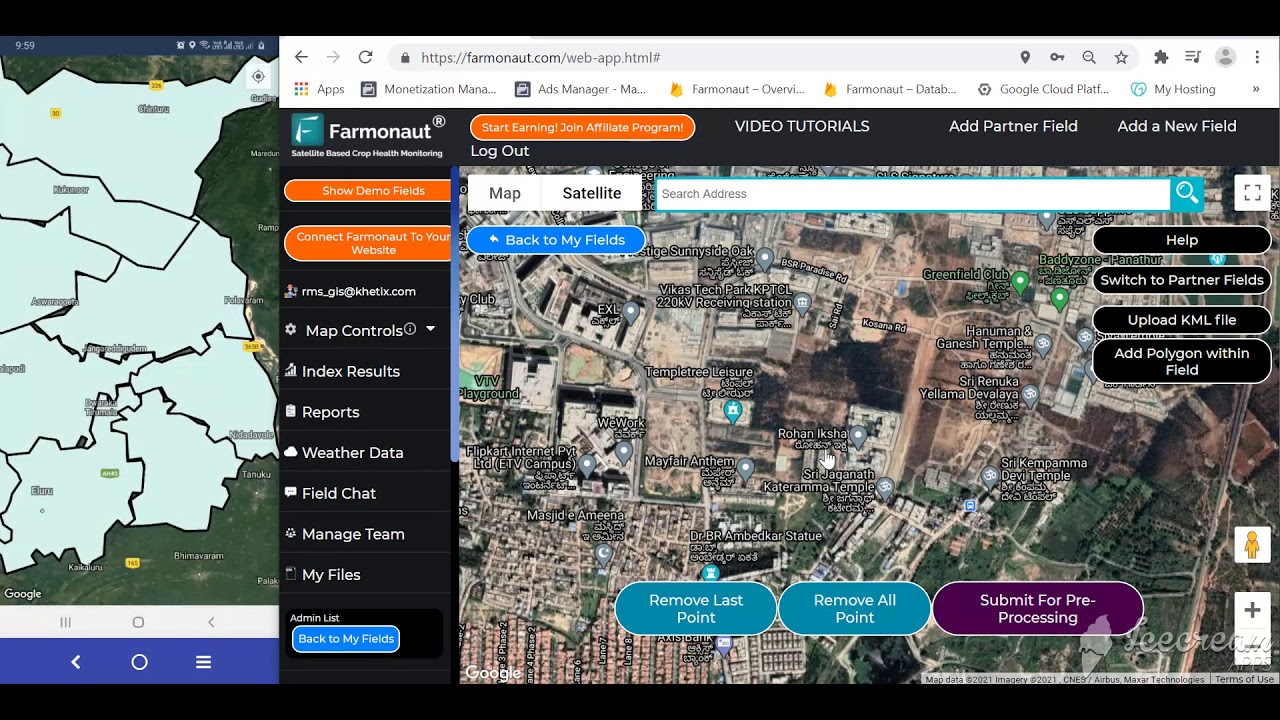
A walkthrough of field mapping and large-scale monitoring setup, applicable to forest and riparian landscapes as well as row crops.
Frequently Asked Questions
1. What is forest monitoring and what does it measure?
Forest monitoring is the repeated, dated tracking of vegetation, water, soil, and wildlife in a defined forest area to detect change against a baseline. The USDA Forest Service's LCMS system does this annually and nationally for land cover since 1985; wildlife-focused programs like BEMP add direct species counts on seasonal or annual cycles.
2. What animals live in a forest ecosystem and what roles do they play?
Forest ecosystem animals span herbivores (deer, rabbits), predators (raptors, foxes, bobcats), pollinators and seed dispersers (birds, bats), decomposers (invertebrates, scavengers), and ecosystem engineers (beavers). Each performs a distinct, measurable function — browsing pressure, population control, genetic dispersal, nutrient cycling, and habitat creation respectively.
3. How many endangered animal species are there in US forests?
The US Fish and Wildlife Service tracks 1,684 threatened or endangered species across all US taxa and ecosystems as of 2025, with 214 documented as extinct. A forest-specific subtotal is not separately published; building one requires cross-referencing individual species listings with forest habitat data via the ECOS species database.
4. What forest monitoring software or systems are available?
Public systems like the USDA Forest Service's Landscape Change Monitoring System provide free national land-cover data. Commercial platforms add parcel-level vegetation and water indices via API for active land managers who need operational, not just research-grade, monitoring.
5. How is forest ecosystem balance maintained among animal populations?
Balance depends on the interaction between herbivores, predators, pollinators, and decomposers staying proportionate, not on any single species count remaining flat. Trend monitoring — like the USDA Forest Service's 2017–2023 bird study showing 32 species increasing and 27 declining among 59 tracked — is a better balance indicator than a one-time headcount.
6. How can I monitor my own forest or plantation for wildlife and vegetation health?
Explore Farmonaut's web and mobile apps for satellite-based vegetation and water tracking, or use the calculator above to estimate pass frequency and coverage for your specific area and revisit interval.
Conclusion: A Monitoring Checklist That Doesn't Expire
The species counts in this article will change — check the US Fish and Wildlife Service's listings database quarterly for the current threatened, endangered, and extinct totals, and the USDA Forest Service's LCMS viewer annually for the newest land-cover layer. What won't change is the method: define your monitoring boundary, pick a revisit interval matched to how fast the thing you're tracking actually moves (vegetation: seasonal; water: weekly to monthly; specific wildlife: as governed by the species' own activity pattern), log the same indicator zones every cycle, and compare against your own prior year rather than a national average that may not apply to your forest type or region.
That's the same structure the Bosque Ecosystem Monitoring Program, USDA Forest Service's bird trend research, and LCMS all use — a fixed method applied consistently over time, not a single snapshot. Building or subscribing to a forest monitoring system is really a decision about which parts of that method you do yourself and which parts you get from a public program, a commercial API, or both.
Product and resource traceability tools can extend this into documentation you can hand to funders, auditors, or certification bodies — turning monitoring data into a verifiable record rather than an internal file.

 Hydenmet
 Dirks Bros Farms
 Red August Group
 Farm Inc
 WeMe Global
 Agrotoken
 Blue BearX
 Insignito
 Croptimum
 DnCubed
 Field Capacity
 Indosistim Teknologi
 Liquify Digital
 CU Foods
 BeyondTech Global
 Rouge VC
 AgroGreen Dynamics
