

Reviewed August 2026 against USDA’s Economic Research Service, Statistics Canada’s Farm Management Survey, and WIPO’s Patent Landscape Report on Agrifood.
Try it: Run your own numbers →
Agriculture Technology Solutions: UAV, IP & HMI Compared
Agriculture technology solutions now span three distinct decisions a Calgary-area farm, forestry operation, or agritech vendor actually has to make: whether a UAV/drone programme pays for itself, how to protect the software and sensor IP behind it, and which human-machine interface (HMI) standard keeps that hardware talking to everything else in the yard. The data on all three is more specific — and less hyped — than most coverage suggests: drone/aerial-imagery adoption on U.S. row crops was still in single digits as of the most recent USDA survey, Canadian field-crop farms lead the world on GPS guidance, and one interoperability standard (ISOBUS/ISO 11783) already solves most of the HMI problem for equipment buyers. This piece works through each with sourced figures, a calculator, and what to check next season when the numbers move.
Why Calgary? The Local Starting Point
- ✔ Geographical diversity: Alberta farmland runs from prairie cropland to edge-of-forest and mining-adjacent terrain, so the same UAV fleet has to handle row crops, timber stands, and reclamation surveys.
- ✔ Vibrant local markets: The Calgary Farmers’ Market gives technology-enabled producers a direct channel to show traceability and stewardship data to buyers.
- ✔ A federal agricultural pedigree: Alberta and the Prairies sit inside a national data-collection system — Statistics Canada’s Census of Agriculture — that already tracks precision-technology uptake province by province, which is more than most jurisdictions can say.

A Data-Driven Tradition Older Than the Drone
Long before UAVs, Canada had a federal push to replace pedigree-guesswork with measured records. Dr. G.S.H. Barton, inducted into the Canadian Agricultural Hall of Fame, championed production records for dairy cattle over pedigree alone while teaching at Macdonald College, then served as Canada’s Deputy Minister of Agriculture from 1932 through the Depression and the Second World War, later helping found the Food and Agriculture Organization. The specific induction year listed for Barton varies across the Hall of Fame’s own gallery and search pages — the individual inductee record linked above is the authoritative one to check directly rather than trusting a secondhand citation, including this one. The throughline to today’s UAV and satellite tools is the same: measured data beats instinct, whether the record is a milk yield or an NDVI map.
Table of Contents
- UAV Drone Agriculture: What the Adoption Data Actually Shows
- Canada’s Precision-Ag Numbers vs. the U.S.
- Forestry & Resource Land: UAVs Beyond the Row Crop
- Agritech HMI Solutions: One Screen for Every Brand
- Agritech IP Solutions: Patents, Filings, and What Actually Gets Protected
- Farmonaut: Satellite Tools That Plug Into the Same Stack
- Market Access: From the Field to Calgary’s Farmers Market
- Adoption at a Glance: A Sourced Comparison Table
- UAV Scouting Break-Even Calculator
- Frequently Asked Questions
- Conclusion
UAV Drone Agriculture: What the Adoption Data Actually Shows
Uav agritech solutions get pitched as a foregone conclusion in a lot of marketing copy. The USDA Economic Research Service’s own farm-level survey data tells a more measured story. Aerial imagery — the ERS category that covers drone and fixed-wing crop scouting — was used on 9.8% of U.S. soybean acres in 2018, 7.0% of corn acres in 2016, 4.6% of sorghum acres in 2019, 3.5% of winter wheat acres in 2017, and 2.8% of cotton acres in 2019, according to the USDA Economic Research Service, drawing on its Agricultural Resource Management Survey (ARMS). For the same 2016 corn crop, yield maps were used on 43.7% of acres and soil maps on 21.5% — both far ahead of aerial imagery. In other words: on the farm today, a combine’s yield-mapping computer and a soil-sampling programme are doing more of the precision-ag heavy lifting than a drone is, and that gap is exactly what the chart below sets out.
That gap is the actual answer to “should we add UAV scouting” for most operations: aerial imagery is a genuinely underused layer, not a saturated one, which is why the ERS explicitly frames it as “remain[ing] mostly grounded” relative to other digital tools. For a deeper technical walkthrough of the sensors, flight patterns, and data pipeline involved, see Farmonaut’s guide to UAV technology in precision farming.
How UAV Agritech Solutions Actually Work
- ✔ Programmed flights: UAVs fly pre-set routes, capturing visible, multispectral, and (on higher-end platforms) thermal imagery of the field.
- ✔ Sensor output: Multispectral bands flag chlorophyll stress, moisture deficit, and early disease signatures before they’re visible from the ground.
- ✔ Processing: Flight imagery is stitched and classified — either on a local workstation or a cloud platform — into a field map within hours of landing.
- ✔ Targeted response: The map drives variable-rate spraying or fertilizer passes instead of blanket application across the whole field.
- ✔ Documentation: Timestamped flight data doubles as a paper trail for insurance claims and regulatory compliance checks.
- Try it: Run your own numbers
Because aerial-imagery adoption is still below 10% on every major U.S. row crop surveyed by ARMS, a UAV programme is more likely to be catching problems your neighbours’ ground scouting is missing than duplicating something the industry has already standardized. Upload flight data to a processing platform the same day, while the stress signature is still fresh enough to act on.

Canada’s Precision-Ag Numbers vs. the U.S.
For Canadian readers, the more useful adoption metric isn’t drones specifically — it’s GPS guidance, which the Statistics Canada Farm Management Survey tracks at the provincial level as part of the 2021 Census of Agriculture. Nationally, 84% of field-crop farms used GPS technology in 2021 — unchanged from 2017. The Prairie provinces sit well above that: Manitoba (94%), Saskatchewan (92%), and Alberta (90%) all cleared 90%. Ontario moved from 74% in 2017 to 78% in 2021, and 37% of Quebec field-crop farms reported no GPS use at all in 2021. For the first time in the survey’s history, 14% of Canadian field-crop farms combined GPS with variable-rate pesticide application in 2021 — a genuinely new data point, not a repeat of an old one. Among forage farms specifically, GPS adoption was lower: 32% nationally and 39% across the Prairies.
The practical read for Calgary-area operations: Alberta is already at 90% GPS adoption on field crops, so the frontier for local gains isn’t guidance — it’s the layers stacked on top of it, like variable-rate application and aerial imagery, where national uptake is still in the teens or single digits. For more on how Calgary specifically is applying this, see Farmonaut’s piece on Calgary’s urban agriculture and AI adoption. UK readers should note that Defra runs a comparable annual instrument, the Farm Practices Survey, though its most recent released round focused on greenhouse-gas mitigation practices rather than precision-technology uptake — check the current Farm Practices Survey release on GOV.UK directly for whichever edition covers GPS, variable-rate, and drone adoption in England.
Forestry & Resource Land: UAVs Beyond the Row Crop
Calgary’s agritech footprint isn’t limited to cropland — it borders forestry and mining-adjacent land where UAV agritech solutions do different work entirely:
- ✔ Stand assessment: Drones map stand density and flag disease outbreaks across managed timber before a ground crew would spot them.
- ✔ Reforestation tracking: Repeat UAV flights over a burn or harvest block quantify regrowth against a planting plan.
- ✔ Reclamation compliance: Over mining-adjacent land, aerial surveys document erosion and rehabilitation progress for regulators.
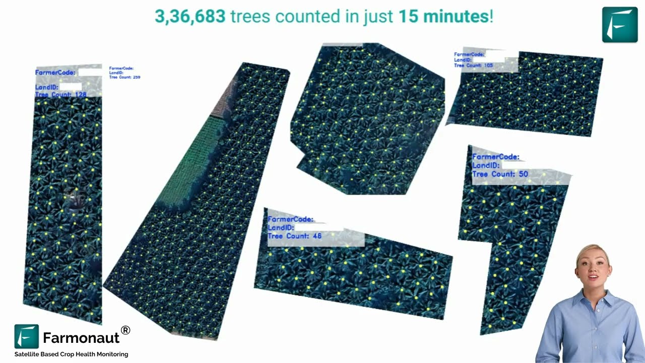
Automated tree-counting from satellite and UAV imagery turns a manual stand inventory — historically a multi-day ground survey — into a repeatable digital count that can be rerun every season to track loss, regrowth, or encroachment without resending a crew.
Agritech HMI Solutions: One Screen for Every Brand
Agritech HMI solutions answer a narrower, more mechanical question than the drone debate: how does a farmer control a UAV, a sprayer, a soil sensor array, and a satellite dashboard without learning four different interfaces? For hardware, the industry already has a working answer — ISOBUS (ISO 11783) is the international standard that lets a single in-cab terminal act as the virtual terminal for implements from different manufacturers, provided both sides are ISOBUS-compliant. The Agricultural Industry Electronics Foundation (AEF), which maintains implementation guidelines on top of the ISO standard, describes the goal plainly: “plug and play” across any tractor-terminal-implement combination. ISO itself publishes the underlying specification as ISO 11783-6, the virtual-terminal part of the family, now in its fourth edition.
That solves the hardware HMI problem. The software HMI problem — one dashboard for satellite NDVI, UAV output, weather, and soil sensor feeds — is what platforms like Farmonaut’s web app and JEEVN AI advisory layer are built to do; a farmer working across brands doesn’t need a fifth login to see the same field.

What to Check Before Buying an ISOBUS-Labeled Terminal
- ✔ Confirm the specific functionalities (task controller, section control, variable-rate) both your terminal and your implement support — “ISOBUS-compatible” is not automatically “fully interoperable” on every feature.
- ✔ The AEF maintains a public ISOBUS compatibility database for cross-checking implement and terminal pairings before purchase.
- ✔ For API-level integration rather than in-cab hardware, Farmonaut exposes its own machine interface via its satellite and weather API, documented in the developer docs — the software equivalent of an ISOBUS-compliant terminal, for teams building their own front end.
Agritech IP Solutions: Patents, Filings, and What Actually Gets Protected
Agritech IP solutions cover a real strategic question for any Calgary firm building sensor, UAV, or software products: patent it, license it, or hold it as a trade secret? The scale of the field is larger than most founders assume. WIPO’s Patent Landscape Report on Agrifood counts more than 3.5 million published patent families across the Agrifood sector over the past two decades, with AgriTech accounting for 60% of that total — roughly 2.1 million families — against 40% for FoodTech. AgriTech filings grew at a 6.9% annual rate over the report’s study window, faster than FoodTech’s 3.3%. Robotics and drone technologies alone reached about 2,900 patent families in 2022, growing at roughly 15% a year; mapping and imagery reached about 4,700 families at a similar 15% growth rate; and precision agriculture broadly reached about 4,500 families, growing near 12% a year.

One WIPO figure matters more for a small or mid-sized agritech company than the headline growth numbers: only 12% of Agrifood patent families (about 450,000) are filed outside their office of first filing. The other 88% never leave their home jurisdiction. That’s a strategy signal, not just a statistic — most agritech IP protection worldwide is domestic-only, so a Calgary company weighing a Canadian-only filing against a costlier multi-country application is following the pattern most of the sector already follows, not an outlier move. Large equipment manufacturers behave differently at scale: autonomous precision-agriculture technology reportedly accounts for roughly half of Deere’s international patent filings and around three-quarters of Kubota’s, according to D Young & Co’s analysis of agritech patent trends — a reminder that for a smaller vendor, licensing a component from a filer at that scale can be a faster route to market than trying to out-patent them.
If your UAV or sensor product depends on a proprietary image-processing pipeline rather than a physical mechanism, talk to counsel early about trade-secret protection alongside — or instead of — a patent filing. Software-heavy agritech inventions face patent-eligibility hurdles that a mechanical seed drill improvement doesn’t.
Farmonaut: Satellite Tools That Plug Into the Same Stack
Satellite monitoring is the layer that sits above UAV flights, GPS guidance, and ISOBUS-connected implements — covering the acres a drone hasn’t flown yet and refreshing without a truck roll. Farmonaut’s tools are built to sit alongside the UAV, HMI, and IP considerations above rather than replace them:
- ✔ Satellite-based crop and forestry monitoring: large-scale farm management tools deliver NDVI field-health maps, soil condition data, and vegetation-stress indicators via Android, iOS, web, or API.
- ✔ AI advisory: JEEVN AI analyzes satellite and sensor data for prairie growing conditions and diversified crops.
- ✔ Blockchain-based traceability: traceability tools let Calgary-area supply chains document origin and handling for buyers and export markets.
- ✔ Carbon footprinting: carbon-footprinting analytics quantify operational emissions for sustainability reporting.
- ✔ Fleet management: fleet tools track agricultural and forestry equipment utilization.
- ✔ API access: the Farmonaut API and its developer documentation let a team wire satellite data into a proprietary dashboard.
- ✔ Crop loan and insurance support: satellite-verified data speeds up lending and claims decisions.




Relying on ground scouting or legacy weather feeds alone for input-timing decisions ignores exactly the gap the USDA data above quantifies: yield and soil maps are already in wide use, but the imagery layer that would catch in-season stress early is still under 10% adoption on every major row crop. Combining satellite, UAV, and soil-sensor inputs closes that gap without adding a full-time scouting hire.
Market Access: From the Field to Calgary’s Farmers Market
The adoption data above matters commercially too: digital traceability tied to satellite or UAV monitoring gives producers a documented story to tell at the point of sale. At the Calgary Farmers’ Market, a QR code linking to real crop-monitoring and stewardship data is a trust signal a generic “locally grown” sign isn’t. Blockchain-based traceability ties a specific batch to its field-level record; that record is only credible if it’s built on data the producer can actually show — a soil map, an NDVI series, a flight log — rather than a claim with nothing behind it.

Adoption at a Glance: A Sourced Comparison Table
Every figure below traces to the USDA or Statistics Canada page linked above it — check those pages directly for the latest release before quoting a number publicly, since both agencies refresh these surveys periodically rather than continuously.
| Metric | Region | Survey Year | Adoption Rate | Source |
|---|---|---|---|---|
| Aerial imagery — soybeans | United States | 2018 | 9.8% | USDA ERS / ARMS |
| Aerial imagery — corn | United States | 2016 | 7.0% | USDA ERS / ARMS |
| Yield maps — corn | United States | 2016 | 43.7% | USDA ERS / ARMS |
| Soil maps — corn | United States | 2016 | 21.5% | USDA ERS / ARMS |
| Aerial imagery — winter wheat | United States | 2017 | 3.5% | USDA ERS / ARMS |
| Aerial imagery — cotton, sorghum | United States | 2019 | 2.8% / 4.6% | USDA ERS / ARMS |
| GPS guidance, field crops | Canada (national) | 2021 | 84% | Statistics Canada |
| GPS guidance, field crops | Manitoba | 2021 | 94% | Statistics Canada |
| GPS guidance, field crops | Saskatchewan | 2021 | 92% | Statistics Canada |
| GPS guidance, field crops | Alberta | 2021 | 90% | Statistics Canada |
| GPS guidance, field crops | Ontario | 2021 | 78% (up from 74% in 2017) | Statistics Canada |
| GPS + variable-rate pesticide | Canada (national) | 2021 | 14% | Statistics Canada |
| AgriTech share of Agrifood patent families | Global | 20-year window | 60% (~2.1M families) | WIPO |
| Patent families filed outside first office | Global | 20-year window | 12% (~450,000) | WIPO |
UAV Scouting Break-Even Calculator
Given how thin UAV adoption still is on most row crops, the question most operations actually need answered is whether a scouting programme pays for itself on their acreage — enter your own costs below to see the net per season.
Run your own numbers
Frequently Asked Questions
What share of farms actually use UAV drone agriculture technology?
On the U.S. row crops the USDA tracks through ARMS, aerial imagery — the category covering drone and fixed-wing scouting — sat between 2.8% and 9.8% of planted acreage depending on crop and survey year, well behind yield maps (43.7% on 2016 corn) and soil maps (21.5%). Canada’s national precision-ag tracking focuses on GPS guidance rather than drones specifically, where field-crop adoption reached 84% in 2021. Check the USDA ERS and Statistics Canada pages linked throughout this article for whichever crop, province, or year you need — both are updated on their own survey cycles, not continuously.
What do agritech HMI solutions actually standardize?
ISOBUS (ISO 11783) standardizes the connection between tractors, implements, and in-cab terminals so one virtual-terminal display can operate compliant equipment from different manufacturers. It does not automatically make every ISOBUS-labeled product fully interoperable on every function — check the AEF’s compatibility guidelines for the specific features (task control, section control, variable rate) you need before buying.
What are agritech IP solutions, in practical terms?
For a company building sensor, UAV, or software agritech products, “IP solutions” usually means choosing between a patent filing, a trade-secret approach, and a licensing arrangement. WIPO’s data shows AgriTech patent families growing at roughly 6.9% a year, with the large majority of filings (about 88%) never leaving their home jurisdiction — domestic-only protection is the norm, not the exception, for most agritech filers.
Who was Dr. G.S.H. Barton, and why does the Canadian Agricultural Hall of Fame matter here?
Dr. G.S.H. Barton taught at Macdonald College, pushed dairy producers to adopt measured production records instead of relying on pedigree alone, and later served as Canada’s Deputy Minister of Agriculture through the 1930s and the Second World War before helping found the Food and Agriculture Organization. He’s listed as an inductee on the Canadian Agricultural Hall of Fame’s own site, linked above — that page, not a secondhand summary, is the source to check for his exact induction year and gallery placement.
Can a small or mid-sized producer access these agriculture technology solutions?
Yes. Subscription-based SaaS pricing, mobile apps, and API access mean a UAV service contract, an ISOBUS-compliant terminal, or a satellite monitoring subscription no longer requires enterprise-scale capital to get started — the calculator above is built around exactly that kind of small-operation math.
Where can I go deeper on UAV, satellite, and Calgary-specific adoption?
- ✔ Farmonaut’s platform: web, Android, and iOS.
- ✔ API integration: the Farmonaut API documentation.
- ✔ UAV technical detail: Farmonaut’s precision-farming UAV guide.
- ✔ Calgary context: Farmonaut’s Calgary urban-agriculture piece.
Conclusion: What Actually Moves the Needle
The three queries behind this page resolve to three separate, checkable decisions rather than one hype narrative: aerial-imagery adoption is genuinely low on U.S. row crops (2.8%–9.8% depending on crop), which means the opportunity there is real rather than exhausted; HMI is already substantially solved by ISOBUS for hardware and by unified dashboards like Farmonaut’s for software; and IP strategy for most agritech firms defaults to domestic-only filing, per WIPO’s own data, which is a normal choice rather than a compromise. None of those figures are static — USDA re-runs ARMS on a rolling schedule by crop, Statistics Canada updates its Farm Management Survey roughly every five years alongside the Census of Agriculture, and WIPO periodically refreshes its Agrifood patent landscape data. Bookmark the source links above rather than this page’s numbers, and re-check them before the next planting season, tender, or filing decision.
Ready to move from adoption data to your own field data?
- ✔ Launch the Farmonaut platform for crop, forestry, and resource management.
- ✔ Integrate the Farmonaut API with your own agritech stack or dashboard.
- ✔ Measure your carbon footprint for premium market certification.
- ✔ Build traceability for export-market readiness.
- ✔ Manage your fleet across field, forest, or reclamation sites.

 Godrej Agrovet
 Hayleys Agriculture
 Linx Agritech
 Adinet
 Save Your Soils
 GalaxEye Space
 Grandstream Algérie
 XOS Realty
 Geospatial Lab Africa
 Agro La Gándara
 HIPSAC
 ZOL Zimbabwe
 Juligerm
 AdBio
AdBio MISE Maroc
 NWNS
NWNS Red August Group
 Farm Inc
 WeMe Global
 Agrotoken
 Blue BearX
 Insignito
 DnCubed
 Indosistim Teknologi
 Liquify Digital
 CU Foods
 BeyondTech Global
 Rouge VC
 AgroRisk
 Oath Inc
 Esri North East Africa
 MDCV UK
 Etech Consulting Madagascar
 Vestlandsforsking
 WB Dev
 Sama Premium
 Tres Valles
 Blickwinkel
 Agricultural Credit Policy Council
 eKGIS
eKGIS Mostas Tech
 Andex
Andex Deluxe Conseil
 WICO
WICO Chimera Innovation
 SkyHarvest
 Teledarbas
 Exurbia Geospatial
 FieldZero
