

Uranium exploration · Athabasca Basin
Athabasca Basin Uranium: Deposits, Owners and MARS Claims
The Athabasca Basin is a roughly 100,000 km² sandstone basin in northern Saskatchewan whose unconformity uranium deposits, such as Cigar Lake at 16.33% U3O8 in reserves, are the highest-grade in the world.
Key takeaways
- The Athabasca Basin is not the largest uranium deposit by tonnage (that is Olympic Dam in Australia), but reserve grades of 6% to 16% U3O8 at its main mines are far above other districts.
- Ore sits near the unconformity between 1.76 to 1.50 billion-year-old sandstone and older basement gneiss, either just above it or in faulted basement below it.
- Cameco operates McArthur River and Cigar Lake; Denison’s Phoenix and NexGen’s Arrow are at the CNSC construction stage; Paladin’s Triple R is still proposed.
- Claims are taken online in MARS: C$0.60 per hectare to register, no work in year one, then C$15 per hectare a year to year ten.
- Satellites map structure, exposed alteration, glacial landforms and access. They cannot see ore 50 to 800 m down under sandstone and till.
In this article
- What the Athabasca Basin is, and why the grades are so high
- Unconformity versus basement-hosted targets in the Athabasca Basin
- Athabasca Basin uranium mines, projects and owners
- Athabasca Basin map: where to see deposits, claims and geology
- Staking Athabasca ground in MARS: fees, work and permits
- Structural targeting: from conductors to drill holes
- What satellites can and cannot see in the Athabasca Basin
- Largest versus highest-grade: the world's uranium deposits in context
- Frequently asked questions about the Athabasca Basin
The Athabasca Basin is a district where a single drill intercept can define a company, because the uranium is so concentrated. Reserves at Cameco’s Cigar Lake average 16.33% U3O8, and the World Nuclear Association puts most Canadian resources at about one hundred times the world average grade. This guide is written for the people who hold, buy, drill or finance ground in the basin: it explains the deposit model, the difference between unconformity and basement-hosted targets, who owns what, what a MARS claim costs, how structural targeting works, and what satellite data can and cannot tell you through sandstone and glacial cover.
If you are new to resource reporting, our guide to NI 43-101 rules, qualified persons and resource categories explains the terms used below. For licensing systems in other countries, see the mining cadastre portal guide by country.
Cigar Lake’s reserve grade of 16.33% U3O8 is more than 500 times that of Kazakhstan’s Inkai in-situ recovery mine.
What the Athabasca Basin is, and why the grades are so high
Start with the size. A Canadian Institute of Mining paper by F.F. Langford describes the Athabasca Basin as about 100,000 km² of north-west Saskatchewan, with its western edge running roughly 50 km into Alberta. It is filled with mainly fluvial sandstone up to 1,600 m thick. A provincial and Alberta Geological Survey compilation dates those sandstones to between 1,760 and 1,500 million years ago and calls the basin host to the world’s largest high-grade unconformity-related uranium deposits.
The Geological Survey of Canada’s Bulletin 588 review by Jefferson and co-authors is the standard reference for how those deposits look. It describes pods, veins and semi-massive replacements of uraninite (pitchblende) close to the unconformity between the flat-lying sandstone and much older metamorphosed basement. Beneath the unconformity, red hematitic and bleached clay-altered rock grades down through chlorite-altered gneiss into fresh basement. Graphitic metapelite, a carbon-rich metamorphosed mudstone, preferentially hosts the reactivated shear zones that carry many of the deposits.
Why does that produce such high grades? The review’s model is a meeting of two very different fluids at a structural trap. Oxidised, uranium-bearing brines moved through the porous sandstone; reducing conditions sat in or came up from the graphitic basement along faults. Where the two met at a reactivated fault crossing the unconformity, uranium dropped out of solution in a small volume. The result is a deposit that is small in footprint and extreme in grade, the opposite of the bulk-tonnage deposits mined elsewhere.
The World Nuclear Association’s Canada profile puts it simply: the majority of Canada’s uranium resources sit in high-grade deposits some one hundred times the world average, and many need ground freezing to mine safely. That is why Athabasca Basin uranium is mined with frozen ground, remote equipment and jet boring rather than conventional stoping.
Unconformity versus basement-hosted targets in the Athabasca Basin
Two target styles now share the basin, and they call for different drilling. The GSC review describes a range from polymetallic lenses that sit just above or straddle the unconformity, often with nickel, cobalt, arsenic and lead, to monometallic veins hosted in the basement below it. Cigar Lake is the classic first style: Cameco mines it about 480 m below surface, in soft sandstone at the unconformity that has to be frozen before it is cut.
The second style has driven most new discoveries in the past decade. NexGen describes its Arrow deposit as hosted entirely in basement rock, and Paladin says the Triple R deposit at Patterson Lake South is hosted in basement rock, starting just 50 m from surface. Both sit in the south-west of the basin, where the sandstone is thin or absent. The World Nuclear Association notes Arrow starts about 100 m down and runs to about 800 m.
For a land manager, the practical difference is depth and drill cost. An unconformity target under 500 m of sandstone means every hole is long and slow before it reaches the zone that matters. A basement target near the basin edge can be tested with shorter holes, but the mineralisation can continue hundreds of metres down along steep structures, so the resource definition program becomes the expensive part.
Chart
How deep the ore sits
Approximate metres below surface, top and bottom of ore or mining levels
- ✔ Unconformity targets follow the contact surface. Drill to the unconformity, then look for alteration, structure and uranium in the 50 to 100 m around it.
- ✔ Basement-hosted targets follow steep graphitic shear zones below the unconformity. Holes need to be angled across the structure, not just down to the contact.
- ⚠ Thin-sandstone edges put the target closer to surface; check MARS for open ground before you plan anything.
- Unconformity lenses can carry nickel, cobalt, arsenic and lead, while the GSC review describes basement-hosted veins as generally monometallic.
Athabasca Basin uranium mines, projects and owners
Ownership in the basin is concentrated. The Canadian Nuclear Safety Commission, which licenses all current and future uranium mines and mills in Canada, lists Cigar Lake, McArthur River, Key Lake, McClean Lake and Rabbit Lake as licensed operating facilities, Wheeler River (Denison) and Rook I (NexGen) at the site preparation and construction stage, and Patterson Lake (Paladin) as proposed. All of them are in northern Saskatchewan.
Cameco’s mineral reserve table at 31 December 2025 gives the two flagship numbers. Cigar Lake holds 479,000 tonnes at 16.33% U3O8 for 172.4 million pounds (100% basis). McArthur River holds 2.43 million tonnes at 6.48% for 346.5 million pounds. Those are proven plus probable reserves, priced at about US$63 per pound; measured, indicated and inferred resources are reported separately and are not added to them here.
Chart
Average reserve grade, % U3O8
Proven + probable (or probable) mineral reserves as reported by each owner
| Mine or project | Owner(s) and operator | Style and depth | Status (Oct 2026) | Owner-reported figure |
|---|---|---|---|---|
| McArthur River (mill: Key Lake) | Cameco 69.8% (operator), Orano 30.2% | High-grade ore 530 to 640 m below surface | Operating; ore trucked 80 km to Key Lake | P&P reserves 346.5 Mlb at 6.48% (Dec 2025) |
| Cigar Lake | Cameco 57.4% (operator), Orano the balance | At the unconformity, about 480 m | Operating; ore milled at McClean Lake | P&P reserves 172.4 Mlb at 16.33% (Dec 2025) |
| McClean Lake mine and mill | Orano 70% (operator), Denison 22.5%, OURD 7.5% | Shallow unconformity pods | Mining resumed in 2025 | Mill processes all Cigar Lake ore |
| Rabbit Lake | Cameco 100% | Eastern basin margin | Care and maintenance since 2016 | Indicated 38.6 Mlb at 0.95% (resource) |
| Millennium | Cameco about 70%, JCU about 30% | Basement-hosted | Development halted in 2014 | Indicated 75.9 Mlb at 2.39% (resource) |
| Phoenix (Wheeler River) | Denison 90%, JCU 10% | Unconformity; in-situ recovery planned | CNSC site preparation and construction stage | P&P reserves 56.7 Mlb at 11.7% (Jun 2023) |
| Arrow (Rook I) | NexGen Energy | Basement-hosted, about 100 to 800 m | CNSC site preparation and construction stage | Measured 209.6 Mlb at 4.35% (resource) |
| Triple R (Patterson Lake South) | Paladin Energy | Basement-hosted, from 50 m | Proposed; provincial EIS approved Feb 2026 | Probable reserves 93.7 Mlb at 1.41% |
Sources: Cameco reserve table and operation pages; World Nuclear Association (ownership splits for McArthur River, McClean Lake and Millennium); Denison, NexGen and Paladin project pages; CNSC facility list. Reserves and resources are kept separate and are 100% basis.
Several changes since older articles on this topic matter. Paladin Energy completed its acquisition of Fission Uranium on 24 December 2024, so Triple R is no longer a Fission project. Rabbit Lake has been on care and maintenance since the second quarter of 2016. At McClean Lake, the province reported in August 2025 that mining and milling had resumed under the Orano and Denison joint venture.
Denison reports Phoenix reserves of 219,000 tonnes at 11.7% U3O8 for 56.7 million pounds, effective 23 June 2023, to be mined by in-situ recovery inside a freeze wall. It would be the first in-situ recovery uranium mine in the Athabasca Basin region. NexGen’s Rook I page lists Arrow resources only (measured 209.6 Mlb at 4.35%, indicated 47.1 Mlb at 1.36%, inferred 80.7 Mlb at 0.83%), so we quote those as resources, not reserves.
Production follows the same concentration. The World Nuclear Association’s company data show Canada’s output coming almost entirely from McArthur River and Cigar Lake since Rabbit Lake stopped in 2016, with a gap when McArthur River was suspended from 2018 until its 2022 restart. The province reported a record 16.7 thousand tonnes of uranium production in 2024, up 28% on 2023, and calls itself the world’s second-largest uranium producer.
Chart
Two mines carry Canada’s uranium output
Tonnes U3O8 per year, 100% basis, 2013 to 2022
Athabasca Basin map: where to see deposits, claims and geology
Most searches for an Athabasca Basin map want one of three things: the outline of the basin and its geology, where the uranium deposits are, or which ground is already held. Each has a different official source, and none of them needs a paid subscription.
- 📊 Geology and outline: the 1:500,000 Geology and Mineral Resources of the Athabasca Basin and Environs map (Saskatchewan Geoscience Map 2010-1 and ERCB/AGS Map 538) shows the Athabasca Group formations, a 25 km band of surrounding shield geology, mineral occurrences and drill holes that reach the unconformity.
- 📊 Deposit outlines: the Geological Atlas of Saskatchewan carries an Athabasca deposit footprints layer of 53 polygons for deposits with past production or an NI 43-101 measured resource.
- 📊 Occurrence records: the Saskatchewan Mineral Deposit Index holds a record for each showing, prospect and deposit, with references to assessment work.
- 📊 Who holds the ground: MARS shows active dispositions on surveyed parcels and unsurveyed grid cells; this is the map to check before you plan any program.
Read the maps together and a pattern jumps out. The producing mines and most of the deposit footprints cluster along the eastern margin of the basin, from Key Lake north through McArthur River and Cigar Lake to McClean Lake and Rabbit Lake, while the newer basement-hosted discoveries line up near the south-western edge around Patterson Lake.
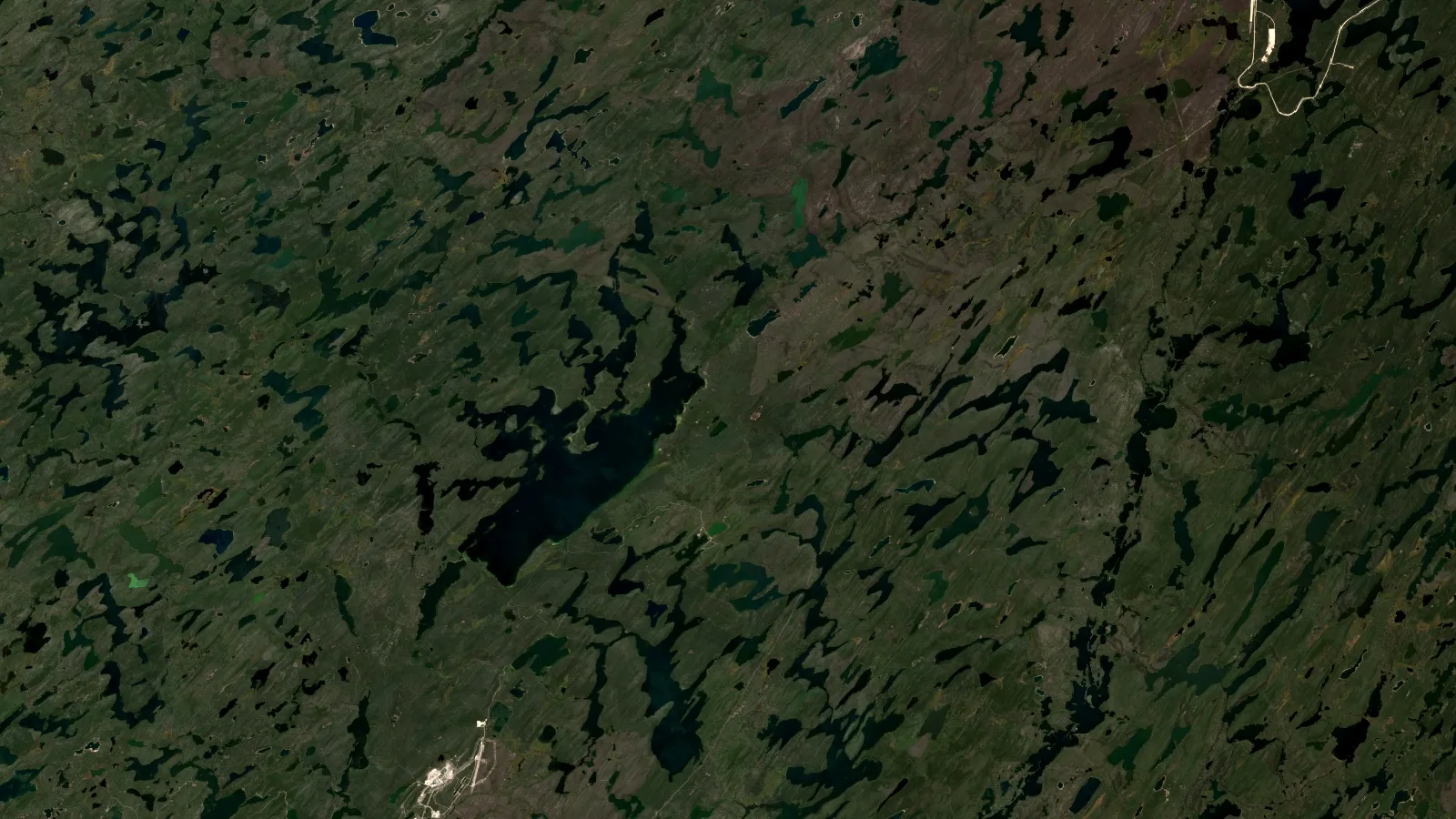
The satellite image at the top of this page is a Sentinel-2 summer composite of the eastern basin. In it you can see what a field crew will meet: forest, lakes and ridges stretched in one direction by glacial ice, patches of brown, thinly vegetated ground, mine roads and pads at the lower left and upper right, and very little bare rock. That is the cover the next two sections have to deal with.
Staking Athabasca ground in MARS: fees, work and permits
Saskatchewan stopped ground staking in December 2012. Claims are now acquired online through the Mineral Administration Registry Saskatchewan (MARS), which uses surveyed cadastral parcels in the south and unsurveyed legal subdivision grid cells, built by ISC, across the north. Almost all Athabasca Basin ground falls in the unsurveyed grid. You register an account, select open parcels on the map, and pay the registration fee.
The numbers come from Table 2 of The Mineral Tenure Registry Regulations, consolidated to Saskatchewan Regulations 62/2024. A claim may not exceed 6,000 hectares, and its length may not exceed six times its width. Registration costs C$0.60 per hectare with a C$300 minimum. The term is one year, continued year to year while the holder meets expenditure requirements: nothing in the first assessment work period, then C$15 per hectare (minimum C$240 per claim) for periods two to ten, and C$25 per hectare (minimum C$400) from period eleven on.
Large programs can use a permit instead. The same table sets a permit registration fee of C$0.30 per hectare (minimum C$3,000), a C$30,000 performance cash deposit, and work of C$5.25 per hectare during the term; a permit can later be converted to claims at C$0.60 per hectare. General information, not legal advice; confirm current fees and rules with the Saskatchewan Ministry of Energy and Resources.
Infographic
From open ground to a uranium mine licence in Saskatchewan
- 1Check open groundMARS parcel map, the Saskatchewan Mineral Deposit Index and the deposit footprints layer.
- 2Register a claimC$0.60 per hectare (minimum C$300), up to 6,000 ha per claim.
- 3Meet work requirementsNo work in year one, then C$15 per hectare a year (minimum C$240) to year ten.
- 4Permits and consultationMinistry of Environment surface permits; the Crown’s duty to consult may apply.
- 5Drill and file workAssessment reports keep the claim in good standing.
- 6Mine stageProvincial environmental assessment plus a CNSC licence to prepare and build.
Calculator
What does it cost to hold an Athabasca claim block?
Enter your land package, number of claims and years held. Amounts in Canadian dollars (C$).
- Registration fee (C$): $3,000
- Work commitment (C$): $300,000
- Average per hectare per year: 12.12 C$/ha/yr
- Land package in acres: 12,355 acres
Canadian dollars (C$). Registration C$0.60 per hectare (minimum C$300 per claim); no work in the first assessment period; C$15 per hectare (minimum C$240 per claim) in periods 2 to 10; C$25 per hectare (minimum C$400 per claim) from period 11, per Table 2 of The Mineral Tenure Registry Regulations (consolidated to SR 62/2024). One claim may not exceed 6,000 ha, so the claim count is raised to at least area / 6,000. Area is split evenly. Excludes surveys, permits, deposits and drilling. Example values only. General information, not legal advice; confirm with the Ministry of Energy and Resources.
At the defaults, a single 5,000-hectare claim held for five years costs C$3,000 to register and commits C$300,000 of exploration work, because years two to five each need C$75,000. That is C$303,000 in total, or about C$12 per hectare per year. Splitting the same ground into more claims changes little until the per-claim minimums start to bite on very small claims.
Holding a claim does not let you disturb the ground. The Mineral Exploration Guidelines for Saskatchewan require surface disturbance permits from the Ministry of Environment before exploration work on Crown land, and an application can trigger the Crown’s duty to consult. The province says it holds that duty to consult First Nation and rights-bearing Métis communities, under a revised Consultation Policy Framework in effect since 1 January 2024, and encourages proponents to engage early.
In the eastern basin, the producing companies also work under a regional agreement. The Ya’thi Néné Collaboration Agreement, signed on 22 June 2016, links Cameco and Orano (then AREVA) with the Black Lake, Fond du Lac and Hatchet Lake Denesuline First Nations and the communities of Stony Rapids, Wollaston Lake, Uranium City and Camsell Portage. Juniors are not party to it, but it is useful context for any explorer planning community engagement in the region.
Federal licensing starts later than many juniors assume. The CNSC says surface exploration for uranium is exempt from the Nuclear Safety and Control Act because it poses low risk; provinces regulate it. Advanced work, such as a ramp into a mineralised zone, can need a CNSC licence, and every mine and mill needs one from site preparation onward.
Structural targeting: from conductors to drill holes
Money is flowing back into this work. The province estimates uranium exploration spending rose from C$75 million in 2021 to about C$250 million in 2025, after an estimated C$200 million in 2024.
Chart
Uranium exploration spending in Saskatchewan
Millions of Canadian dollars (C$), provincial estimates
The targeting logic follows the deposit model. Because graphitic metapelite hosts many of the reactivated shear zones, electrical conductivity is the first filter: airborne and ground electromagnetic surveys trace graphitic conductors through the basement, under the sandstone. Our explainers on geophysical survey methods and resistivity and IP cover the instruments. In the sandstone above a deposit, clay alteration and silicification change resistivity too, which is why resistivity surveys follow the conductors.
A typical sequence for a junior looks like this:
- Regional compilation. Basement geology, aeromagnetic data, historical drill holes to the unconformity and the deposit footprints layer.
- Conductor mapping. Airborne electromagnetics to find graphitic trends, then ground surveys to fix their position and dip.
- Structure. Breaks and offsets in the conductors, cross-faults and magnetic lows where fluids may have moved.
- Alteration vectors. Clay species, boron (dravite) and pathfinder elements in sandstone core, boulders and till.
- Drilling. Fences of holes across the best structural intersections, logged for alteration as carefully as for uranium.
Glacial cover complicates the surface part of that sequence. A University of Waterloo study of the McArthur River area, a deposit about 550 m deep, describes a corridor of elongated drumlins and long dispersal trains left by a major ice stream flowing toward the south-west. It warns that differences in till composition can mask the magnetic and geochemical anomalies explorers rely on. Boulder and till sampling still works, but only if you know which till sheet you are sampling and which way the ice moved.
For drilling costs and contractors, see our pages on exploration drilling methods and costs and airborne geophysical survey contractors.
What satellites can and cannot see in the Athabasca Basin
Let us be direct about the limits first. Sentinel-2, the free optical satellite most explorers start with, records four bands at 10 m, six at 20 m (including the two short-wave infrared bands) and three at 60 m. Optical and short-wave infrared sensors measure light reflected from the top millimetres of whatever is at the surface. In the Athabasca Basin that surface is mostly forest, lakes, muskeg and glacial till, with ore 50 to 800 m below. No satellite sees uranium ore at those depths, through sandstone, till or water.
Snow and ice cover the ground through the northern winter, so useful optical scenes come mainly from the summer months, and cloud or wildfire smoke can cut that window further. A single 20 m short-wave infrared pixel covers 400 m², which blends outcrop, soil, moss and trees into one spectrum. Those are honest limits, and any report that ignores them should worry you.
What satellites do well here is everything around the target:
- ✔ Structure. Long lineaments in lake chains, valley lines and drainage that can follow basement faults, mapped consistently over a whole claim group.
- ✔ Ice-flow direction. Drumlin orientation shows which way the ice moved, which tells you where to look up-ice of a boulder or till anomaly.
- ✔ Exposed alteration. Where sandstone or basement does crop out, short-wave infrared bands can separate clay-rich and iron-stained surfaces from fresh rock, as a screen for field checks.
- ✔ Burn scars and access. Recent fires expose more ground and change access; satellite time series show both, along with winter roads, trails and lake access for camps.
- ⚠ Change over time. Disturbance from past programs, old drill pads and trenches is visible, which helps when you buy ground with incomplete records.
Use these layers to decide where geophysics and ground crews go first, not to replace them. A satellite structure map laid over an electromagnetic conductor map is where the two methods start to earn their keep together.
Ore at McArthur River lies 530 to 640 m below surface, far beyond what any optical satellite can detect.
We build these surface layers as part of our satellite-based mineral detection service. You send your claim outline as coordinates, KML, KMZ or a polygon, plus the target mineral (uranium is on our list of detectable materials). We choose multispectral or hyperspectral data, map alteration patterns, faults and fractures, and rank zones by prospectivity. The report comes with heatmaps, estimated location and depth ranges, and georeferenced GIS files that drop straight into the same project as your geophysics, in 5 to 20 business days depending on area and mineral.
The Premium+ report adds TargetMax drilling intelligence: suggested drilling angles and interactive 3D subsurface models of vein structures. Across our work we have scanned more than 100,000 hectares for 20+ mineral types in 25+ countries, and satellite screening can cut early-exploration timelines from months to days and early-exploration cost by up to 80 to 85%. On ground like the Athabasca Basin we say plainly where cover limits the read. Our results are exploration targets that sit ahead of any resource estimate; they are not NI 43-101 disclosure and not a guarantee of a find.
Largest versus highest-grade: the world’s uranium deposits in context
Searches for the world’s largest uranium deposits often land on the Athabasca Basin, and the answer needs care. By size, the largest single known uranium deposit is Olympic Dam in South Australia, which an Australian parliamentary committee report described as the world’s largest uranium deposit, mined for copper, gold and uranium together. By grade, nothing matches the Athabasca Basin. Cameco’s own table makes the contrast: its Inkai in-situ recovery operation in Kazakhstan has reserves of 241 million pounds at 0.03% U3O8, while Cigar Lake holds 172 million pounds at 16.33%.
That contrast is the reason contained-pound arithmetic matters so much in the basin. The calculator below turns tonnes and grade into pounds of U3O8 and a gross value at a price you choose.
Calculator
How many pounds of U3O8 does a zone hold?
Enter tonnes, grade, recovery and an example price. Values are in US dollars (US$).
- Contained U3O8: 2,204,620 lb
- Recovered U3O8: 2,160,528 lb
- Contained U3O8 in tonnes: 1,000.0 t
Pounds of U3O8 = tonnes x grade (%) / 100 x 2,204.62. The default price of US$90/lb is an example near Cameco’s month-end spot indicator of US$89.63/lb on 30 September 2026; check today’s price. Default recovery sits just below the 98.9% (Cigar Lake) and 99.2% (McArthur River) planned recoveries in Cameco’s 2025 reserve table. Gross value in US dollars (US$) only: no mining, milling, royalty or tax costs and no dilution. Arithmetic only, not a resource estimate and not investment advice.
At the defaults, 100,000 tonnes at 1.0% U3O8 contains 2,204,620 pounds. At 98% recovery that is 2,160,528 pounds, worth about US$194.4 million gross at US$90 per pound, an example close to Cameco’s month-end spot indicator of US$89.63 on 30 September 2026 (its long-term indicator was US$96.50). Change the grade to 16% and the same tonnage holds about 35 million pounds, which is why a few metres of very high grade in one hole can move a share price.
Use the result as arithmetic only. A resource needs drill density, density measurements, geological continuity and a qualified person’s estimate under NI 43-101; reserves need at least a prefeasibility study on top. Our page on scoping, prefeasibility and feasibility studies explains what each step adds, and the in-situ leaching guide covers the extraction method Phoenix plans to use. Not investment advice.
Frequently asked questions about the Athabasca Basin
Where is the Athabasca Basin?
In the north-west corner of Saskatchewan, with its western margin running about 50 km into Alberta. It covers roughly 100,000 km² of sandstone resting on older Canadian Shield basement, south of Lake Athabasca.
Why is Athabasca Basin uranium so high-grade?
Uranium-bearing brines in the sandstone met reducing conditions at reactivated faults in graphitic basement rock, right at or below the unconformity. Uranium precipitated in small, concentrated pods and veins, giving reserve grades such as 16.33% at Cigar Lake and 6.48% at McArthur River (Cameco, December 2025).
Is the Athabasca Basin the world’s largest uranium deposit?
No. The largest single known deposit is Olympic Dam in South Australia. The Athabasca Basin holds the world’s highest-grade deposits, which is why it produces so much uranium from a small volume of ore.
Which uranium mines operate in the Athabasca Basin?
The CNSC lists McArthur River, Key Lake (mill), Cigar Lake, McClean Lake and Rabbit Lake as licensed operating facilities. Rabbit Lake is on care and maintenance; McArthur River, Cigar Lake and McClean Lake are producing.
Which Athabasca Basin uranium companies are building new mines?
Denison Mines (Phoenix, part of Wheeler River) and NexGen Energy (Arrow, the Rook I project) are at the CNSC site preparation and construction stage. Paladin Energy’s Patterson Lake South (Triple R) is listed as proposed. Not investment advice.
What is the difference between unconformity and basement-hosted uranium deposits?
Unconformity deposits sit just above or straddle the contact between sandstone and basement, often with nickel, cobalt and arsenic. Basement-hosted deposits, such as Arrow and Triple R, are veins and zones in faulted basement rock below the contact and can extend hundreds of metres down.
How do you stake a uranium claim in Saskatchewan?
Register an account in MARS, select open parcels or grid cells on the map (up to 6,000 hectares per claim), and pay C$0.60 per hectare with a C$300 minimum. There is no physical staking. Confirm current rules with the Ministry of Energy and Resources.
How much does it cost to keep a claim in the Athabasca Basin?
No work is required in the first year. From year two to year ten you must record C$15 per hectare of work a year (minimum C$240 per claim), then C$25 per hectare from year eleven. A 5,000-hectare claim held five years commits about C$300,000 of work plus C$3,000 to register.
Where can I find an Athabasca Basin uranium map?
Use the Saskatchewan and Alberta 1:500,000 Athabasca Basin compilation map for geology, the Geological Atlas of Saskatchewan’s deposit footprints layer for deposit outlines, the Saskatchewan Mineral Deposit Index for occurrences and MARS for current claims.
Do I need a CNSC licence to explore for uranium?
Not for surface exploration, which the CNSC says is exempt from the Nuclear Safety and Control Act and regulated by the province. Advanced exploration, such as underground access to a mineralised zone, may need a CNSC licence, and every mine and mill does.
Can satellites find uranium in the Athabasca Basin?
Not directly at depth. Ore lies 50 to 800 m below sandstone, till and forest. Satellites map structures, glacial ice-flow direction, exposed alteration, burn scars and access, which help decide where geophysics and drilling go first.
General information, not legal, tax or investment advice. Claim rules and fees change; confirm with the Saskatchewan Ministry of Energy and Resources. Farmonaut is not a licensing agent, land-title adviser, broker or investment adviser. Farmonaut results are exploration targets ahead of any resource estimate.
Farmonaut mineral detection
Map your Athabasca claims from space
Send your claim boundary as KML, KMZ or a polygon. Farmonaut returns ranked satellite exploration targets for it, usually in 5 to 20 business days.

Keep reading
Sources
- Cameco, Mineral reserves and resources at 31 December 2025 (2026): cameco.com
- Cameco, Cigar Lake operation page (2026): cameco.com
- Cameco, McArthur River/Key Lake operation page (2026): cameco.com
- Cameco, Rabbit Lake care and maintenance page (2026): cameco.com
- Cameco, Uranium price month-end indicators (Sept 2026): cameco.com
- Geological Survey of Canada, Jefferson et al., Bulletin 588, Unconformity-associated uranium deposits of the Athabasca Basin (2007): doi.org
- CIM, Langford, Geology of the Athabasca Basin (1986): onemine.org
- Saskatchewan Energy and Resources and Alberta Geological Survey, Athabasca Basin compilation map 2010-1 / Map 538 (2010): ags.aer.ca
- World Nuclear Association, Uranium in Canada (2026): world-nuclear.org
- Canadian Nuclear Safety Commission, Uranium mines and mills (2026): cnsc-ccsn.gc.ca
- Government of Saskatchewan, The Mineral Tenure Registry Regulations, consolidated to SR 62/2024: publications.saskatchewan.ca
- Government of Saskatchewan, Mineral Administration Registry Saskatchewan (MARS): saskatchewan.ca
- Government of Saskatchewan, Mineral Exploration Guidelines for Saskatchewan (2016): publications.saskatchewan.ca
- Government of Saskatchewan, Duty to consult First Nation and Métis communities: saskatchewan.ca
- Government of Saskatchewan, Uranium production and sales reach all-time highs (April 2025): saskatchewan.ca
- Government of Saskatchewan, 54th Saskatchewan Geological Open House release (December 2025): saskatchewan.ca
- Government of Saskatchewan, Uranium production resumes at McClean Lake (August 2025): saskatchewan.ca
- Geological Atlas of Saskatchewan, Athabasca deposit footprints metadata: gisappl.saskatchewan.ca
- Government of Saskatchewan, Saskatchewan Mineral Deposit Index: mineraldeposits.saskatchewan.ca
- Denison Mines, Phoenix mineral reserves and resources (2023): denisonmines.com
- NexGen Energy, Rook I project (2026): nexgenenergy.ca
- Paladin Energy, Patterson Lake South project (2026): paladinenergy.com
- Paladin Energy, Completion of acquisition of Fission Uranium, ASX release (24 Dec 2024): announcements.asx.com.au
- Cameco North, Ya'thi Néné Collaboration Agreement story (2016): cameconorth.com
- University of Waterloo, Scott and Ross, Quaternary stratigraphy of the McArthur River mine area (2016): cmic-footprints.laurentian.ca
- Parliament of Australia, House committee uranium report, chapter 3: aphref.aph.gov.au
- Copernicus SentiWiki, Sentinel-2 mission: sentiwiki.copernicus.eu
Discussion
Questions, corrections or field experience? Share them below. First-time comments are reviewed before they appear, and your email is never published.
No comments yet. Be the first to add a question or your experience.

 Energy and Resources Ltd
 Mwerezi Minerals Company Limited
 Congo Mining Solutions
 Mining SARL
 SenGold Invest SAS
 Sania Corporation
 Sean Mining Limited
 NTS Group (Pty) Ltd
 Mine4Africa
 Lithspo Minerals Limited
 Tintina Mining Group
 Dalgety Minerals Pty Ltd
 Vortex Minerals Pty Ltd
 Faith At Work (Pty) Ltd
 Geotech Mining Solutions plc
 Vulcan International Limited
 Kidepo Associates
 GKY Mining
 Alkimy SARL
