

Diamond geology · Coordinates list
Best Coordinates for Diamonds: 16 Real Locations
The best coordinates for diamonds are known kimberlite pipes such as Jwaneng, Botswana (-24.523, 24.702). This guide lists 16 checkable sites with current status, then shows how geologists find new ground.
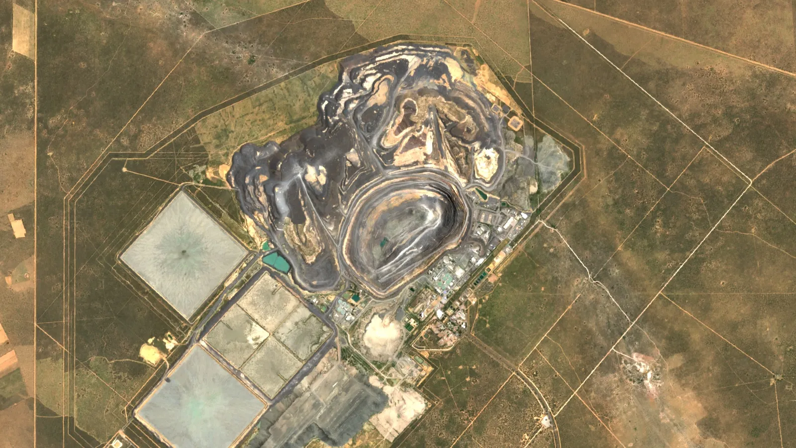
Key takeaways
- No coordinate holds diamonds by itself: only about 50 economic kimberlite deposits have been found since the 1870s (GIA, 2016).
- Diavik closed in March 2026 and Ekati entered receivership in July 2026, so older lists of Canadian mines are out of date.
- Russia leads gem-quality output at about 21 million carats, of about 69 million worldwide (USGS, 2025 estimate).
- Most ore bodies hold under 1 to about 6 carats per ton (USGS, 2026).
- Arkansas’s Crater of Diamonds is the public search site; the other locations are private or restricted.
In this article
- Real Diamond Mine Coordinates You Can Check Right Now
- Diamond Formation and Geological Contexts: Understanding Where Diamonds Occur
- Primary Diamond Deposits: The Depths of Kimberlite Pipes
- Secondary or Alluvial Diamond Placers: Diamonds in Rivers and Sediments
- Geological Indicators and Exploration Signatures for Diamonds
- Modern Geomapping and Sampling Best Practices
- Alluvial Sampling: Managing Diamonds and Sediment in Rivers
- Alluvial Search-Grid Calculator
- Coordinate Ranges by Terrain and What Each One Means
- Who Produces the Most, and Why That Differs From the Best Spot
- What to Check Before You Act on Any Coordinate
- Responsible Resource Management in Diamond Mining
- Environmental Stewardship and Ecosystem Considerations
- Infrastructure Planning: Access and Productivity
The best coordinates for diamonds are the mapped positions of known kimberlite pipes, because no latitude or longitude holds diamonds by itself. Jwaneng in Botswana (-24.523, 24.702) is the classic example, and the table below lists 16 places you can paste into any map. A kimberlite is the volcanic rock that carries diamonds up from the mantle, and a pipe is the carrot-shaped column it leaves behind.
That rarity is the real story. Geologists counted only about 50 economically mineable kimberlite deposits worldwide since the 1870s, according to a GIA Gems & Gemology study of the Diavik mine. So the useful question is not only where diamonds were found but what marks the ground around them. This page answers both, for consultants, licence holders and anyone screening ground. If you came here for the video game Minecraft, the short answer is in the FAQ.
Real Diamond Mine Coordinates You Can Check Right Now
Each row gives decimal latitude and longitude. South and west are negative. Paste the pair into a map and switch to satellite view. Most of these show an open pit, or the workings around one. Positions are reference points from public mine pages on Wikipedia, so treat them as accurate to the site, not to a single pipe.
Chart
Gem-quality diamond output by country
Million carats, 2025 estimate, seven largest listed
| Site | Country | Lat, lon | Host rock | Status and owner (sources checked November 2026) |
|---|---|---|---|---|
| Jwaneng | Botswana | -24.523, 24.702 | Kimberlite pipe | Debswana (De Beers and the Botswana government); 13.3 million carats in 2023 |
| Orapa | Botswana | -21.308, 25.369 | Two kimberlite pipes joined near surface | Debswana; 1.18 sq km at surface |
| Letlhakane | Botswana | -21.520, 25.689 | Kimberlite | Debswana; open pit ended 2017, tailings now processed |
| Catoca | Angola | -9.399, 20.301 | Kimberlite pipe | Joint venture led by state company Endiama |
| Cullinan (Premier) | South Africa | -25.673, 28.513 | Kimberlite pipe | Underground; source of the 3,106-carat Cullinan diamond |
| Finsch | South Africa | -28.382, 23.446 | Kimberlite pipe | Underground mine near Lime Acres |
| Williamson (Mwadui) | Tanzania | -3.517, 33.600 | Kimberlite pipe | Petra Diamonds 75%, Tanzanian government 25%; mothballed April 2020, confirm current status |
| Diavik | Canada (NWT) | 64.496, -110.273 | Four kimberlite pipes under Lac de Gras | Closed March 2026 after 23 years; in reclamation |
| Ekati | Canada (NWT) | 64.714, -110.619 | Kimberlite field | Receivership since July 2026; shutdown and reclamation |
| Gahcho Kué | Canada (NWT) | 63.434, -109.186 | Kimberlite pipes under Kennady Lake | De Beers 51%, Mountain Province Diamonds 49%; opened 2016 |
| Victor | Canada (Ontario) | 52.817, -83.906 | Kimberlite pipes, Attawapiskat field | De Beers; closed 2019 |
| Udachny | Russia (Yakutia) | 66.434, 112.318 | Kimberlite pipe | Alrosa |
| Aikhal | Russia (Yakutia) | 65.927, 111.497 | Kimberlite pipe | Alrosa |
| Mir | Russia (Yakutia) | 62.526, 113.984 | Kimberlite pipe | Alrosa; open pit closed 2001, underground from 2009, flooded 2017, 468-carat stone reported 2025 |
| Argyle | Australia | -16.712, 128.398 | Lamproite pipe | Rio Tinto; mining ended November 2020 after 865 million carats |
| Crater of Diamonds | USA (Arkansas) | 34.032, -93.670 | Eroded volcanic crater | State park; public search field |
Three things stand out. First, the sites cluster on old, thick continental blocks rather than scattering evenly. Second, status changes quickly: two of the three big Northwest Territories mines left production in 2026, with Rio Tinto reporting Diavik’s last ore in March 2026 and a court appointing a receiver over Ekati in July 2026. Third, the coordinates grant nothing. All but one of these sites are private mine property or held under mineral title, and you cannot walk onto them to search.
A coordinate list also misleads in one way. A country’s total output depends on far more than one pipe, as the production figures below show. USGS estimates that the world mined about 69 million carats of gem-quality natural diamond in 2025, with Russia near 21 million and Angola, Botswana and Canada near 13 million each (USGS Mineral Commodity Summaries, 2026). A carat is 0.2 grams.
Diamond Formation and Geological Contexts: Understanding Where Diamonds Occur
Horizontal position matters only because of what lies beneath it. Diamonds grow deep in the mantle, in the cold, thick roots under ancient continental blocks called cratons. The GIA study describes these blocks as very old crust with some 150 to 200 km of mantle attached below. Kimberlite magma, which comes from even deeper, then passes through that root and picks up diamonds on its way to surface.
This sequence gives three rules for reading any map:
- Old craton first. Diamond-bearing kimberlites favour Archean rocks, meaning those older than about 2.5 billion years. Diavik sits in the Slave craton, and the GIA paper links it to the same ancient setting as southern African kimberlites.
- A pipe is needed. Without a kimberlite or a similar rock to carry them, diamonds stay in the mantle. Argyle in Australia shows that the carrier can also be lamproite, a related volcanic rock.
- Erosion moves the prize. Once a pipe weathers, its diamonds can travel in rivers, on beaches and with ice. That gives a second type of target far from the source.
Two points a short distance apart can therefore have very different value. Mountain Province reports that the Gahcho Kué kimberlites cover under 0.02 sq km inside a 12 sq km mine site, in a territory of about 1.35 million sq km (Mountain Province Diamonds). That ratio shows why the search is a narrowing process and not a lookup.
Most pipes do not pay either. More than 500 kimberlite pipes have been identified in Canada, and more than half of them contain at least traces of diamonds, GIA reports. Yet only a handful became mines. For grade, meaning how much diamond the ore holds, USGS says most ore bodies range from under 1 carat to about 6 carats per ton.
Primary Diamond Deposits: The Depths of Kimberlite Pipes
A primary deposit is the pipe itself. These are the sites most people mean when they ask for coordinates. Pipes are compact, so mines stay in one place for decades and go deep. Orapa, described as the largest diamond mine by area, covers just 1.18 sq km at surface, and it sits on two pipes that merge near the top.
The carrot shape has a practical result. A pipe narrows with depth, so ore per vertical metre falls as the mine goes down while the cost of reaching it rises. Many operations start as open pits and move underground, as Mir and Cullinan did. Pipes also come in groups. Diavik has four within 4 km of one another, and the Attawapiskat field around Victor holds 18 pipes, 16 of them diamond-bearing.
Geological Indicators in Kimberlite Exploration
Diamonds are too rare to sample directly at the regional stage, so explorers look for companion minerals that are far more abundant. GIA lists the classic set as chromium-rich pyrope garnet (red), chromium diopside (green), olivine (green), ilmenite (black) and chromium spinel (black). Chromium diopside is especially useful because it does not survive long transport, so a fresh grain suggests the source is close.
Secondary or Alluvial Diamond Placers: Diamonds in Rivers and Sediments
A secondary or alluvial deposit, also called a placer, forms when erosion frees diamonds from a pipe and water carries them away. The search then changes from finding one small body to tracing a trail, and a position is only useful for a stretch of a particular channel. Value can be good because transport tends to break weaker stones, but the deposit is usually thin and patchy, so sampling density decides whether results mean anything.
Not every diamond field is a neat pipe or river, either. De Beers lists Namibia among its host countries, a reminder that diamonds also occur in coastal settings, where old river loads were reworked by the sea (De Beers operations).
For the public in the United States, the practical example is Arkansas. Crater of Diamonds State Park lets visitors search a 37-acre plowed field, the eroded surface of a volcanic crater, and keep what they find. The park reports more than 37,377 diamonds found by visitors since 1972, as of January 2026, including the 40.23-carat Uncle Sam (Arkansas State Parks). Strictly, this field is an eroded primary source rather than a river placer, which is why it is so unusual.
Where Diamonds Accumulate in Alluvial Settings
- Where flow slows. Heavy minerals drop out on the inside of bends and behind bars or boulders.
- On bedrock traps. Cracks, potholes and riffles in the rock under the gravel hold heavy grains.
- In old terraces. Benches above the modern river record where it once ran.
- In paleochannels. These are abandoned, often buried river courses. They may never appear on a modern river map, so test pits or drilling must confirm them.
Geological Indicators and Exploration Signatures for Diamonds
Professionals reach a target by stacking independent evidence. Canada’s Lac de Gras discovery is the textbook case, and the GIA paper records it in detail.
- Follow the grains. Prospectors found indicator minerals in the Mackenzie River valley and worked out that glaciers had moved them from sources farther east. They then sampled glacial sediment and eskers, the long gravel ridges left by meltwater streams.
- Close in. After about a decade of work across 1,200 km, Chuck Fipke found a bright green chromium diopside crystal at Point Lake in April 1990, and the first pipe followed. In November 1991, BHP reported 81 small gem-quality diamonds in core from that pipe, which triggered the biggest land rush in Canadian history.
- Fly the ground. Aber staked 3,250 sq km at Diavik by early 1992 and began a helicopter magnetic survey. Kimberlite often gives a magnetic, gravity or electrical contrast with the rock around it.
- Drill the anomaly. An anomaly is only a measured oddity until it is tested. At Diavik, core drilling of what became the A154 South pipe returned kimberlite holding a 2.5-carat crystal.
Canadian pipes often weather faster than the rock around them, so few reach the surface as outcrop and many lie under lakes. That is why a gravity survey and magnetic data carry so much of the work there. If you need names rather than methods, see our list of diamond exploration companies.
▶ Remote sensing for mining explained: the instrument families and why agreement between them matters. · 2:01
Modern Geomapping and Sampling Best Practices
A sensible programme moves from cheap and wide to costly and narrow. Each step should be able to end the project.
Infographic
From map to target in 5 steps
- 1Screen the cratonCheck rock age and past finds on survey maps.
- 2Read the landUse satellite images for drainage, structure and access.
- 3Sample mineralsTrace indicator grains back up-ice or upstream.
- 4Run geophysicsLook for magnetic, gravity or electrical anomalies.
- 5Drill and bulk sampleCore the anomaly, then test stone size and value.
Satellite data fits at the start. It cannot see a diamond or confirm a pipe, but it can map terrain, drainage, surface alteration and structure over a whole licence, and show which parts deserve a field crew. Our satellite based mineral detection work is one option for that first screen. Results are exploration targets only and sit ahead of any resource estimate. For the wider process, read about exploration targeting.
Core Practices for Locating Diamond-Bearing Rock
- Check the basement age on a geological survey map before spending anything.
- Sample heavy minerals up-ice or upstream in a planned sequence, and record the exact position of each sample.
- Have grains examined for mineral chemistry, since not every garnet or spinel came from a diamond-bearing source.
- Test each geophysical anomaly with core, then take a larger bulk sample before quoting any value. Diamond value depends on stone size and quality, and small drill samples say little about either.

▶ What AI does and does not do in mineral exploration, and how to check a claim. · 4:37
Alluvial Sampling: Managing Diamonds and Sediment in Rivers
Alluvial work is a sampling-density problem. Results from a few pits on a large gravel body can mislead in both directions, because stones are few and unevenly spread. Mapping bars, bends and bedrock highs first lets you place pits where the river actually dropped its heavy load. Keep records of gravel thickness, overburden and pit location alongside any recovery, since the economics depend on how much waste must be moved per carat.
Sediment also needs managing. Digging in or next to a channel can send silt downstream, so settling ponds and agreed water-quality checks belong in the plan and the permit. In most countries, river work needs its own water permit as well as mineral title.
Alluvial Search-Grid Calculator
Use this to estimate the number of test pits, crew days and budget for a simple rectangular grid over one stretch of old channel. Enter your own channel size, spacing and local costs.
Calculator
How many test pits does your channel need?
Enter your channel size, spacing and local costs.
- Crew days: 26.2
- Pit budget (US$): $31,500
Example values only, not a benchmark or a recommended spacing. Costs are your own inputs in US$. The grid is rectangular and covers one reach; it excludes access, permits and downtime.
Coordinate Ranges by Terrain and What Each One Means
The same coordinate means something different in each setting. This table shows what a position actually tells you and how to test it.
| Setting | Reference location | What the position marks | Main evidence | Next test |
|---|---|---|---|---|
| Single large pipe | Jwaneng, -24.523, 24.702 | A compact body under Kalahari cover | Indicator minerals, geophysics | Core, then bulk sample |
| Pipe cluster under water | Diavik, 64.496, -110.273 | Several pipes within a few km | Glacial trains, magnetics | Core through the lake ice or from shore |
| Pipe field in lowlands | Victor, 52.817, -83.906 | 18 known pipes in one field | Airborne geophysics | Core, then bulk sample |
| Eroded crater | Crater of Diamonds, 34.032, -93.670 | A weathered surface over a volcanic source | Visible host rock | Surface searching under park rules |
| River or terrace gravel | A stretch of channel, never one point | Where a river once dropped heavy minerals | Heavy mineral samples, old drainage maps | Pit grid, as in the calculator |
Who Produces the Most, and Why That Differs From the Best Spot
Production figures and coordinates answer different questions. USGS data shows gem-quality output led by Russia, while industrial natural diamond splits differently, with Russia at about 16 million carats, Congo (Kinshasa) at 7 million, and Botswana and Zimbabwe at 5 million each in 2025 (USGS, Diamond (Industrial), 2026). Canada, in contrast, appears as a gem producer, and two of its largest mines have just left production.
Chart
Gem-quality diamond reserves
Million carats, USGS 2026 edition, countries with a USGS figure
Chart
Gem versus industrial natural diamond output
Million carats, 2025 estimate, selected countries
Reserves show where future supply sits: USGS gives Russia 750 million carats of gem-quality reserves, ahead of Botswana at 250 million and Angola and Congo (Kinshasa) at 150 million each. USGS also says natural deposits have been found in more than 35 countries, so the list of known sites is wider than the famous names. For regional context, see our Canada mineral deposits map and the guide to types of ore deposits.
What to Check Before You Act on Any Coordinate
If a seller, promoter or online post offers a location, run these checks. They apply to anyone reviewing a licence or a claim for sale.
- Title. Pull the licence from the official mining register. Confirm the holder, the boundary, the expiry date and whether the minerals in question are covered.
- Geology. Confirm old craton or a credible river path from a known source. A claim on young rock with no transport route needs a very good explanation.
- Evidence. Ask for raw sample locations, laboratory reports and drill logs. A rounded stone in someone’s hand says nothing about where it came from.
- Legal trade. Rough diamonds cross borders under the Kimberley Process certificate scheme, so check how any stones could legally be sold.
- Economics. Grade alone does not decide value. Stone size, quality, depth, access and power all matter, and a low-carat mine can beat a higher-grade one.
- People and land. Check Indigenous and community agreements, surface rights and protected areas. Canadian closure agreements at Diavik involved the Tłı̨chǫ government and the North Slave Métis Alliance, which shows how central these partners are.
Remember too that the search itself needs permission. Enter land only with consent and the right licence, respect safety rules around pits and water, and never use mercury.
Responsible Resource Management in Diamond Mining
Closure costs are real and need planning from the first day. Rio Tinto says closure work was built into Diavik’s mine plan from the start, and it is now returning lake water to the mine pits and testing it before reconnecting them to Lac de Gras. At Ekati the receivership is backed by $325 million in reclamation security, according to public reports of the court process. Anyone valuing a diamond asset should treat reclamation as a liability on the balance sheet, not a footnote.
Environmental Stewardship and Ecosystem Considerations
Water is usually the main issue. Pipes under lakes require dikes and careful water treatment, and alluvial workings can load rivers with sediment. Baseline water and soil data collected before ground is disturbed gives you something to measure against later. Remote camps also carry a fuel burden, which is why Diavik built a wind farm in 2012 that Rio Tinto says generated over 200 million kilowatt-hours during operations.
▶ The main environmental impacts of mining, explained simply. · 2:31
Infrastructure Planning: Access and Productivity
Location decides cost. Diavik and its neighbours relied on seasonal ice roads, and in 2006 the road froze late and thawed early, forcing supplies to be flown in. A pipe in that setting must be richer than one near a highway and grid power. When you compare two coordinates, also compare distance to road, power, water and skilled labour, and whether access is year-round. Satellite imagery is a quick way to check tracks, river crossings and seasonal flooding before a site visit.
Indigenous and Cultural Considerations
A pin on a map says nothing about who has rights to that land. Gahcho Kué means “place of the big rabbit” in Dene Suline, and the area has long been used by Dene and Métis people. Before fieldwork, identify the rights holders, engage early, map heritage sites and agree how benefits and complaints will be handled. Rules differ by country, so take local legal advice.
Frequently Asked Questions
What are the best coordinates for diamonds?
For a real-world reference, use known pipes such as Jwaneng (-24.523, 24.702) or Orapa (-21.308, 25.369) in Botswana. They mark mines, not open ground. New targets come from geology and sampling, not from a coordinate list.
What is the best place to find diamonds yourself?
In the United States, Crater of Diamonds State Park near Murfreesboro, Arkansas (34.032, -93.670). The park describes it as the only place in the world where the public can search for natural diamonds in their original volcanic source, and you keep what you find.
What coordinates are diamonds at in Minecraft?
In the game, the X and Z position does not matter much; height does. The Minecraft Wiki says deepslate diamond ore is most common at Y=-58 and Y=-59, and ore generates from Y=16 down to Y=-63 (Minecraft Wiki). The rest of this page is about real mines.
Can I just go to a diamond mine’s coordinates and look?
No. Operating and closed mines are private, hazardous sites under title or reclamation. Visiting without permission is trespass in most places, and taking material from a licence can be theft.
Which country has the most diamonds?
Russia, on USGS figures. It leads gem-quality production at about 21 million carats in 2025 and gem-quality reserves at 750 million carats.
Are there diamonds in Canada’s Northwest Territories today?
Yes, but the industry has shrunk. Diavik closed in March 2026 and Ekati went into receivership in July 2026. Mountain Province describes Gahcho Kué as its joint venture with De Beers, and it holds a 49% share.
What rock tells you diamonds may be present?
Kimberlite first, and lamproite in some places such as Argyle. Red chromium-rich garnet and green chromium diopside in sediment are the classic field clues, but they show that a kimberlite is near, not that it holds diamonds.
How deep are diamonds found?
They form in the mantle below old continents, in a root that the GIA study places at some 150 to 200 km deep, but they are mined much nearer the surface. Argyle’s open pit reached about 600 m, for example.
Can satellites find diamonds?
Not directly. Satellite images help you screen terrain, drainage and structure and decide where to sample. Indicator minerals, geophysics and drilling still have to confirm a pipe.
How rich is a typical diamond ore body?
USGS says most range from under 1 carat to about 6 carats per ton of ore. That is a very small amount of diamond, and value per carat varies widely by stone.
From Named Coordinates to a Real Target
Use the table to see what a diamond district looks like, then use the method to judge new ground: craton age, a credible source, indicator minerals, geophysics, then drilling and bulk samples. If you have a licence area to review, send it through our mining query form or contact us.
More from Farmonaut: best coordinates to find diamonds top 2026 insights.
This page is for information only. It is not investment or legal advice. Confirm rules with the regulator. Search only with permission and the right licence, follow safety rules and never use mercury.
Farmonaut mining
Map your own project area from space
Request a quote to have a licence area screened by satellite before you plan a sampling programme.

Mining Pro sample view, synthetic data
Keep reading
Sources
- GIA, Gems & Gemology: Diamonds from the Canadian Arctic, Diavik (2016): gia.edu
- USGS, Mineral Commodity Summaries 2026: Gemstones: pubs.usgs.gov
- USGS, Mineral Commodity Summaries 2026: Diamond (Industrial): pubs.usgs.gov
- Rio Tinto, Diavik operations: riotinto.com
- Arkansas State Parks, Crater of Diamonds: arkansasstateparks.com
- Mountain Province Diamonds: mountainprovince.com
- De Beers Group, our operations: debeersgroup.com
- Minecraft Wiki, Diamond Ore: minecraft.wiki
- Wikipedia, Diavik Diamond Mine: en.wikipedia.org
- Wikipedia, Ekati Diamond Mine: en.wikipedia.org
- Wikipedia, Gahcho Kué Diamond Mine: en.wikipedia.org
- Wikipedia, Jwaneng diamond mine: en.wikipedia.org
- Wikipedia, Orapa diamond mine: en.wikipedia.org
- Wikipedia, Argyle diamond mine: en.wikipedia.org
- Wikipedia, Catoca diamond mine: en.wikipedia.org
- Wikipedia, Mir mine: en.wikipedia.org
Discussion
Questions, corrections or field experience? Share them below. First-time comments are reviewed before they appear, and your email is never published.
No comments yet. Be the first to add a question or your experience.

 Geoticgy
 GemSprout Metals Limited
 Qader Group
 Ileys General Trading
 SG Gold Mining LLC
 VRV Global Pte Ltd
 Omsri International FZE
 G.I.T.T.
 Jaunita Erss Ltd
 Almosi SARL
 SRK Consulting
 Berks Gold Limited
 Mwerezi Minerals Company Limited
 Mining SARL
 SenGold Invest SAS
 Sean Mining Limited
 NTS Group (Pty) Ltd
 Mine4Africa
 Lithspo Minerals Limited











