

Soil Mapping & Digital Survey: 7 Powerful Trends for 2026
Summary: Soil Mapping and Digital Innovations Transforming Modern Agriculture in 2025
“Global digital soil mapping market projected to exceed $1.5 billion by 2026, up from $780 million in 2022.”
“Over 60% of precision farming operations will use advanced soil mapping technology by 2025.”
Table of Contents
- Introduction: Why Soil Survey and Mapping Matter
- Seven Powerful Trends Shaping Soil Mapping & Digital Surveys for 2026
- How Digital Soil Mapping Revolutionizes Modern Agriculture
- DJI & Drone Agriculture Mapping: The New Age of Surveying
- Our Perspective: Satellite-Driven Soil Survey & Precision Solutions by Farmonaut
- Drone Mapping Pricing & Accessibility for 2026
- The Future Landscape: Integrating Soil Data with Smart Farming
- Trend Comparison Table
- Key Insights, Pro Tips & Highlights
- FAQ: Soil Mapping & Digital Surveys 2026
- Farmonaut App, API & Product Links
- Farmonaut Subscription Plans
- Conclusion
Introduction: Why Soil Survey and Mapping Matter
In the rapidly evolving landscape of modern agriculture, the foundation of sustainable and precision farming rests on our ability to understand the soil beneath our feet. Soil mapping and soil survey and mapping techniques have long been the cornerstone of effective land management, guiding everything from crop selection to input application. As we approach 2026, the intersection of technology and soil science has unlocked a new era: digital soil mapping, drone agriculture mapping, and AI-driven analytics now enable farmers to unlock unprecedented levels of productivity and sustainability.
Accurate soil mapping is no longer just an advantage—it’s a necessity for modern agriculture. The transition to digital solutions and real-time data is revolutionizing crop yields, operational efficiency, and sustainable land use.
- ✔ Soil Mapping: Systematic collection and representation of soil types and properties
- ✔ Digital Soil Mapping (DSM): Merges soil science, remote sensing, and GIS for precise, spatial soil data
- ✔ Drone Mapping: High-resolution aerial surveys delivering real-time data for dynamic management
- ✔ Farm Management Platforms: Integrate soil data, input recommendations, and automated advisory
- ✔ Sustainable Agriculture: Reduces input waste, enhances fertility, and supports environmental conservation

Seven Powerful Trends Shaping Soil Mapping & Digital Surveys for 2026
Let’s explore the seven most impactful trends transforming soil mapping, soil survey and mapping, and digital soil mapping as we move toward 2026. These innovations are equipping agronomists, data scientists, and farmers with powerful tools for precision land management and long-term sustainability.
1. High-Resolution Remote Sensing
- 📊 Data Insight: Satellite imagery now delivers soil texture, moisture, and nutrient maps at resolutions below 5 meters per pixel.
With advancements in multispectral sensors and remote sensing, soil mapping now leverages global satellite constellations to collect and distribute accurate data. Companies like Farmonaut enable farmers and agencies to access high-resolution (large scale farm management) maps for targeted input decisions.
2. AI-Based Soil Analysis
- 🤖 Smart Automation: Machine learning models rapidly analyze imaging, zoning fields, and flagging anomalies in fertility or moisture patterns.
Digital soil mapping powered by AI delivers predictive insights into nutrient deficiencies, soil compaction, and input requirements. These models ingest vast datasets from sensors, historical records, and weather patterns, transforming the way we evaluate and utilize soil resources.

3. Drone-Guided Survey Mapping
- 🚁 Rapid Surveying: Multispectral and hyperspectral drone sensors deliver actionable spatial data within hours, even for large properties.
DJI mapping and drone-based platforms have revolutionized field data collection – reducing the cost and time of manual sampling, and making precision agriculture truly scalable. Drone mapping pricing models are now affordable for a majority of farmers and businesses.
4. Blockchain-Based Traceability in Soil Data
- 🔗 Security First: Immutable blockchain records transparency from field sampling to final crop yield, locking in trust for supply chains and environmental audits.
Farmonaut’s traceability solutions mean that soil maps, fertilizer use, and field interventions are traceable, supporting sustainable certification, insurance, and better decision-making for every stakeholder.
5. Real-Time Soil Health & Carbon Footprinting
- 🌱 Sustainability: Carbon monitoring and organic matter assessment for regenerative and climate-smart agriculture practices.
With sophisticated sensors and AI, farmers can now track carbon sequestration, organic matter trends, and monitor soil health in near-real time. Carbon footprinting platforms like Farmonaut’s carbon tool are reshaping sustainability strategies for farms worldwide.
6. Integration with Farm Management Platforms & APIs
- 🧑💻 Data-Driven Farming: Seamless access to soil mapping APIs and field management dashboards advances collaborative precision farming.
Farmonaut’s API empowers developers and businesses to integrate soil data into their own platforms. This drives innovation in input application, crop modeling, and risk management.
7. Next-Gen Sampling: IoT, Robotics & Automated Field Collection
- 🤖 Field Automation: IoT soil probes, autonomous drones, and robotic samplers accelerate the frequency and depth of field data collection.
The future is hyper-connected: soil surveys using automated probes and drones can transmit real-time, high-frequency data, allowing continuous optimization of input use, irrigation, and crop planning—no more waiting for end-of-season reports!

- High-Resolution Remote Sensing
- AI-Based Soil Analysis
- Drone-Guided Survey Mapping
- Blockchain-Based Traceability
- Real-Time Soil Health Monitoring
- Farm Management Integration
- IoT & Robotic Sampling
How Digital Soil Mapping Revolutionizes Modern Agriculture
Soil mapping and soil survey and mapping have transitioned from static maps and manual samples to dynamic, AI-enhanced digital workflows. Today’s DSM (Digital Soil Mapping) approach blends soil science with geospatial technology, enabling precision farming and sustainable management at scales never before possible.
- 📊 Rapid Digital Transformation: Large datasets from satellites, drones, and sensors are modeled with machine learning for detailed, spatially continuous maps.
- 📈 Higher Crop Yields: By understanding soil texture, nutrient distributions, and moisture zones, farmers apply exactly what each field section needs.
- 🌱 Sustainability: Less fertilizer waste, better irrigation targeting, and proactive land stewardship reduce environmental footprints.
The digital soil mapping market‘s rapid growth is a clear indicator of the agricultural sector’s digital transformation—creating significant investment opportunities in geospatial analytics, remote sensing, and smart agriculture technologies.
DSM platforms are not only powering agronomic recommendations; they are also influencing insurance underwriting, regulatory compliance, and financing (crop loan & insurance verification).
DJI & Drone Agriculture Mapping: The New Age of Surveying
The democratization of aerial soil surveying owes much to the rise of DJI drones and specialist drone agriculture mapping service providers. These tools empower farmers with rapid, high-resolution field analytics at an unprecedented scale and speed.
Before investing in drone mapping services, evaluate your area size, required resolution, and specific analytics (like NDVI, nutrient mapping, or topography) to select optimal drone mapping packages for your farm’s needs.
- 🚀 Rapid Data Collection: Survey up to 200 hectares in a single flight with drones equipped with multispectral, thermal or LIDAR sensors.
- 🎯 Actionable Insights: Identify nutrient hotspots, compaction, erosion, and moisture stress in real time, with spatial precision unobtainable using field labor alone.
- 💸 Cost-Effective: Modern drone mapping pricing makes advanced data affordable for both smallholders and large agribusiness.
- 📅 Frequent Updates: Drones enable weekly or monthly monitoring, ensuring input application always matches current field conditions.
- 🗺️ Effortless Integration: Export maps to your GIS or digital farm management platforms for seamless precision application.

Our Perspective: Satellite-Driven Soil Survey & Precision Solutions by Farmonaut
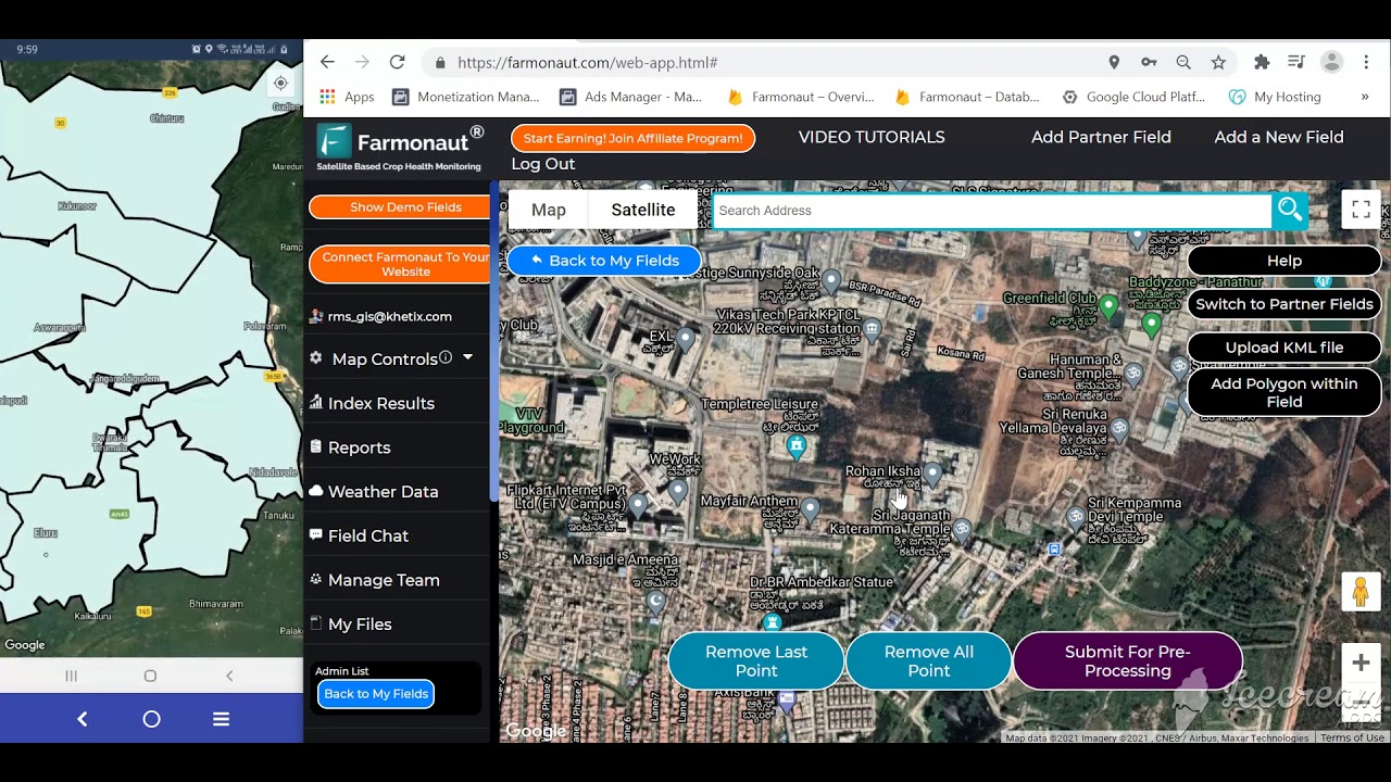
At Farmonaut, we believe in making satellite-driven insights accessible and affordable for all stakeholders in agriculture and allied sectors. Our platforms leverage multispectral satellite imagery, AI, and machine learning to deliver high-resolution, actionable soil and crop information for precision management.
- 🌍 Global Coverage: Monitor soil and crop health remotely anywhere in the world.
- ⚡ Real-Time Monitoring: Our apps deliver dynamic insights for operational efficiency on Android, iOS, and web—check out our easy-to-use platforms below.
- 🔗 Transparency & Traceability: Integrated blockchain solutions for end-to-end chain of custody and regulatory compliance.
- 🚚 Resource Optimization: Fleet management tools for maximized logistics and cost savings.
- 💡 AI-Powered Advisory: Jeevn AI supplies personalized guidance, weather forecasts, and strategic resource allocation.



Drone Mapping Pricing & Accessibility for 2026
As drone agriculture mapping adoption grows, pricing is increasingly competitive. Entry-level drone soil mapping services now start at $5–$15 per acre, with price points scaling for multi-sensor, analytics-driven packages. This flexibility ensures accessibility for both large and small-scale farming operations.
- 💰 Basic Drone Mapping: $5–$15/acre (soil texture, elevation, moisture)
- 📊 Advanced Packages: $20–$50/acre (multispectral, nutrient mapping, prescription maps)
- 📉 Group/Cooperative Discounts: Local agri-cooperatives are lowering costs for smallholders via bulk mapping
- ⏱ Rapid ROI: Reduced input costs, better yields, and lower risk absorb mapping investments often within a single season.
Don’t base drone mapping package selection on price alone. Match your field size, crop type, and management goals with the mapping resolution, sensor type, and data reporting included in each service.
The Future Landscape: Integrating Soil Data with Smart Farming
The fusion of digital soil mapping, drone surveying, and AI platforms is rapidly creating a “digital twin” for every farm field. This enables site-specific input recommendations, near real-time monitoring, and continuous learning—a revolution for precision farming in 2026 and beyond.
Key enhancements for the coming years include:
- ✔ Seamless Data Integration across satellite, drone, and IoT channels
- ✔ Personalized Advisory delivered via app-based platforms and AI chat
- ✔ Automated Input Application directed by live soil and crop status
- ✔ Continuous Sustainability Auditing using carbon metrics and blockchain history
- ✔ Advanced Resource Management powered by traceable, validated data
A growing number of agribusinesses are integrating APIs for real-time soil, crop, and weather data, optimizing irrigation, input planning, and crop choice at the touch of a button.
“Over 60% of precision farming operations will use advanced soil mapping technology by 2025.”
Trend Comparison Table: 7 Powerful Soil Mapping & Digital Survey Trends (2026)
| Trend Name | Description | Technology Involved | Estimated Adoption Rate by 2026 (%) | Impact on Precision Farming | Sustainability Benefit |
|---|---|---|---|---|---|
| High-Resolution Remote Sensing | Captures detailed soil attributes with satellites for large fields. | Satellite imagery, Multispectral sensors | 75% | Broad, precise field data for tailored management | Reduces chemical use, supports conservation |
| AI-Based Soil Analysis | Automates sampling and interprets complex data patterns quickly. | AI, Machine Learning, Satellite/Drone data | 63% | Automates decision-making; boosts efficiency | Encourages input optimization |
| Drone-Guided Survey Mapping | Rapid, high-res aerial soil surveys on-demand. | Drones, DJI technology, Onsite sensors | 66% | Real-time, spatial analysis for micro-management | Reduces field passes and emissions |
| Blockchain Traceability in Soil Data | Ensures immutable, tamper-proof soil input records. | Blockchain, Data management platforms | 43% | Secures audit trails and value-chain trust | Supports certification schemes and microloans |
| Real-Time Soil Health & Carbon Footprinting | Live monitoring of organic matter, nutrients, and carbon. | IoT Sensors, Satellite, AI | 50% | Dynamic input adjustment, monitors sustainability goals | Advances carbon sequestration and reporting |
| Integration with Farm Management Platforms & APIs | Aggregates soil maps with crop, weather, and resource data. | APIs, Data Platforms, Cloud Computing | 61% | Streamlines operations and remote management | Minimizes resource waste and boosts stewardship |
| IoT & Robotic Field Sampling | Automates, scales, and standardizes soil data collection. | IoT Probes, Robotics, AI | 37% | Drives real-time adjustments | Reduces labor, improves data accuracy |
Key Insights, Pro Tips & Highlights for 2026
- ⚠ Risk: Overlooking soil pH or ignoring organic matter in zone management can negate the benefits of precision mapping.
- 🚩 Warning: Outdated manual field sampling alone cannot keep up with the spatial and temporal demands of modern practices.
- 🔍 Check: Always validate mapping data with local soil samples before major investment or land conversion decisions.
- 💼 Strategy: Use blockchain-powered traceability to verify compliance with international food safety, sustainability, and carbon standards.
- 📈 Optimize: Schedule drone or satellite mapping before each planting and following major weather events for maximum outcomes.
By 2026, it’s projected that over 40 million hectares globally will have detailed, digital soil mapping coverage—boosting food security and sustainability on an unprecedented scale.
FAQ: Soil Mapping & Digital Survey Innovations 2026
What is the main difference between traditional soil mapping and digital soil mapping?
Traditional soil mapping relies on manual field sampling and paper maps, while digital soil mapping (DSM) integrates satellite, drone, and sensor data with AI modeling for continuous, high-resolution spatial predictions of soil properties.
How does drone agriculture mapping compare to satellite-based soil surveys in agriculture?
Drone agriculture mapping offers ultra-high spatial and temporal resolution for targeted fields and rapid response, whereas satellite mapping provides scalable coverage for larger regions. Optimal results often come from integrating both approaches.
Is drone mapping pricing more affordable than before? Will costs drop further by 2026?
Yes—price competition and technological advances have made basic drone mapping affordable for nearly all farmers. Costs are expected to decrease further as drones and AI analytics become more mainstream by 2026.
How can soil mapping data enable sustainable agriculture?
By precisely identifying soil nutrient and moisture variability, digital mapping keeps input use efficient, prevents over-fertilization, and supports regenerative practices—resulting in sustainable yields and lower environmental impact.
Which Farmonaut services best support digital soil mapping and traceability?
Farmonaut’s carbon footprinting, traceability, and fleet management solutions integrate seamlessly to deliver affordable, scalable, and verifiable insights for precision soil and resource management.
Farmonaut App, API & Product Links
 Farmonaut Web & Mobile Platform – Access field monitoring, soil mapping, and AI-driven insights from any device.
- Farmonaut API – Integrate live satellite, soil, weather, and crop data directly into your management systems.
- Farmonaut Carbon Footprinting – Track, manage, and optimize your carbon outcomes for compliance and sustainability.
- Farmonaut Fleet Management – Enhance logistics, improve asset utilization & lower operational costs.
- Farmonaut Product Traceability – Transparent, blockchain-backed soil and product records for highest market value.
- Farmonaut Agro Admin – Specially built for large-scale farm management and landholding oversight.
- Crop Loan & Insurance Support – Satellite-based verification for financial access & fraud protection.
- Crop Plantation & Forest Advisory – Leverage real-time insights for plantation projects anywhere.
- API Developer Docs – For seamless technical integration with your in-house software.
Farmonaut Subscription Plans
Explore flexible, scalable pricing for every soil mapping and digital soil mapping solution. From individual precision farms to enterprise-scale agricultural monitoring – we’ve got you covered.
Conclusion: Embracing the Soil Mapping & Digital Survey Revolution for 2026
The synergy between soil mapping, digital soil mapping, drone agriculture mapping, and AI is fundamentally transforming modern agriculture. Adoption of these powerful tools not only empowers farmers to maximize crop yields and resource efficiency—but also establishes new standards for sustainability and transparency in land management.
The journey to 2026 is one where soil data becomes the critical foundation for every decision on the farm and across agricultural value chains. For all stakeholders—from smallholders to agribusinesses, policy-makers to investors—the key is to embrace innovation, leverage digital platforms, and enable smarter, more resilient land management.
Ready to unlock the future of soil survey and mapping?

 AgriBazaar
 Geno
Geno Hayleys Agriculture
 Linx Agritech
 Adinet
 Save Your Soils
 Grandstream Algérie
 XOS Realty
 Geospatial Lab Africa
 Agro La Gándara
 HIPSAC
 ZOL Zimbabwe
 Juligerm
 AdBio
AdBio MISE Maroc
 NWNS
NWNS Red August Group
 Farm Inc
 WeMe Global
