

Farm Data Management: Drone Data, Sources & ROI
A source-checked guide to where drone data fits in farm data management — for U.S. operations and Irish farms alike
Reviewed August 2026 against the USDA Economic Research Service, Ireland’s Central Statistics Office, and Eurostat’s farm-structure statistics.
Try it: Run your own numbers →
Farm data management means pulling information from every source on the operation — yield monitors, soil tests, weather stations, machinery telemetry, satellite imagery and drone flights — into one system you can act on, instead of a folder of disconnected spreadsheets. Drone data is one input among several, not a replacement for the rest: the U.S. Government Accountability Office reported that only 27% of U.S. farms and ranches used any precision agriculture practice in the survey period running June 2022 to June 2023, and aerial imagery specifically covered under 10% of planted acreage even in the crops where it is used most, per USDA’s Economic Research Service. This guide compares the sources, prices the drone side of the equation in U.S. dollars, and works through what the published data actually says about drone use on Irish farms — including for organic surveillance and sustainability reporting.
Contents
- What Is Farm Data Management?
- Sources of Farm Management Data, Compared
- Best Farm Drone by Job: Mapping, Survey and Spray
- Integrating Drone Data With Farm Management Software
- Drone Coverage & First-Year Cost Calculator
- Drones on Irish Farms: Productivity, Sustainability and ROI
- How Ireland Compares: EU Farm Digitalisation
- One Platform for Satellite, Drone and Compliance Data
- Frequently Asked Questions
- What Would Change This Picture
What Is Farm Data Management?
“Farm data management” and “crop farm data management” describe the same discipline at different scope. The first covers a whole operation — crops, livestock, machinery, compliance paperwork. The second narrows to what happens inside the field boundary: planting dates, in-season imagery, yield by zone, and the input records a crop insurer or buyer might request. Both rest on the same loop: capture data at the source, move it into one farm management information system (FMS), and turn it into a decision — a variable-rate map, a spray-timing alert, or a compliance report.
Where farms actually get stuck is the middle step. A drone or a soil probe can capture excellent data and still leave it stranded in a proprietary app that never talks to the FMS running the rest of the farm. That integration gap, not the sensors themselves, is why the adoption figures below look low even where the underlying technology performs well.
Sources of Farm Management Data, Compared
Six sources feed most farm data management systems. Each is good at a different job, which is why FMS vendors keep adding integrations rather than adding sensors.
| Source | Spatial detail | Refresh interval | Best for | Regulatory note |
|---|---|---|---|---|
| Satellite (e.g. Sentinel-2) | 10 m, 20 m or 60 m per pixel, by band | Every 5 days at the equator (2-satellite constellation) | Whole-farm trend tracking with no flight logistics | None — open data under Copernicus |
| Drone / UAV imagery | Sub-metre; finer at lower flight altitude | On demand, any day flyable within Part 107 limits | Zone-level scouting, canopy gaps, drainage and hedgerow mapping | FAA Part 107 (US): registration plus Remote ID |
| Soil sensors / probes | Single point per unit installed | Continuous to hourly | Moisture and nutrient trend at a fixed spot | None |
| Yield monitor / machinery telemetry | Per pass, sub-metre along the row | At the field operation (planting, spraying, harvest) | As-applied and as-harvested compliance records | None; file format set by equipment maker |
| Weather stations | Single point, sometimes networked | Real time to hourly | Spray-window and disease-model timing | None |
Satellite and drone imagery are the two most often confused, because both produce a similar-looking coloured map. The difference is resolution and flight logistics: Sentinel-2’s 10–60 m pixels, run under the European Space Agency’s Copernicus programme, are free and arrive every five days without anyone leaving the yard, but they cannot resolve a two-metre disease patch or a single blocked nozzle. A drone flown under the FAA’s 400-foot Part 107 ceiling can — at the cost of someone having to fly it. That trade-off is why the two are usually layered rather than swapped.
The USDA Economic Research Service’s farm-size breakdown shows why aerial imagery lags: guidance autosteering — arguably the easiest precision technology to bolt onto an existing tractor — reached 70% of large-scale crop farms and 52% of midsize farms in 2023, while aerial imagery stayed under 10% of planted acreage in every major row crop tracked. Cost and integration friction, more than proven value, appear to be the limiting factor.
Best Farm Drone by Job: Mapping, Survey and Spray
There is no single “best farm drone.” The honest answer to that search is that the right drone is defined by the job and, in the United States, by which FAA rulebook it falls under. Three categories cover almost every farm use case.
| Type | Weight class / FAA tier | Sensors carried | Output | Regulatory need |
|---|---|---|---|---|
| Mapping / multispectral | Under 55 lb — Part 107 | RGB + NDVI or multispectral camera | Orthomosaic, vegetation-index map | Part 107 remote pilot certificate |
| RTK survey / LiDAR | Under 55 lb — Part 107 | LiDAR, RTK-corrected GPS | Elevation model, point cloud, drainage/hedgerow map | Part 107 remote pilot certificate |
| Spray / spreader | Often over 55 lb — Part 137 | Tank and nozzles, or granular spreader | Applied chemical, seed or fertiliser | Part 107 and a Part 137 Agricultural Aircraft Operator Certificate, plus a weight exemption above 55 lb |
Getting a remote pilot certificate under Part 107 is the same step regardless of which drone above you buy. University of Maryland Extension puts the knowledge-test fee at about $175 for the 60-question exam (a 70% pass mark, with a retake allowed after a 14-day wait), plus a $5 drone registration valid for three years and roughly $35 for Remote ID if it isn’t built into the aircraft. Flying an unregistered drone commercially can draw a civil penalty of up to $27,500. None of that changes what the drone can see; it changes what you’re legally allowed to do with it — and a spray drone crosses into the second rulebook the moment the airframe passes 55 lb at takeoff.

That chart is the reason “best farm drone” searches often lead to disappointment: aerial imagery is still a minority practice in row-crop agriculture. A grower buying a mapping drone is ahead of roughly nine in ten peers growing the same crop, per USDA’s Agricultural Resource Management Survey data above — either the argument for buying now, or for hiring a contractor first to see whether the workflow fits before owning the hardware.
Integrating Drone Data With Farm Management Software
Integrating drone data with farm management software is a five-step pipeline, whether the literature calls it “integration of drone data with Irish farm management systems” or, in a US context, a “farm drone data platform”: capture, transfer, analysis, prescription, and record-keeping.
- Capture: the drone flies a mapping or LiDAR mission and stores raw imagery or point-cloud data on board.
- Transfer: imagery moves into a farm drone data platform — cloud storage or an API endpoint — by manual upload or an automatic cellular/Wi-Fi link.
- Analysis: the platform stitches frames into an orthomosaic and derives NDVI or other vegetation-index layers, flagging zones that deviate from the field average.
- Prescription: flagged zones export as a variable-rate file the tractor or sprayer controller can read, so equipment applies input only where the data says it’s needed.
- Record-keeping: flight date, imagery, prescription and as-applied log sit inside the FMS as one auditable record for a certifier, insurer or lender.

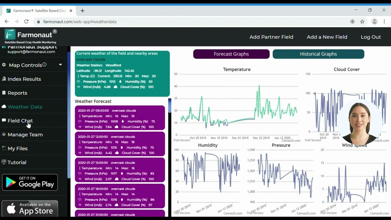
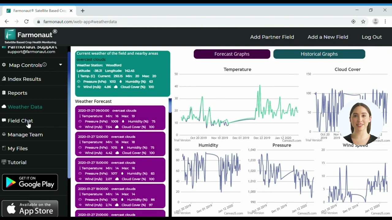
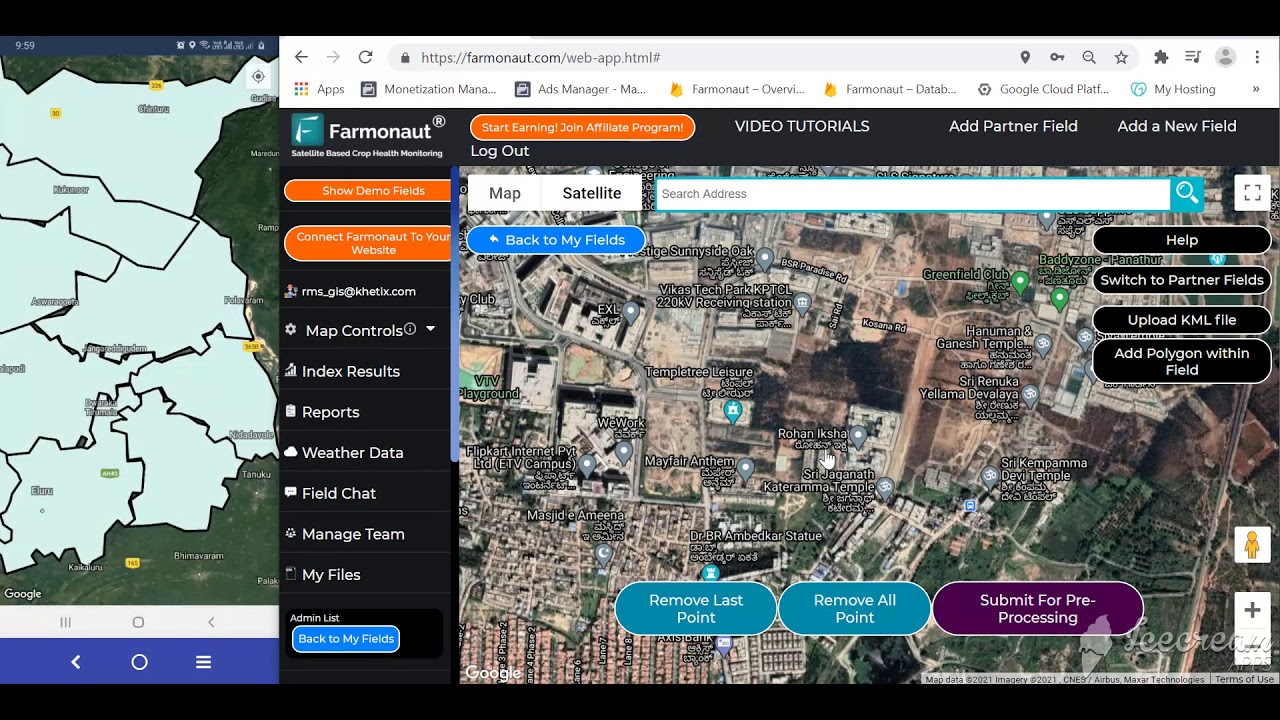
Farmonaut’s approach to that pipeline runs through a developer-facing satellite and weather API, documented at the API developer docs, so a farm’s own FMS or a third-party drone platform can pull satellite layers alongside anything uploaded from a drone flight instead of juggling two logins. The video above walks through the web interface end to end.

Where drone data earns its keep is the advisory layer on top of it — turning an NDVI map into a plain-language recommendation instead of another map to interpret, as shown above.
Drone Coverage & First-Year Cost Calculator
The two real questions before buying or contracting a mapping drone are how many drone-days it takes to cover the farm, and what that costs in the first year once FAA compliance is included. Enter your own numbers below.
Run your own numbers
Assumptions: the $215 one-time compliance figure is the Part 107 test fee ($175), drone registration ($5) and Remote ID (about $35) reported by University of Maryland Extension, and applies only if you select “flying it myself.” It excludes drone purchase price, insurance, image-processing software fees, and any Part 137 costs for spray drones. The 550-acre-a-day placeholder in the coverage field is the rate a contractor-flown LiDAR survey achieved on Irish Signpost farms, reported by the Irish Farmers Journal — a reasonable starting point for a contracted mapping flight, not a guarantee for every aircraft or field shape.
Drones on Irish Farms: Productivity, Sustainability and ROI
Ireland had 133,174 farms in 2023, down 4.6% from 139,595 in 2013, with a mean size of 34.7 hectares and a median of just 21.3 hectares, according to the Central Statistics Office’s Farm Structure Survey 2023, released 17 December 2024. More than half — 56.1%, or 74,666 farms — are specialist beef holdings. That fragmentation is the backdrop for the “impact of drones on Ireland’s farm productivity” question: a single flight rarely covers one contiguous block, so the economics of drone survey work in Ireland hinge on covering several parcels, or several neighbouring farms, per outing.
The clearest published example of what that looks like in practice comes from Teagasc’s Signpost Programme. On its “Footprint Farms,” contractor Bob Foley of Engineers with Drones used LiDAR and multispectral imaging to survey up to 550 acres in a day — coverage he told the Irish Farmers Journal in February 2023 “could not be achieved if a plane was used instead.” Two Footprint Farms had been surveyed by that date, with the rest scheduled by the end of the year; the imagery feeds Teagasc’s carbon and biodiversity accounting, mapping hedgerows and woody habitat alongside crop and grassland layers. Teagasc’s own material on the technology (Spatial Analysis unit, 2020) describes multispectral sensors detecting disease and stress in a field, and thermal sensors reading soil moisture below the surface — the qualitative case for “benefits of drones in Irish agriculture” that the Signpost coverage rate turns into a quantified one.
Ireland’s organic sector is the fastest-growing segment where drone imagery is being pitched for surveillance and compliance support: the CSO counted 4,168 organic farms in 2023, up from 1,686 in 2020 — a 147.2% increase — covering roughly 180,000 hectares of utilised agricultural area against about 75,000 hectares in 2020, or 3.9% of the state’s total utilised agricultural area. Certifiers still require on-the-ground inspection, but a repeat aerial survey gives an organic operation a dated, geolocated record of buffer strips, non-treated zones and land-use continuity between inspection visits — the practical version of “drones for organic farming surveillance in Ireland.”
On direct ROI: no Irish government body has yet published a national drone-specific return-on-investment figure, so treat any single “X% ROI” claim you find elsewhere as a vendor estimate rather than an official statistic. What is verifiable is the input side of that calculation — coverage rate, day rate and compliance cost — which is exactly what the calculator above works out from your own numbers. On funding, Ireland’s Targeted Agricultural Modernisation Scheme (TAMS) and the ACRES agri-environment scheme periodically list eligible equipment and grant rates that change between tranches; confirm current eligibility with the Department of Agriculture, Food and the Marine before assuming a piece of kit qualifies.
Two Farmonaut modules map onto that reporting need: carbon footprinting for the hedgerow and emissions accounting Teagasc’s Signpost farms are tracking, and product traceability for buyers who want a dated record behind an organic or premium claim. On the finance side, lenders and insurers increasingly ask for exactly this kind of geolocated record before extending crop loan and insurance terms.
How Ireland Compares: EU Farm Digitalisation
Eurostat’s farm-structure news release, published 24 July 2026 and covering 2023 survey data, puts EU-wide context around the Irish figures above. Across the EU, 43% of farms reported internet access in 2023, with Denmark, Germany, Slovakia, Latvia, Czechia and Austria all above 90%. About 18% of farms with utilised agricultural area applied some precision-farming technology — a category covering variable-rate application, precision crop and soil monitoring, and robotics for plant protection — and that 18% of farms managed roughly 44% of all EU farmland, meaning adoption skews toward the largest holdings, mirroring the USDA pattern above. Only about 11% of EU farms used a digital farm management information system at all, though France’s rate was close to 60%, the highest reported; around 7% of EU farms used autonomous robotic technology.
The country range behind that 18% average is wide: Luxembourg, Finland and Estonia all reported precision-farming adoption above 75%, while Cyprus sat at about 1%, and Greece and Romania both fell in the 10–15% band. Ireland’s own country-level rate was not broken out in this particular release. What is on record is that the CSO added a first-ever internet-access and electronic-farm-management-tools question set to the 2023 Farm Structure Survey questionnaire, confirmed in the Irish Farmers Journal’s preview of the survey in June 2023 — so a directly comparable Irish figure should surface in a future release; check the CSO Farm Structure Survey page for the update.
One Platform for Satellite, Drone and Compliance Data
Farmonaut’s platform is built to sit under the pipeline described above rather than replace any one piece of it: satellite monitoring for the whole-farm layer, an AI advisory for turning imagery into a recommendation, and modules built around the paperwork Irish, EU and US compliance and export buyers ask for.
- Satellite-based monitoring of crop growth, soil conditions and field stress
- An AI advisory layer that turns satellite and drone-derived layers into a written recommendation rather than another map to read
- Large-scale farm management tools for operations running multiple fields or multiple client farms from one dashboard
- Fleet management for coordinating machinery and contractor visits around flight or spray windows
- Carbon footprinting and product traceability modules for the sustainability and export-market reporting referenced above
- Developer access via the satellite and weather API and its developer docs, for teams building their own farm drone data platform on top


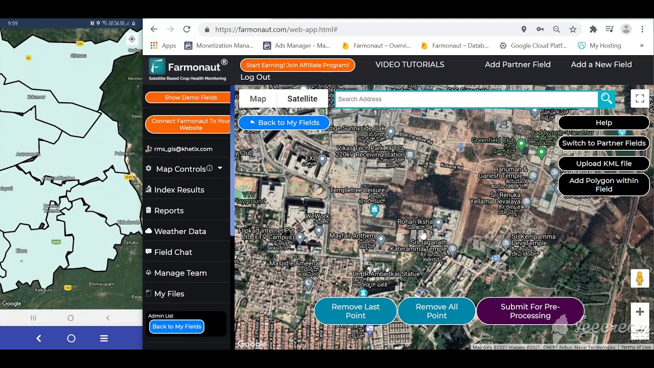
The three videos above cover, in order: managing a large-scale operation from the Agro Admin dashboard, connecting a farm to satellite monitoring over WhatsApp in about two minutes, and mapping a large area end to end.



Download Farmonaut’s app suite to keep satellite and drone-sourced farm data on hand wherever you are.
Frequently Asked Questions
It’s collecting information from every source on a farm — soil, weather, machinery, satellite and drone — into one system, so it can drive a decision rather than sit in a separate app. See the source comparison table above for what each input is actually good at.
Start with a mapping or multispectral drone under 55 lb, which keeps you inside FAA Part 107 with no Part 137 requirement. If you’re unsure the workflow pays off, hire a contractor for a season first — the 550-acres-a-day benchmark from Ireland’s Teagasc Signpost programme is a realistic reference point for what a contracted flight can cover.
Six main categories feed most systems: satellite imagery, drone imagery, soil sensors, yield monitors and machinery telemetry, weather stations, and manually logged records. Each has a different spatial resolution and refresh interval, detailed in the comparison table in the sources section above.
Through a five-step pipeline — capture, transfer, analysis, prescription and record-keeping — usually via an API or direct upload into the FMS, as shown in the integration section and tutorial video above.
No Irish government body has published a national drone ROI figure, so calculate your own from coverage rate, day rate and compliance cost using the calculator above. TAMS and ACRES grant terms for eligible precision-farming equipment change between tranches, so confirm current eligibility with the Department of Agriculture, Food and the Marine before buying.
They support it rather than replace it: repeat aerial imagery gives an organic operation a dated, geolocated record of buffer strips and land use between certifier inspections. Ireland’s organic farm count rose from 1,686 in 2020 to 4,168 in 2023, per the CSO, which is expanding demand for exactly this kind of record-keeping.
What Would Change This Picture
Three things would move the adoption numbers above, and each has a specific place to check for movement:
- Connectivity. Eurostat’s 43% EU farm internet-access figure for 2023 caps how many farms can even receive a cloud-processed drone or satellite layer in the field; watch Eurostat’s farm-structure updates for the next reading.
- Ireland’s own technology cross-tab. The CSO collected internet-access and electronic-farm-management-tool answers for the first time in the 2023 survey; the published cross-tabulation will give Ireland a country-specific adoption rate to replace the EU average used here.
- US regulatory change. Any FAA move on beyond-visual-line-of-sight operation for Part 107 would cut the labour cost behind the coverage-rate assumption in the calculator above, since one pilot could then run more than one aircraft at once.
None of that changes the underlying method: match the data source to the question you’re asking — satellite for a trend, drone for a two-metre problem satellites can’t resolve — price the labour and compliance side honestly, and keep the record in one system so it counts toward compliance and lending as well as this season’s spray plan.






The Short Version
Farm data management works when every source above lands in one system: satellite for the whole-farm baseline, drones for the zone-level problem satellites can’t resolve, sensors and telemetry for what happens at ground level and inside the machine. In the U.S., that combination still reaches under a third of farms; in Ireland, the fragmented, 34.7-hectare average holding makes shared or contracted flights the more common starting point than solo drone ownership. Whichever side of that line your farm sits on, the figures and the calculator above are the place to start pricing it out — not a vendor’s ROI slide.

 Doodlakine
 Nale Network
 Exurbia Geospatial
 FieldZero
 Indico Company
 Kubota
 FFBS
FFBS Jontra
 Kalustyan
 Tucor
Tucor Geno
Geno Hayleys Agriculture
 Linx Agritech
 Adinet
