

Reviewed September 2026 against USDA Economic Research Service, the FAA, and Frontiers in Agronomy.
Try it: Drone Spray Cost & Labor-Savings Calculator →
Drone farming is the use of unmanned aerial vehicles — carrying cameras, multispectral sensors, or spray tanks — to scout, map, and treat cropland from the air instead of on foot or by manned aircraft. In the United States it is a real market already: the US agricultural drone market was valued at $506.3 million in 2024, and spray-drone operators are running commercial jobs across the Corn Belt for $12–$17 per acre. This article covers what the technology actually does, what it costs, where the AI genuinely adds value versus where the marketing gets ahead of the data, and how to size a drone-spraying decision for your own acreage.
How Big Is Drone Farming, Really?
The US agricultural drone market was worth $506.3 million in 2024, according to Market Research Future, and is projected by Research and Markets to reach $1.76 billion by 2030. That is roughly 3.5x growth in six years — a real trajectory, not a marketing number, though both figures are market-research estimates rather than government statistics, so treat them as directional rather than exact.
Adoption on the ground still lags the market-value story. The most recent official figures from the USDA Economic Research Service put aerial-imagery adoption at 7.0% of corn acres (2016), 9.8% of soybean acres (2018), and 3.5% of winter wheat acres (2016–2019). Those numbers predate the current wave of AI-guided spraying, and the USDA Census of Agriculture — the source for a real national update — is only released every five years, with the next edition due in 2027. Interim, state-level reads are available from the Iowa State University Extension’s Annual Agricultural Machinery Survey; one such estimate for Iowa put drone-technology adoption at 22% of farmers for the 2024–2025 period. There is no current published US national adoption rate for commercial agricultural drones — anyone citing one for the present moment is estimating, not reporting.
Drones in Agriculture: What Changed vs. Ground Scouting
Before drones, crop scouting meant walking or driving field transects — slow, and it samples only the path taken. A drone in agriculture use case instead covers the whole field from above in one flight, at a resolution fine enough to see plant-level stress before it shows up in a windshield survey.
- Full-field coverage, not sampled transects: a single flight images every row, not just the rows a scout happened to walk.
- Objective, timestamped data: imagery becomes a comparable record across weeks, rather than a subjective field note.
- Earlier detection: multispectral bands pick up plant stress before visible symptoms — see the disease-detection figures below.
- Faster turnaround: a scouted field can be flagged and mapped same-day, instead of waiting for the next walk-through.

Integrating Drones With AI: What’s Actually New
Integrating drones with AI for farming means pairing the aerial sensor with a model that turns pixels into a decision — not just a prettier map. The measurable gains, from a 2025 synthesis published in Frontiers in Agronomy, are specific enough to plan around:
- Yield response: UAV-NDVI-guided irrigation and nitrogen management produced a 37.2% maize yield increase in the study’s trial conditions.
- Disease detection: AI models trained on drone imagery reached 95% detection accuracy for fungal infections before visible symptoms emerged.
- Irrigation savings: fusing UAV imagery with satellite data and machine learning cut irrigation costs by 20–25%.
- Yield prediction accuracy: a satellite remote-sensing model for wheat grain yield reached an R² of 0.83 — a strong fit, though it is one study’s result, not a universal constant.
These are peer-reviewed trial results, not guaranteed farm outcomes — soil type, cultivar, and season will move the number in either direction. Treat them as the ceiling AI-guided management is currently demonstrating in controlled studies, and benchmark your own field against them rather than assuming you’ll land exactly on 37.2%.
AI Obstacle Avoidance in Drone Farming
AI obstacle avoidance is the sensor-and-software layer — typically LiDAR, radar, or vision-based cameras — that lets a spray or mapping drone detect power lines, trees, irrigation pivots, and terrain changes and adjust its flight path without a human pushing the stick every second. It’s a required feature on nearly every commercial ag-spray platform sold today, because farm fields carry more low-altitude obstacles (center-pivot towers, grain bins, tree lines) than open-field imagery flights.
Here’s the honest gap: there is no published, standardized field data on detection range, false-positive rate, or comparative safety outcomes for AI obstacle-avoidance systems versus manual visual-line-of-sight piloting. Manufacturer spec sheets quote sensor range in isolation, but no government body or peer-reviewed study in the current research base benchmarks obstacle avoidance against manual piloting in real farm conditions. If this decision matters for your operation — say, you’re choosing between two spray-drone platforms — the practical path is to request incident/near-miss logs directly from the manufacturer or your FAA Part 137 operator, and to ask your state’s Cooperative Extension drone program (many, including Iowa State’s, run field demonstrations) whether they’ve tested the specific model.
Operators worried about crashes or liability can look into insurance cover for farm drones before flying near obstacles.

Seven AI Drone Applications Worth Knowing
These are the seven places AI is doing real work in AI drone systems for farming today, ranked by how directly each one changes an input decision.
1. AI-Driven Multispectral Imaging and Analysis
- How it works: multispectral and hyperspectral cameras capture reflectance beyond visible light, exposing soil, moisture, and crop-health patterns invisible to the eye.
- What the AI adds: pattern recognition flags stress zones automatically instead of requiring a human to scan every frame.
- Evidence: this is the imaging layer behind the 95% fungal-detection-before-symptoms figure cited above.

2. Automated Pest and Disease Detection
- How it works: onboard or cloud-based image recognition scans canopy imagery for visual signatures correlated with pest pressure or fungal disease.
- Benefit: targeted intervention instead of blanket spraying — this is the mechanism behind the 30–50% pesticide-use reduction figure covered under Costs below.
3. AI-Powered Variable-Rate Spraying
- How it works: the drone adjusts spray output in real time based on a mapped canopy or soil layer, rather than applying a flat rate across the field.
- Documented reduction: precision drone application is associated with a 30–50% reduction in pesticide use, per a 2024–2025 research synthesis.

4. AI-Enhanced Flight Path Optimization
- How it works: onboard planning software generates coverage routes that minimize overlap and dead legs, extending effective battery life per acre covered.
- Benefit: fewer flights per job, faster turnaround on large acreage, and — combined with obstacle avoidance above — the routing that makes autonomous operation viable near pivots and tree lines.
5. Real-Time Crop Health Monitoring and Alerts
- How it works: imagery and derived indices push to a mobile app or dashboard so a grower can act the same day rather than waiting on a report.
- Benefit: faster response on irrigation timing, nutrient gaps, or emerging pest pressure.

6. Integrated Fleet and Resource Management
- How it works: software coordinates multiple drones and ground equipment — spray schedules, battery swaps, refill logistics — across a large operation.
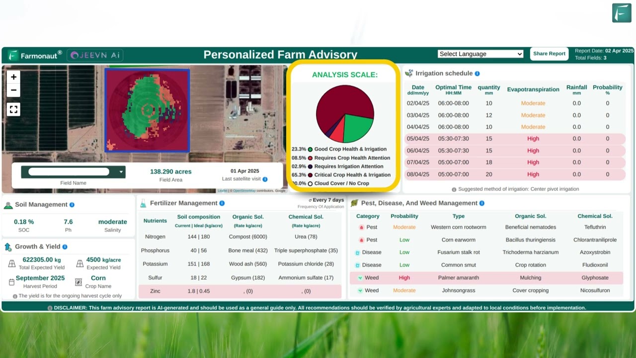
- Where to look: Farmonaut’s Fleet Management tracks vehicle usage and logistics for agribusinesses running mixed drone-and-ground fleets.
7. Traceability and Compliance Recordkeeping
- How it works: drone-gathered field data feeds a digital record of inputs applied and conditions observed, supporting supply-chain verification.
- Where to look: Farmonaut Product Traceability for farm-to-market documentation.
Comparison Table: Where Each Innovation Pays Off
| Innovation | Documented Metric | Source & Period |
|---|---|---|
| UAV-NDVI-guided irrigation + nitrogen | +37.2% maize yield | Frontiers in Agronomy, 2025 |
| AI disease detection (multispectral) | 95% accuracy pre-symptom | Frontiers in Agronomy, 2025 |
| UAV-satellite-ML irrigation fusion | 20–25% cost reduction | Frontiers in Agronomy, 2025 |
| Precision variable-rate spraying | 30–50% less pesticide used | Research synthesis, 2024–2025 |
| Drone spraying vs. manual labor | 75–90% labor cost reduction | Ag Drone Directory, 2025 |
| Satellite yield prediction (wheat) | R² = 0.83 | Frontiers in Agronomy, 2025 |
Drone Farming Costs: What US Operators Actually Pay
Cost is where drone-for-agriculture searches usually stall out on vague answers. Here is what Iowa State University Extension and industry benchmarking actually document for 2025:
- Row crops (Corn Belt): $12–$17 per acre for drone spray application.
- Orchard and vineyard: $18–$40 per acre — higher because of canopy density and slower pass speeds.
- Fungicide ROI on corn: Beck’s Practical Farm Research measured a $27.26 per acre return from fungicide applied via drone spray in 2025.
- Labor cost reduction: drone spraying cuts labor cost by 75–90% versus manual application methods.
- Subsidy offset: USDA’s EQIP program can cover up to 75% of precision-agriculture technology costs for eligible producers, per Penn State Extension’s guidance on EQIP and drone adoption — check current EQIP ranking criteria and funding pools with your local USDA Service Center, since both change by fiscal year.
None of these figures are indexed for inflation or fuel cost beyond 2025 — Iowa State Extension updates its ag drone pricing guidance periodically, so confirm the current range against the Ag Drone Directory pricing page before budgeting a season.
Drone Spray Cost & Labor-Savings Calculator
Assumes drone cost at the low end for row crops ($12/acre) or orchard/vineyard ($18/acre); adjust by editing the crop-type range in your own quote. Excludes equipment purchase, insurance, FAA Part 137 certification, and per-job mobilization fees. Labor-cost-reduction range (75-90%) is from Ag Drone Directory’s 2025 industry analysis and is shown for comparison, not guaranteed for your operation.
FAA Rules for Agricultural Drone Spraying
Commercial agricultural spraying by drone in the US operates under FAA Part 137, the same rule that governs manned agricultural aircraft, extended to cover unmanned applicators. As of September 2025, the FAA had issued 1,710 Part 137 agricultural drone operator certificates, per figures cited in industry reporting from EAVision's coverage of FAA Part 137 rules. That count will keep changing as more operators certify — the FAA does not publish a live public counter, so treat any figure you see, including this one, as a snapshot and confirm the current total directly through your regional FAA Flight Standards District Office before assuming certification volume in your state.
Separately, the FAA has been developing a Part 108 framework intended to govern autonomous and beyond-visual-line-of-sight drone operations — this would matter directly for autonomous ag-spray flights near obstacles. No certified-operator counts or finalized timeline for Part 108 exist in the current public record; if autonomous operation authority is relevant to a purchase decision, check the FAA's rulemaking docket directly rather than relying on a projected date.
Sustainable Agriculture Drone Use
A sustainable agriculture drone program is really the variable-rate and early-detection layer applied with an environmental lens: the same 30–50% pesticide-use reduction that saves money also cuts chemical runoff into waterways, and the 20–25% irrigation-cost reduction from UAV-satellite-ML fusion translates directly into reduced water draw. Precision application targets only the zones a multispectral scan flags as stressed, rather than treating a whole field uniformly — the mechanism is identical to innovation #3 above, applied as a conservation practice rather than a cost-cutting one.
Forestry and Land Management Applications
The same imaging and AI-detection stack extends past row crops into forestry and land management:
- Forest density and tree health mapping: canopy-level imagery tracks growth, sapling survival, and pest or disease spread across large tracts.
- Illegal logging detection: autonomous survey flights flag encroachment or unauthorized cutting in remote or hard-to-patrol areas.
- Post-wildfire assessment: burn-severity mapping helps prioritize reforestation zones.
- Carbon monitoring: aerial and satellite data support carbon footprint tracking for compliance and voluntary-market reporting.

Agriculture Drone for Rent
Given the $12–$40 per-acre spray range and the added cost of FAA Part 137 certification, many US operations use agriculture drone for rent services rather than buying outright — a full breakdown of pricing structures and regional rates is covered in that dedicated guide. In brief, renting shifts fixed equipment and maintenance costs into a variable per-job or per-season fee, and many services bundle a licensed Part 137 pilot with the machine, which sidesteps the certification requirement entirely for the renting farm.



Choosing a Drone for Agriculture Purpose
Match the platform to the job before comparing brands:
- Farm size and terrain: larger acreage needs longer flight time and bigger payload capacity; hilly or forested land needs strong obstacle-avoidance sensors (see above) and altitude adaptability.
- Crop and input needs: spray-tank drones suit row crops, orchards, and vineyards; imaging-only drones suit scouting-focused operations that contract out spraying.
- Sensor package: multispectral or hyperspectral cameras are what enable the disease-detection and stress-mapping figures cited earlier — a standard RGB camera cannot replicate them.
- Certification path: spraying requires an FAA Part 137 certificate for the operator, not just the airframe — factor this into the buy-vs-rent decision.
- Subsidy eligibility: check whether the platform and your operation qualify for EQIP cost-share (up to 75% of technology cost) before finalizing a purchase.
Exact purchase prices for named commercial platforms (e.g., DJI Agras-class spray drones) are not included here because dealer pricing fluctuates by region and configuration, and no standardized USDA or government price reference exists — get a current quote from a licensed dealer or Part 137 operator in your state rather than relying on a published list price.
Where Farmonaut Fits: Satellite Data Alongside Drones
Farmonaut does not manufacture or sell drones or spray equipment. What it provides is the satellite-based layer that complements drone data — useful because satellite imagery covers a whole operation continuously, while drone flights are scheduled, job-by-job events.
- Real-time crop health monitoring: NDVI, soil moisture, and vegetation-health tracking that flags where a drone flight is worth scheduling.
- Jeevn AI advisory: field-, crop-, and weather-specific recommendations generated from the same data stream.
- Blockchain traceability: farm-to-market verification for food, textile, and corporate supply chains — Farmonaut Product Traceability.
- Fleet and resource management: Farmonaut Fleet Management for tracking vehicle usage and logistics.
- Carbon footprinting: emissions tracking toward sustainability targets — Farmonaut's Carbon Footprinting solution.
- Large-scale farm management: the Agro Admin App for multi-field monitoring and compliance across large operations.
- Crop loans and insurance: satellite-based verification via Farmonaut Crop Loan & Insurance.
The platform runs on Android, iOS, and web. Developers building their own tools can pull real-time satellite and weather data directly through the API, documented at the Developer Docs.
Frequently Asked Questions
What is drone farming?
Drone farming is the use of unmanned aerial vehicles for crop scouting, multispectral imaging, and spray application. In the US it operates commercially under FAA Part 137 for spraying, with 1,710 certified operators as of September 2025.
What are drone applications in agriculture beyond spraying?
Multispectral crop-health mapping, pest and disease detection, variable-rate input application, forestry and land-management surveys, post-wildfire burn assessment, and fleet coordination across large operations.
How much does drone spraying cost per acre?
Iowa State University Extension documents $12–$17 per acre for row crops in the Corn Belt and $18–$40 per acre for orchard and vineyard applications, as of 2025.
What does AI obstacle avoidance do on a farming drone?
It uses LiDAR, radar, or vision sensors to detect obstacles — power lines, pivots, trees — and adjust flight path automatically. No standardized field data yet compares its detection performance to manual visual-line-of-sight piloting; ask the manufacturer or your Part 137 operator for incident logs on a specific platform.
Are agriculture drones for rent available in the US?
Yes — rental and contract-spray services are active in the Corn Belt and beyond, often bundling a certified Part 137 pilot with the equipment. See the dedicated agriculture drone for rent guide for pricing structures.
Does Farmonaut sell drones?
No. Farmonaut provides satellite-based farm management data — crop health, soil moisture, and weather analytics — that complements drone-collected data, via Android, iOS, Web, and API.
What subsidies exist for drone adoption?
USDA's EQIP program can cover up to 75% of precision-agriculture technology costs for eligible producers, per Penn State Extension guidance. Eligibility and funding pools change by fiscal year — confirm current terms with your local USDA Service Center.
Conclusion
Drone farming in the US is past the hype phase: a $506.3 million market in 2024, documented per-acre spray costs, a 1,710-strong certified operator base, and peer-reviewed yield and cost figures from Frontiers in Agronomy give this technology a real evidence base. The gaps that remain — national adoption rate, obstacle-avoidance benchmarking, Part 108 timelines — are gaps because no one has published the data yet, not because the technology doesn't work. Use the sources above, run your own numbers through the calculator, and confirm anything time-sensitive against the USDA, FAA, or Extension link before you budget a season around it.

 Contec Global
 ASQI
ASQI Teledarbas
 Wild Oak Farm
 SFX
SFX BACF Africa
 Doodlakine
 Exurbia Geospatial
 FieldZero
 Indico Company
 Kubota
 FFBS
FFBS Jontra
 Tucor
Tucor
