

Reviewed August 2026 against USDA Economic Research Service adoption charts, GM Insights market data, and peer-reviewed irrigation-sensing research (PMC/NIH).
Try it: Run your own numbers →
Crop monitoring in agriculture using IoT means networking soil sensors, weather stations, drones, and satellite feeds so a grower sees field conditions on a dashboard instead of walking every row. On large-scale US crop farms, USDA’s Economic Research Service found 70% already use guidance autosteering and 68% use yield monitors or yield maps as of 2023 — this is not an emerging technology on the biggest farms, it is baseline equipment. The gap is elsewhere: mid-size and small operations, where adoption drops sharply and the tools remain unfamiliar.
This article covers what IoT-based crop monitoring actually is, where automation using IoT has and hasn’t caught on, what the sensors and platforms cost to run, and how to size a water-savings case for your own acreage — with a calculator at the end built on the ranges cited below, not generic assumptions.
Table of Contents
- What “IoT” Means in Agriculture
- Adoption Rates: Who Actually Uses This
- Agriculture Automation Using IoT
- Crop Monitoring Tools Compared
- IoT Agriculture Sensors: What They Measure
- Market Size & What’s Driving Growth
- How to Grow and Sell Wheat Profitably
- Farmonaut’s Satellite-Based Approach
- Water Savings Calculator
- Barriers to Adoption
- FAQs
- Get Started
- Try it: Run your own numbers
What “IoT” Means in Agriculture
IoT (Internet of Things) in farming is a network of connected devices — soil probes, weather stations, machine-mounted GPS receivers, drone cameras, satellite feeds — that collect field data and transmit it over a network (cellular, LoRaWAN, or satellite uplink) to software that a person can act on. The three layers are consistent across every implementation:
- Sensing layer: soil moisture/temperature probes, canopy or multispectral cameras, weather stations, GPS on machinery
- Transmission layer: cellular (4G/5G), LoRaWAN for low-power/long-range soil sensors, or satellite where cell coverage doesn’t reach the field
- Decision layer: dashboards, alerts, and — increasingly — automated triggers (irrigation valves that open themselves, sprayers that adjust rate on the move)
The distinction that matters for a purchase decision is between ground-based IoT (physical sensors installed in a specific field, giving continuous point-in-time data but requiring hardware, installation, and maintenance) and remote sensing (drones or satellites, giving broad coverage with no field hardware but less temporal density unless you pay for frequent satellite passes or repeat drone flights). Most working farms combine both rather than choosing one.
Adoption Rates: Who Actually Uses IoT-Based Crop Monitoring
The figures below come from USDA’s Economic Research Service (ERS) Charts of Note, based on 2023 survey data, and they cut against a common assumption — that “smart farming” is niche. On large-scale crop farms it is standard practice; on smaller operations it barely registers:
| Technology | Large-scale crop farms | Midsize crop farms |
|---|---|---|
| Guidance autosteering systems | 70% | 52% |
| Yield monitors / yield maps / soil maps | 68% | Not broken out in ERS chart |
| Variable rate technology (VRT) | 45% | Not broken out in ERS chart |
| Drones (on crop-producing family farms) | 12% | Lower — increases with farm size per USDA |
Source: USDA Economic Research Service, Charts of Note (2023). USDA also reports that precision agriculture technologies of some kind now cover 60% of US planted acreage as of 2025, per its most recent ERS release. That 60% figure is an acreage-weighted number, not a farm-count number — it’s driven by the fact that large operations, who’ve adopted fastest, farm a disproportionate share of total acres.
Drone adoption is the clearest illustration of the size gap: Capital Press’s reporting on USDA data puts drone use at 12% on large-scale, crop-producing family farms in 2023, and confirms the general pattern that every precision technology category rises with farm size. If you farm under a few hundred acres, the honest read of this data is that you’re not behind some invisible majority — you’re in the majority. The tools that pay off first at small scale tend to be the lowest-fixed-cost ones: soil moisture sensors and satellite-based monitoring that need no field hardware, rather than autosteer systems that require a compatible tractor fleet.
Refresh path: ERS updates its Charts of Note on a rolling basis — check the live page at ers.usda.gov/data-products/charts-of-note for whichever year’s survey is current when you’re reading this. For a finer cut by state, crop, or farm size than the published charts show, USDA’s NASS QuickStats tool at quickstats.nass.usda.gov lets you build a custom query against the underlying survey data.
Agriculture Automation Using IoT: From Fieldwork to Fleet Management
Automation using IoT sensors and autonomous machinery converts routine fieldwork — planting, irrigating, spraying, harvesting — into software-triggered actions instead of manually scheduled ones. The mature use cases:
IoT-Enabled Tractors & Autonomous Machinery
Equipped with GPS, sensors, and onboard software, modern agricultural machines handle planting, fertilizing, and harvesting at pre-set precision. This is the single most widely adopted automation category in the US — 70% of large-scale crop farms already run guidance autosteering, per the ERS data above. Benefit: reduced labor hours and lower fuel use through route optimization, since overlapping passes are largely eliminated.

Automated Irrigation Systems
Soil-embedded IoT sensors track moisture and temperature; when a threshold is hit, valves trigger automatically. Peer-reviewed research aggregated on PMC/NIH documents water savings in the range of 30% from soil-moisture-sensor-based irrigation scheduling compared with calendar-based watering — see the PMC study on IoT-based irrigation management for the underlying methodology. That 30% figure is a documented study range, not a universal guarantee — actual savings on a given field depend on soil type, current irrigation practice, and how much the calendar-based baseline was already over-watering.
Smart, Variable-Rate Fertilizer Application
Variable rate technology (VRT) applies nutrients at a rate that changes across the field rather than uniformly. USDA ERS puts VRT adoption at 45% on large-scale crop farms in 2023 — lower than autosteer or yield mapping, reflecting that VRT requires both the equipment and a yield/soil map to act on, so it tends to follow rather than lead other precision investments on a given farm.
Crop Health Drones
Autonomous drones with multispectral cameras flag plant stress and, on some platforms, perform targeted spraying. At 12% adoption on large-scale family farms in 2023, drones remain the least-adopted automation category in the USDA data — likely reflecting per-flight cost and the regulatory overhead of operating UAS compared with fixed ground sensors or satellite subscriptions.
- ✔ Autonomous operations reduce repetitive manual labor
- 📊 GIS & fleet tracking ensures optimal equipment use and reduced downtime
- ♻ Automated reporting supports compliance and audit trails



Crop Monitoring Tools Compared: Sensors, Drones, and Satellites
“Crop monitoring in agriculture” covers three distinct data-collection methods, and the right one depends on field size, budget, and how often you need updated data:
| Method | Coverage per unit | Update frequency | Field hardware required | Best fit |
|---|---|---|---|---|
| Ground IoT sensors (soil moisture, temp, EC) | Single point or small zone | Continuous | Yes — probe, gateway, power | Precision irrigation on a known problem zone |
| Drones / UAVs | Whole field, per flight | Per flight (on demand) | No fixed hardware; requires operator/pilot | Scouting for pest/disease hotspots between visits |
| Satellite monitoring | Whole farm or region | Per satellite revisit (varies by provider/constellation) | None | Large or multi-field operations, remote land with no connectivity |
IoT Monitoring Tools & Techniques
- Soil Sensors: Continuously track moisture, temperature, nutrient levels, and electrical conductivity — used to pinpoint water stress or fertility hotspots
- Aerial Drones & UAVs: Multispectral cameras scan fields to expose crop stress and pest infestations not visible to the eye
- Weather Stations: Track temperature, humidity, rainfall, and wind to forecast growing conditions
- Remote Satellite Sensing: Platforms like Farmonaut provide satellite-based field coverage for large-scale, continuous monitoring with no on-field installation

From Data to Decisions
Yield monitoring and mapping systems — now on 68% of large-scale US crop farms — feed the analytics layer that everything else depends on: without a yield map, variable-rate application has nothing to target. According to EOS’s analysis of yield monitoring and mapping, integrated crop monitoring and IoT systems are documented to reduce pesticide use by around 20% by replacing calendar-based spraying with detection-triggered spraying — applying product only where and when field data shows a need, rather than on a fixed schedule regardless of actual pest pressure.

IoT Agriculture Sensors: What They Actually Measure
“Agricultural IoT sensors” is a broad label. In practice, deployments fall into four measurement categories, each solving a different problem:
- Soil sensors — volumetric water content, temperature, and electrical conductivity (a proxy for salinity/nutrient concentration). Installed at root depth, wired or LoRaWAN-connected to a field gateway.
- Canopy/plant sensors — leaf wetness, canopy temperature, and in some systems chlorophyll fluorescence, used to catch drought or disease stress before it’s visible to the eye.
- Weather stations — rainfall, wind speed, humidity, and solar radiation, feeding both irrigation scheduling and spray-timing decisions (wind speed thresholds for drift, for example).
- Machine/asset sensors — GPS and telematics on tractors, sprayers, and irrigation pivots, the data layer behind fleet management and autosteer.
For plant automation specifically — automated response to a sensor reading, not just logging it — the sensor and the actuator have to be on the same network with a defined trigger threshold (e.g., “open valve at 30% volumetric water content”). Systems that only log data to a dashboard without a wired actuator are monitoring tools, not automation; the two get marketed under the same “IoT” umbrella but solve different problems and are priced very differently — sensor-only kits are far cheaper than a sensor-plus-actuator retrofit on existing irrigation infrastructure.
Market Size & What’s Driving Growth
The North America crop monitoring market was valued at $1.3 billion in 2025, with a projected compound annual growth rate of 12.8% from 2026 through 2035, according to GM Insights’ industry analysis. That growth rate, if it holds, implies steady expansion in satellite and sensor-based monitoring spend specifically — distinct from the broader “agricultural IoT” category, which also includes autosteer and machine telematics.
Refresh path: GM Insights and comparable market-research firms revise these projections annually as new baseline-year data comes in — treat any multi-year CAGR figure as a forecast tied to its publication date, not a locked-in outcome, and check the source report directly for the current revision before citing it in a business case.
How to Grow and Sell Wheat Profitably
Profitable wheat production comes down to controlling cost per bushel and timing the sale, not just maximizing yield. IoT and monitoring tools affect the cost side directly; the marketing side is a separate discipline that no sensor replaces.
The Production Side: Where Monitoring Cuts Cost
- Variable-rate seeding and fertilizer using yield-map data (68% of large farms already have the yield-mapping layer per USDA ERS) avoids paying for inputs on parts of the field that can’t use them.
- Soil moisture monitoring at planting and during grain fill helps time irrigation (where wheat is irrigated) using the same sensor-driven approach documented to save around 30% of water versus calendar scheduling, per the PMC research on IoT irrigation cited above.
- Disease scouting via drone or satellite imagery catches stripe rust or Fusarium head blight early enough that a single well-timed fungicide pass replaces a reactive, more expensive one — consistent with the ~20% pesticide-use reduction documented by EOS for monitoring-driven spray decisions.
The Selling Side: Where the Money Is Actually Made or Lost
Wheat is a commodity crop priced on Chicago Board of Trade futures, and the spread between harvest-time cash price and a forward-contracted or stored-and-later-sold price is frequently larger than any single agronomic input decision. This article’s data doesn’t include current wheat futures pricing or basis levels — those move daily and any figure printed here would be stale within a week. For a current price to plan a sale around, check CBOT wheat futures directly or your local elevator’s posted basis, and cross-reference USDA NASS QuickStats (quickstats.nass.usda.gov) for regional average cash prices by state and month.
The durable checklist for a profitable wheat marketing decision doesn’t expire with the price:
- Know your breakeven cost per bushel — total input, land, and operating cost divided by expected yield, recalculated for the actual season, not last year’s numbers.
- Track basis, not just futures — the local cash price relative to the futures contract; a strong futures price with wide negative basis at your elevator can still be a poor sale.
- Use forward contracts to lock in a margin above breakeven once one is available, rather than waiting for a price peak that may not come.
- Verify grain quality specs (protein content, test weight, moisture) before delivery — discounts for off-spec wheat routinely erase a marketing plan’s assumed margin.
- Reassess storage cost versus carry — if the forward market pays more for later delivery than your on-farm or commercial storage costs, store; if not, sell at harvest.
None of these five steps require IoT hardware — they’re a marketing discipline. What IoT and satellite monitoring change is the cost side of the breakeven calculation in step one, by lowering input waste through the variable-rate and detection-triggered approaches above.

Farmonaut: Satellite-Driven Crop Monitoring Without Field Hardware
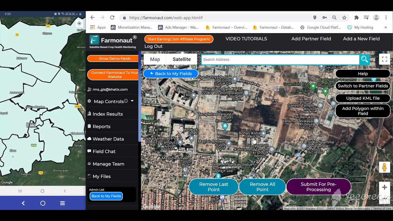
Farmonaut takes the satellite route from the comparison table above: no soil probes to install or maintain, no drone flights to schedule — multispectral satellite imagery delivered through a web, Android, or iOS app.
- ✔ Satellite-Based Crop Health Monitoring: vegetation health, soil moisture, and field condition data via Android, iOS, browser app, and API
- 📊 Farmonaut’s API lets agritech businesses, insurers, and supply chains build monitoring features into their own platforms without deploying field IoT hardware
- ♻ Environmental impact tracking: resource-use data supporting carbon footprinting
- 🔗 Blockchain traceability for supply-chain transparency
- 🚚 Fleet & resource management for monitoring, routing, and auditing farm vehicles

The AI-powered Jeevn advisory layer combines satellite data with weather alerts and operational guidance, aimed at the same automation-without-installed-hardware model: for large or geographically dispersed operations, or land in regions with no cellular coverage for ground sensors, satellite monitoring covers ground that point sensors physically cannot.
- 🌍 Scalable: from single fields to enterprise and government-scale operations
- 🔌 API integration available to extend monitoring into existing farm-management software

Beyond core monitoring, plantation, forest, and crop advisory services extend coverage into every agricultural region, including arid and semi-arid land where ground-sensor networks are costly to maintain.
Irrigation Water Savings Calculator
The figures above show a documented ~30% water-saving range from sensor-based irrigation scheduling. Enter your own acreage, water cost, and current irrigation method to see what that range means for your operation:
Run your own numbers
Assumes the entered savings percentage applies uniformly across the irrigated acreage and that current use reflects a full season’s calendar-based watering. It excludes sensor hardware, installation, and connectivity costs, and excludes yield effects from any change in irrigation timing. The 30% default reflects the documented range in the PMC-published irrigation IoT research cited above; actual results depend on your soil type, crop, and how much your current schedule already deviates from calendar-based watering.
Barriers to Adoption
The USDA adoption data above already answers why uptake concentrates on large farms: fixed costs. A GPS autosteer retrofit or a network of soil-moisture probes costs roughly the same to install whether the field is 40 acres or 4,000 — so the cost per acre falls sharply as farm size rises, and mid-size and small operations rationally adopt the lowest-fixed-cost tools first.
- Upfront hardware cost: the same installation expense spread over fewer acres makes ground-sensor networks and autosteer retrofits proportionally more expensive for smaller operations — one reason satellite-based monitoring, which needs no field hardware, sees interest from smaller farms that ground-sensor vendors don’t reach.
- Connectivity: LoRaWAN and cellular IoT sensors need a functioning gateway signal; land without reliable rural broadband or cell coverage pushes growers toward satellite-based alternatives by default, not by preference.
- Data fragmentation: deploying a soil sensor, a drone, and a yield monitor from three different vendors often means three separate apps and no unified view — the integration work is a real cost that hardware price tags don’t include.
- Skills and time: interpreting sensor and imagery data into an action (spray, irrigate, hold) is a learned skill; extension programs through land-grant universities remain the primary training channel in the US.
None of these barriers are unique to any one region — they show up identically in the adoption gap between large and midsize farms in the ERS chart above (70% vs. 52% for the exact same technology).

Frequently Asked Questions
What is agriculture automation using IoT?
It’s the use of interconnected sensors, software, and machinery to carry out fieldwork — irrigation, fertilization, harvesting, monitoring — with a triggered or scheduled action instead of a manual one. On US large-scale crop farms, the most common form is autosteer-guided machinery, at 70% adoption per USDA ERS 2023 data.
How do IoT sensors improve crop monitoring?
They provide continuous, location-specific data on soil moisture, temperature, and nutrient levels rather than a single manual reading taken periodically. Combined with a yield map (68% of large US crop farms already have one, per USDA), that data supports targeted rather than uniform input decisions.
What’s the difference between crop monitoring IoT and satellite monitoring?
Ground IoT sensors give continuous data from a fixed point but require installed hardware and connectivity. Satellite monitoring covers an entire field or farm with no field hardware, at the cost of lower revisit frequency than a continuously-reporting ground sensor. Most working operations use both for different purposes — see the comparison table above.
Can IoT-based systems work without rural internet access?
Yes — many systems use LoRaWAN (long-range, low-power, doesn’t need cellular data) or satellite uplinks specifically because rural cellular coverage is inconsistent. Satellite-based crop monitoring platforms bypass the connectivity problem entirely since there’s no field-installed sensor that needs a signal.
Is satellite-based monitoring accurate enough to replace ground sensors?
It depends on what you’re measuring. For field-wide vegetation health trends and large-acreage management, satellite imagery is well suited and requires no maintenance. For precise, real-time soil moisture at a specific depth to trigger irrigation valves, a ground sensor remains more direct. The two are complementary rather than substitutes for most operations.
Get Started with Farmonaut
Explore subscription packages for satellite monitoring, AI insights, crop health analysis, and IoT-powered automation support — accessible via web, iOS, Android, and API:
Further reading:
Conclusion
The USDA data settles the core question: IoT-based crop monitoring and automation are not an emerging bet on large US crop farms — they’re already the majority practice, at 70% for autosteer and 68% for yield mapping as of the 2023 ERS survey. The open question is adoption further down the farm-size scale, where fixed hardware costs still don’t pencil out the way they do at scale, and where satellite-based and hybrid-connectivity approaches are the more realistic entry point than a ground-sensor network built for a much larger operation.
Whichever tools fit your acreage and budget, treat every adoption or market figure — including the ones cited in this article — as dated to its survey year. Recheck USDA ERS Charts of Note and NASS QuickStats before making a purchase decision based on an adoption rate that may have moved since 2023.
Try Farmonaut’s satellite-based crop monitoring platform.

 MapMyCrop
 Cresol
 Atur Kuliner
 MDCV UK
 Zerella Group
 Etech Consulting Madagascar
 Vestlandsforsking
 Agritein
 Delicio
 WB Dev
 Sama Premium
 Prochecker
 Tres Valles
 LACOS Geoinformation
 Magrifly
 LatConnect 60
 Blickwinkel
 Agricultural Credit Policy Council
 Marei Nursery
 eKGIS
eKGIS Mostas Tech
